Brian Peters: Showers today, dry Sunday for north, central Alabama
TODAY: Clouds are most prevalent across the Tennessee River Valley this morning, with temperatures starting off in the lower 70s. I expect to see highs once again in the lower 90s, with scattered to numerous showers and thunderstorms.
The Storm Prediction Center has all of Alabama in a marginal risk for severe thunderstorms today. CAPE values are forecast to soar to around 3,400 J/kg this afternoon across the northern half of Alabama, with slightly lower values along the older frontal boundary across south Alabama. I expect to see several severe thunderstorm warnings, with damaging straight-line wind the primary threat.

SUNDAY: Sunday the weather picture changes pretty dramatically. The front to our north this morning will move all the way into south Alabama as the upper trough slides by, providing enough push to get some drier air into the northern half of Alabama. Precipitable water values suggest dry weather for the northern half of Alabama all the way to just north of Montgomery. South Alabama remains in the moisture-rich environment, so showers and storms remain a good bet across south Alabama and northwest Florida. Highs across central Alabama should be in the lower 90s, but dew points will be in the lower to middle 60s, so it should feel a little nicer with the lowered humidity.

NEXT WEEK: There is not much change on Monday. The frontal boundary is forecast to stall across south Alabama, with the drier air in place across the northern half of Alabama. So once again north and central Alabama should remain shower-free, but showers will still be possible from about Clanton southward to the beach.
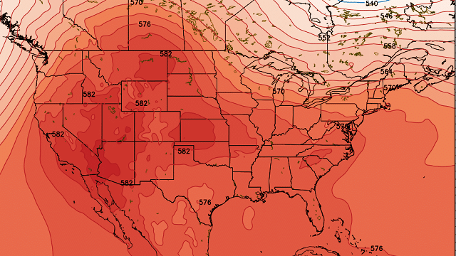
From Tuesday through Thursday the upper trough weakens even more as the strong upper ridge centered over the Southwest U.S. noses into the Lower Mississippi River Valley and the Southeast. By Thursday we’re looking at some of the highest thickness values we’ve seen all summer. I believe we will be seeing highs push the upper 90s very strongly. This will be a brief taste of the excessive heat that upper ridge can generate. Moisture levels have gone back up, so scattered showers driven by the heating of the afternoon will be back in the forecast.

Here’s hoping the Global Forecast System is correct next Friday and Saturday as it brings a strong trough across Canada that digs into the East Coast, once again pushing the strong upper ridge back into the Rockies and western U.S. This would bring our temperatures somewhat cooler, with highs mainly in the lower half of the 90s. Scattered showers remain possible each day with afternoon heating.
BEACH FORECAST: The weather at the beach will include the possibility of passing showers just about every day for the next seven days, with highs in the upper 80s. There is no indication of any all-day rain situation, so you should be able to enjoy the beach with only short interruptions for a passing shower. Please heed those showers and don’t become a lightning statistic. The rip current threat is low for the next couple of days. Click here to see the AlabamaWx Beach Forecast Center page.
TROPICS: The tropical Atlantic is once again quiet as Tropical Depression Four has become an open wave with just a few showers and some clouds. The eastern North Pacific still has only one area of concern, but that area is now Eugene. And Eugene is forecast to reach hurricane strength, but he will remain in the open water as the course parallels the Mexican coast.
Have a great day, and Godspeed.
For more weather news and information, visit AlabamaWx.


