James Spann: Nate to bring wind, rain to Alabama this weekend

CALM BEFORE THE STORM: Temperatures are in the 80s across Alabama this afternoon under a sunny sky, but tropical trouble is lurking to the south for the weekend.
Tropical Storm Nate will clip the tip of the Yucatan Peninsula tonight and enter the Gulf of Mexico early tomorrow morning. It moves near the mouth of the Mississippi River (extreme southeast Louisiana) tomorrow night, and then into the Mississippi coast during the pre-dawn hours Sunday as a Category 1 hurricane, based on the latest National Hurricane Center outlook.

A Hurricane Warning is in effect for all of the Alabama Gulf Coast. Here are the important points concerning Nate this afternoon:
- A Hurricane Warning is in effect from Grand Isle, Louisiana, to the Alabama/Florida border.
- A Storm Surge Warning is in effect from Morgan City, Louisiana, to the Alabama/Florida border, and for the northern and western shores of Lake Pontchartrain.
- A Tropical Storm Warning is in effect for metropolitan New Orleans, Lake Pontchartrain, Lake Maurepas and from west of Grand Isle to Morgan City, Louisiana.
- A Hurricane Watch is in effect for metropolitan New Orleans, Lake Pontchartrain and Lake Maurepas; from east of the Alabama/Florida border to the Okaloosa/Walton County line; and from west of Grand Isle to Morgan City, Louisiana.
- A Storm Surge Watch is in effect from east of the Alabama/Florida border to Indian Pass, Florida.
- A Tropical Storm Watch is in effect from east of the Okaloosa/Walton County line to Indian Pass, Florida, and from west of Morgan City to Intracoastal City, Louisiana.
- The combination of a dangerous storm surge and the tide will cause normally dry areas near the coast to be flooded by rising waters moving inland from the shoreline. The water is expected to reach the following heights above ground if the peak surge occurs at the time of high tide: 4 to 7 feet from Morgan City, Louisiana, to the Alabama/Florida border; and 2 to 4 feet from the Alabama/Florida border to Indian Pass, Florida.
- The deepest water will occur along the immediate coast near and to the east of the landfall location, where the surge will be accompanied by large and destructive waves. Surge-related flooding depends on the relative timing of the surge and the tidal cycle, and can vary greatly over short distances.
- For north and central Alabama, most of the rain will come late Saturday night into Sunday. Rain amounts should average 2 to 5 inches, with isolated totals to 6 inches. Some flooding is possible.
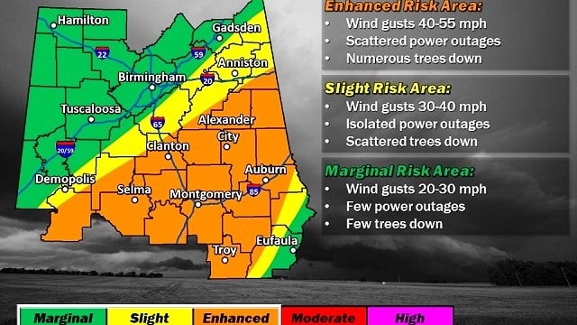
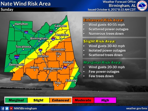
- Gradient winds over north Alabama (including Birmingham, Tuscaloosa, Anniston and Gadsden) will be in the 20-40 mph range Sunday. Higher winds of 40-55 mph are now expected across parts of central Alabama, generally south of a line from Demopolis to Clanton to Wedowee. Some tree and power line damage is possible in this zone Sunday.
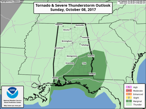
- The highest risk of tornadoes with Nate will come over the southern half of Alabama over the weekend. The tornado threat for the northern half of the state is low.
- Wind and rain will diminish across north and central Alabama late Sunday night. Showers remain possible Monday, however.
FOOTBALL WEATHER: For the high school games tonight, the sky should be clear with temperatures falling from around 80 degrees at kickoff through the 70s during the game.
Auburn hosts Ole Miss Saturday at Jordan-Hare Stadium (11 a.m. kickoff). The sky will be partly sunny, with temperatures rising from near 78 degrees at kickoff into the low 80s by the final whistle. A few scattered showers are possible, but the most widespread rain comes well after the end of the game.
Alabama is on the road, taking on the Texas A&M Aggies in College Station, Texas, on Saturday (6:15 p.m. kickoff). The sky will be clear, with temperatures falling from near 88 degrees at kickoff to near 80 by the end of the game.
UAB’s homecoming is Saturday; the Blazers take on Louisiana Tech at Legion Field (3 p.m. kickoff). For now we are forecasting a partly sunny sky with 83 degrees at kickoff, falling to near 80 by the fourth quarter. A passing shower is possible, but not likely.
NEXT WEEK: Showers remain possible Monday and Tuesday as Nate will leave behind a humid tropical air mass. The weather slowly trends cooler and drier over the latter half of the week.
BEACH FORECAST: Click here to see the AlabamaWx Beach Forecast Center page.
WEATHER BRAINS: You can listen to our weekly 90-minute netcast anytime on the web, or on iTunes. This is the show all about weather featuring many familiar voices, including meteorologists at ABC 33/40.
CONNECT: You can find me on all of the major social networks:
Facebook
Twitter
Google Plus
Instagram
Pinterest
Snapchat: spannwx
For more weather news and information from James Spann and his weather team, visit Alabama Wx.


