James Spann: Rain mostly holds off until the weekend in Alabama
James Spann: Nice weather week for Alabama from Alabama NewsCenter on Vimeo.
CHILLY MORNING: Our Skywatcher at Black Creek, just northeast of Gadsden, reports 31 degrees early this morning with frost. Most spots are in the upper 30s and low 40s, and the sky is clear. Today will be much like yesterday; with a good supply of sunshine we rise into the mid 60s this afternoon.
Not much change tomorrow through Friday. We will mention a small risk of a shower tomorrow evening near the Tennessee border with an approaching front, but otherwise dry weather continues with pleasant afternoons and cool nights. Highs will be in the mid 60s tomorrow, upper 60s Thursday and near 70 Friday. Lows generally will be in the 40s.
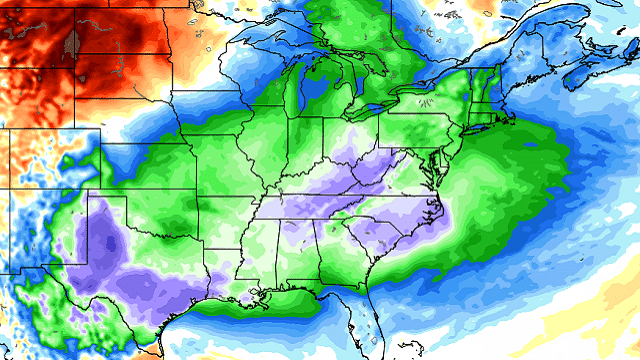
THE ALABAMA WEEKEND: There’s lots of uncertainty because of some big model disagreement. The Global Forecast System suggests a cold front will bring a band of showers, and maybe a thunderstorm, into the state during the day Saturday, but the ECMWF (European) model holds the showers off until after midnight Saturday night into early Sunday morning. In our forecast we will trend toward the slower Euro solution, and mention just the chance of a shower Saturday afternoon, with showers becoming more likely Saturday night, then ending early Sunday. The high Saturday will be in the 65- to 70-degree range.
On a positive note, the Storm Prediction Center has dropped the severe weather threat that was defined earlier for areas north and west of Alabama Friday, and for now we do not expect any severe weather issues here this weekend.
Sunday should be noticeably colder, but again we have model disagreement in the depth of the cold air. The GFS suggests the high Sunday will be near 50 with a brisk north wind, but the European shows a high closer to 60. We will pretty much split the difference in the forecast. Most of Sunday should be dry after showers end early in the day.
FOOTBALL WEATHER: For high school playoff games Friday night, the weather looks pleasant and dry with temperatures falling from the mid 60s at kickoff to near 60 by the final whistle.
Saturday, Alabama hosts the Mercer Bears at Bryant-Denny Stadium (11 a.m. kickoff). For now it looks like the best chance of rain will hold off until after the game is over; just an outside risk of a shower, with temperatures in the 60s.
Auburn will host Louisiana-Monroe Saturday at Jordan-Hare Stadium (11 a.m. kickoff). Just a small risk of a shower; like the situation in Tuscaloosa, it looks like the best chance of rain comes after the end of the game. Temperatures will be in the 60s.
UAB will be down in Gainesville to take on the Florida Gators (kickoff at 3 p.m. Central). The sky will be mostly sunny with a kickoff temperature near 78 degrees. Clouds will increase late in the game, but for now the weather looks dry with temperatures falling to near 70 by the final whistle.
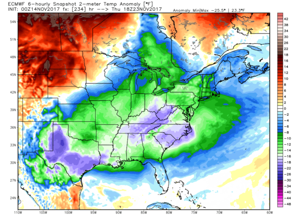
NEXT WEEK: There is potential for a fairly widespread freeze early Monday morning with temperatures in the upper 20s and low 30s. Dry weather is likely during the first half of the week; highs iwill be n the 50s Monday, and back in the 60s Tuesday and Wednesday. Global models continue to show a cold pattern developing for Thanksgiving, Black Friday and Iron Bowl Saturday, but it’s way too early to be specific.
TROPICS: A system in the eastern Atlantic south of the Azores could become a tropical or subtropical storm over the next five days, but will be no threat to North America. The rest of the Atlantic basin is very quiet.
BEACH FORECAST: Click here to see the AlabamaWx Beach Forecast Center page.
WEATHER BRAINS: You can listen to our weekly 90-minute netcast anytime on the web, or on iTunes. This is the show all about weather featuring many familiar voices, including meteorologists at ABC 33/40.
CONNECT: You can find me on all of the major social networks:
Facebook
Twitter
Google Plus
Instagram
Pinterest
Snapchat: spannwx
For more weather news and information from James Spann and his team, visit AlabamaWx.


