James Spann: Severe storms likely in Alabama later today, tonight
James Spann: Severe weather, including tornadoes, possible throughout Alabama today from Alabama NewsCenter on Vimeo.
CALM START: We have a few patches of light rain on radar this morning over the northern half of the state, but nothing heavy or widespread. The sky is mostly cloudy with temperatures in the upper 50s and low 60s. But, later today, parameters will come together for strong to severe thunderstorms.
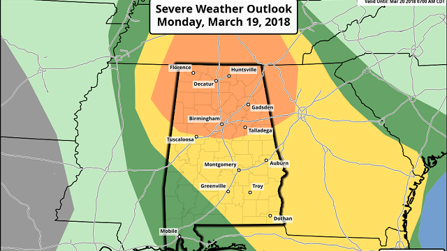
ENHANCED RISK: The Storm Prediction Center maintains an “enhanced risk” of severe weather for much of north Alabama, generally north of I-20 — north of a line from Tuscaloosa to Columbiana to Sylacauga to Ranburne. A “slight risk” is down to York, Monroeville and Andalusia, and a “marginal risk” covers southwest Alabama, places like Mobile and Gulf Shores.

Concerning the probabilistic outlook, there is a 10 percent chance of a tornado within 25 miles of a given point within the enhanced risk area.

The air becomes unstable across our state this afternoon, and, with strong wind fields scattered, severe storms are likely. Not everyone will see a severe storm today, but where they form they will mean business.
TIMING: I am going to expand the window for severe storms to cover a broad 12-hour period, from noon through midnight. However, the core threat remains from 3 p.m. until 10 p.m. High-resolution modeling suggests a few showers or storms could form early this afternoon over parts of west and northwest Alabama; it remains to be seen if these tap into the instability, but it is possible. The main action comes after 3 as the best dynamic support approaches. The threat should be over in the Birmingham metro area by 10, but a few storms could linger over east Alabama through midnight.
THREATS: Any storm that forms later today and tonight will be capable of producing large hail, possibly to baseball size, damaging straight-line winds and a tornado. A strong tornado or two can’t be ruled out. The highest tornado threat will be in the “enhanced risk” area over north Alabama, but those in the “slight risk” should understand a tornado is possible there as well.
RAIN: Because of the scattered nature of the storms, rain amounts will be highly variable. Heavier storms will bring around one-half inch; some places won’t see much rain at all. No flooding issues to worry about.
CONFIDENCE: Overall forecast confidence is high; we have no storms on the Gulf Coast to disrupt the inflow, and rain overnight had little impact on the atmospheric conditions.
NO NEED TO BE AFRAID: This is the core of the spring tornado season; events like this are common and are not unprecedented. Just be able to hear warnings, have a plan and we will get through the day just fine.
CALL TO ACTION: Here are some important action points for today:
- Be sure you can hear warnings if needed. NEVER rely on an outdoor warning siren; if that is your main way of hearing warnings, you have little hope of hearing them indoors. Have a NOAA Weather Radio in your home or business, and a good app designed for warnings on your smartphone like WeatherRadio by WDT.
- Know the safe place in your home — small room, lowest floor, away from windows and near the center of the house. If you live in a mobile home, you have to leave and go to a shelter or site-built structure.
- In your safe place, be sure you have a helmet for everyone to wear (not just children). It is also good for everyone to have a portable air horn (to get the attention of first responders if you need help), and be sure and wear hard-sole shoes (you don’t want to walk over a tornado debris field with tennis shoes or bare feet).
REST OF THE WEEK: Tomorrow will be cloudy and colder with a high in the 50s; some scattered light rain is possible. Then, we head down toward the low 30s early Wednesday morning; some places could see a light freeze. The coldest morning this week will come early Thursday with a clear sky and calm wind; lows should be in the upper 20s and low 30s with widespread frost. No rain Wednesday and Thursday; just a small risk of a shower Friday afternoon.
We will mention a chance of showers and possibly a thunderstorm over the weekend, mainly late Saturday and Saturday night, as a cold front passes through.

BEACH FORECAST: Click here to see the AlabamaWx Beach Forecast Center page.
WEATHER BRAINS: You can listen to our weekly 90-minute netcast any time on the web or on iTunes. This is the show all about weather featuring many familiar voices, including meteorologists at ABC 33/40.
CONNECT: You can find me on all of the major social networks:
Facebook
Twitter
Google Plus
Instagram
Pinterest
Snapchat: spannwx
For more weather news and information from James Spann and his team, visit AlabamaWx.


