Gov. Kay Ivey issues state of emergency in anticipation of Alberto

The projected path of Alberto as of 4 p.m. Saturday. (NOAA)
Alabama Gov. Kay Ivey has issued a State of Emergency effective at 6 a.m. Sunday for several Alabama counties in preparation for Subtropical Storm Alberto.
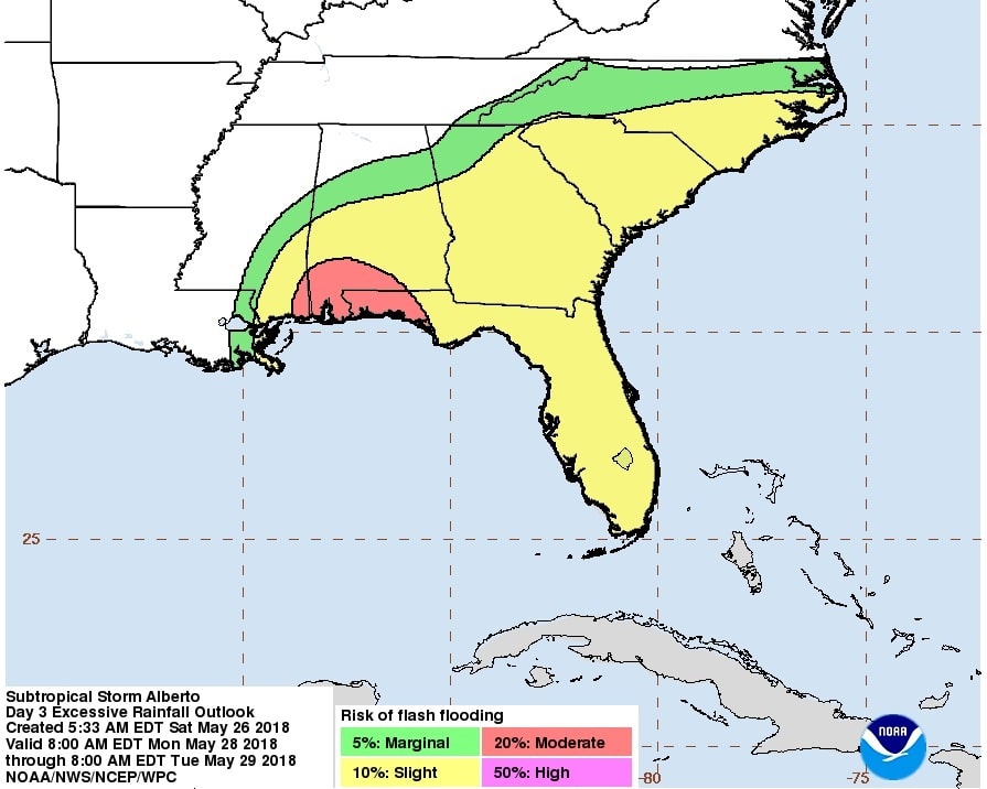
Alberto flash flooding risks. (NOAA)
Counties included Autauga, Baldwin, Barbour, Bibb, Bullock, Butler, Chambers, Chilton, Choctaw, Clarke, Coffee, Conecuh, Coosa, Covington, Crenshaw, Dale, Dallas, Elmore, Escambia, Geneva, Greene, Hale, Henry, Houston, Lee, Lowndes, Macon, Marengo, Mobile, Monroe, Montgomery, Perry, Pickens, Pike, Russell,
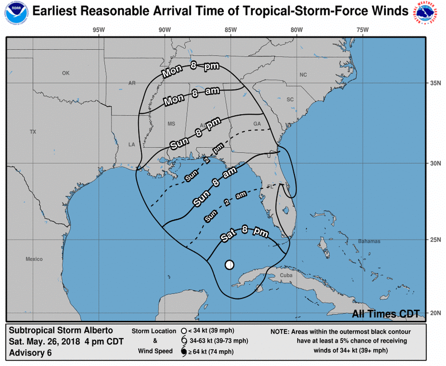
Expected arrival of storm-force winds. (NOAA)
Sumter, Tallapoosa, Tuscaloosa, Washington and Wilcox.
Heavy rains are the biggest concern as they may lead to extremely serious flash and river flooding. There is also a prolonged tornado threat for much of the state beginning near the coast on Sunday and lasting into at least Tuesday night in north Alabama.
“All Alabamians should take time to be prepared for the potential of significant flooding,” Ivey said in a statement. “I have directed essential state agencies to be on the ready should they be needed over the next couple of days. As with any tropical weather event, being prepared is of utmost importance. Everyone should take the necessary precautions now and stay informed of the latest weather conditions for their area. This State of Emergency will ensure that all available state resources are ready when they are needed.”
Ivey has directed the State Emergency Operations Center in Clanton has been activated since Friday in preparation for Alberto and The Alabama National Guard has activated its High-Water Evacuation Teams to support Divisions A and B, in the coastal and southeastern portion of the state. Both Divisions, A and B, will activate Sunday morning. The National Guard soldiers will also provide support in the command and control center.
“There is still uncertainty of where landfall will occur, which will likely be late Monday or early Tuesday morning,” Director of Alabama Emergency Management Agency Brian E. Hastings said. “Regardless of the final track and intensity of Alberto, we know it will produce heavy rainfall and flash flooding in several counties, and the time to prepare is now. Residents and tourist are strongly encouraging people to closely monitor this forecast.”
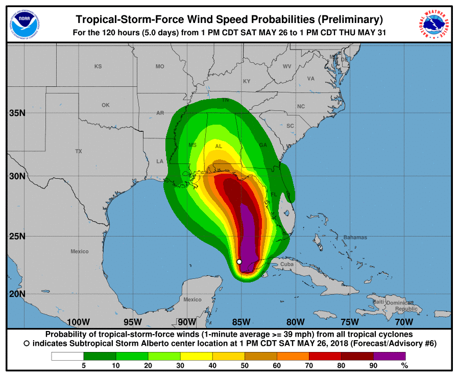
Alberto wind speed probabilities. (NOAA)
By declaring a State of Emergency, Governor Ivey is directing the appropriate state agencies to exercise their statutory authority to assist the communities and entities impacted by Subtropical Storm Alberto.
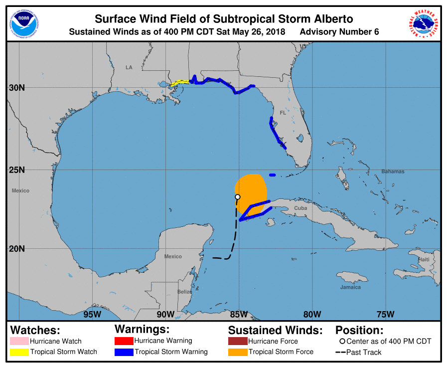
The latest advisory from AlabamaWx.com has a Tropical Storm Warning issued for the west coast of the Florida peninsula from Bonita Beach to the Anclote River and for the northern Gulf Coast from the Aucilla River westward to the Mississippi/Alabama border.
A Storm Surge Watch is in effect for Crystal River in Florida to the Mouth of the Pearl River in Mississippi.
A Tropical Storm Watch is in effect for the Mississippi/Alabama border to the Mouth of the Pearl River.
A Tropical Storm Warning means that tropical storm conditions are expected somewhere within the warning area. A Tropical Storm Watch means that tropical storm conditions are possible in the United States portion of that watch area within 48 hours.
Alberto watches and warnings. (NOAA)
At 4 p.m. Saturday the center of Subtropical Storm Alberto northwest of Cuba moving toward the north near 13 mph. A slower northward or north-northeastward motion is expected tonight, followed by a north-northwest turn on Sunday, and this general motion should continue into Tuesday. On the forecast track, the center of Alberto is expected to move over the eastern Gulf of Mexico tonight through Sunday night, and approach the northern Gulf Coast in the warning area on Monday. Heavy rainfall and tropical storm conditions will likely reach the northern Gulf Coast well before the arrival of the center of Alberto.
Maximum sustained winds are near 40 mph with higher gusts. Gradual strengthening is forecast until the system reaches the northern Gulf Coast on Monday. Winds of 40 mph extend outward up to 140 miles primarily to the east of the center.
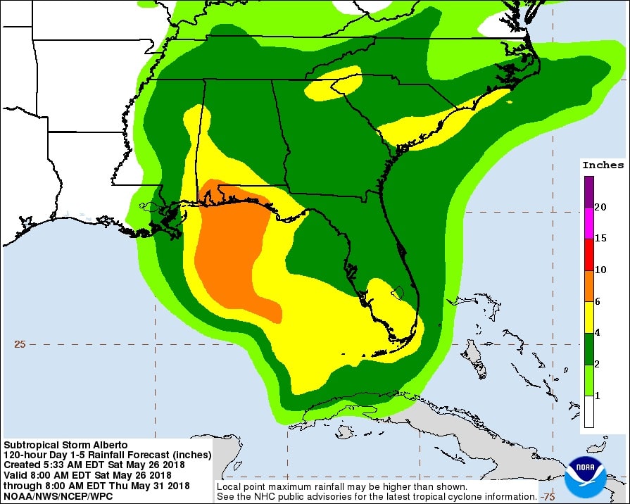
Alberto rainfall predictions. (NOAA)
Heavy rains will begin to affect the central Gulf Coast region into the southeastern United States on Sunday and continue into the middle of next week as Alberto moves northward after landfall. Rainfall totals of 5 to 10 inches with maximum amounts of 15 inches are possible along the track of Alberto from eastern Louisiana, across much of Mississippi, Alabama, western Tennessee and the western Florida panhandle. Rainfall totals of 3 to 5 inches with maximum totals of 8 inches are possible from the southern Appalachians into the coastal southeast United States.
The combination of storm surge and the tide will cause normally dry areas near the coast to be flooded by rising waters moving inland from the shoreline. The water could reach the following heights above ground somewhere in the indicated areas if the peak surge occurs at the time of high tide.
Swells generated by Alberto are expected to spread northward along the eastern and northern Gulf Coast through Monday. These swells are likely to cause life-threatening surf and rip current conditions.


