James Spann: Mild weather for Alabama through Tuesday; Wednesday much colder
James Spann has the forecast for Monday and the work week ahead from Alabama NewsCenter on Vimeo.
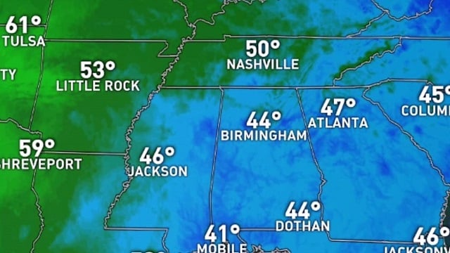
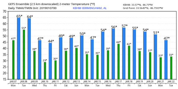
ANOTHER PLEASANT MIDWINTER DAY: After a chilly start, with lows in the 30s and 40s, we expect a high in the mid to upper 60s across north and central Alabama this afternoon, with readings near 70 for the southern counties of the state. The air stays dry, and the sky will be partly to mostly sunny.
An approaching cold front will bring some clouds in here tonight and tomorrow, and the system could squeeze out a few widely scattered showers — nothing heavy or widespread; rain amounts will be light and spotty. We stay mild tomorrow with a high in the 60s.
TURNING COLDER: Colder air flows into the state tomorrow night, and Wednesday will feature a high only in the 48- to 52-degree range despite sunshine in full supply. A northwest wind of 10-20 mph will make it feel colder. Wednesday night will be cold; we drop into the 20s early Thursday morning with a clear sky and light wind.
The weather will stay dry but rather chilly Thursday and Friday, with a high between 45 and 52 degrees both days and a good supply of sunshine. Another freeze is likely early Friday morning, with lows in the 20s. Clouds will return Friday night.
THE ALABAMA WEEKEND: Saturday will be a cloudy, cool day, and some light rain is possible as a surface wave moves eastward along the Gulf Coast. The high will be close to 50 degrees; some north Alabama communities won’t get out of the 40s. For now it looks like most of Sunday will be dry as the wave moves east of the state, but model consistency has not been good, and forecast confidence is not especially high at this point. The high Sunday should be in the 50s. Just be aware that forecast changes could be required for the weekend in coming days.
NEXT WEEK: For now, most of the week looks dry with seasonal temperatures — highs in the 50s and lows in the 30s. It seems like the next chance of rain comes toward the end of the week, around Friday, Jan. 17.
FOOTBALL WEATHER: For tonight’s national championship game in Santa Clara, California (Alabama vs. Clemson, Levi’s Stadium, 7 p.m. Central Time), the sky will be cloudy, but we are not expecting anything more than widely scattered showers. Temperatures will be in the 50s.
ON THIS DATE IN 1988: A major snow storm hit the South; the heaviest snow in Alabama was over the Tennessee Valley, where Huntsville measured 9.6 inches. Storm total accumulations ranged from around 2 inches in the Smith Lake area of southern Cullman County to more than 10 inches in the far northeast corner of Alabama, with the majority of the area seeing more than half a foot. At least a trace of snow remained on the ground in Huntsville for nine days after the snow began, with at least a half foot of snow remaining on the ground for four days. Around a million chickens were killed when the houses they were in collapsed from snow and ice accumulations. An additional quarter million birds survived but were not economically salvageable. Damage to poultry houses were estimated to be more than $15 million in Cullman, Morgan, Marshall, DeKalb and Lawrence counties. This prompted Gov. Guy Hunt to declare a state of emergency for north Alabama.
BEACH FORECAST: Click here to see the AlabamaWx Beach Forecast Center page.
WEATHER BRAINS: You can listen to our weekly 90-minute show any time on your favorite podcast app. This is the show all about weather featuring many familiar voices, including meteorologists at ABC 33/40.
CONNECT: You can find me on all of the major social networks:
Facebook
Twitter
Instagram
Pinterest
Snapchat: spannwx
For more weather news and information from James Spann and his team, visit AlabamaWx.


