Scott Martin: Potential for strong to severe storms in Alabama today
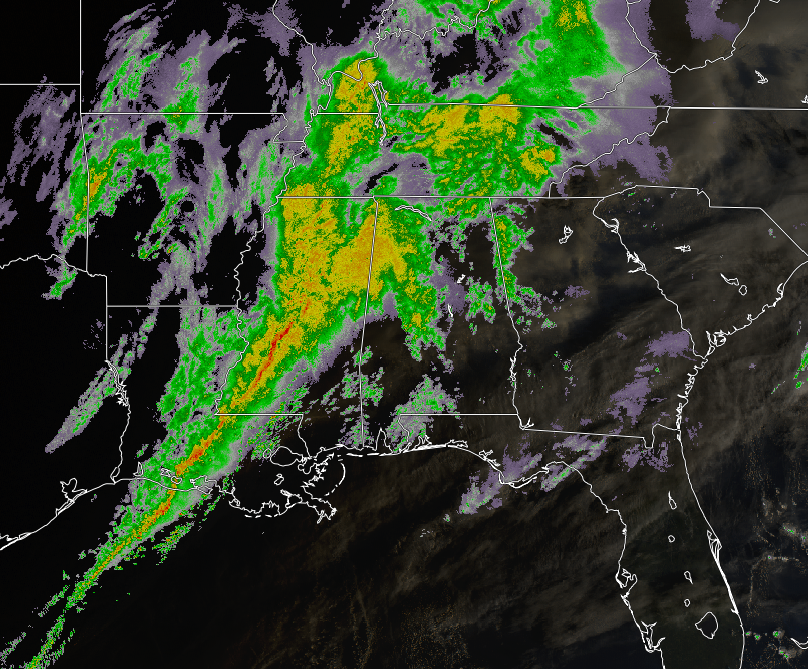
TODAY: Radar shows scattered showers over the eastern half of north and central Alabama this morning, with more moderate rain over the western half. The heavier showers are starting to move into the western portions of Jefferson and Shelby counties, while the rain is starting to taper off for a little while in Tuscaloosa.
We have a wind advisory in effect for all of north and central Alabama through 7 p.m.
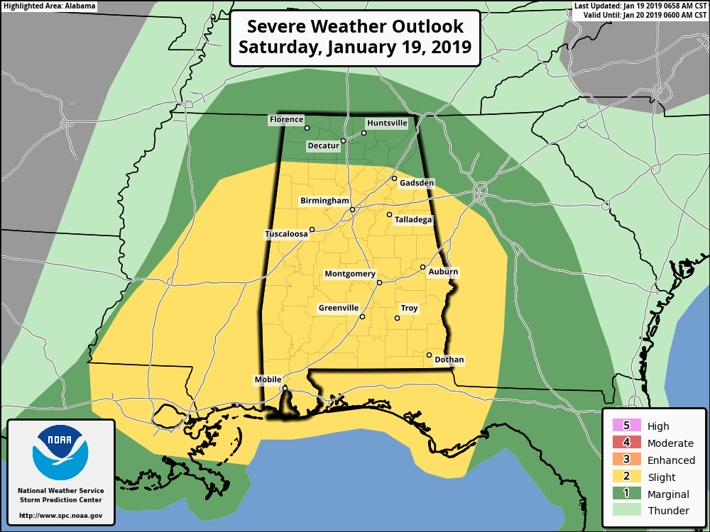
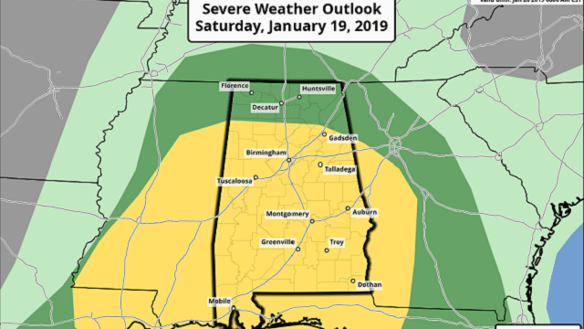
The Storm Prediction Center has nearly all of central Alabama in a slight risk for severe storms throughout the day, with all of north Alabama in a marginal risk. The main threats today will be from damaging thunderstorm wind gusts up to 60 mph, but one or two brief spin-up tornadoes are also possible.
We have the potential for strong to severe thunderstorms throughout the day and into the early evening, but the threat is conditional. We’ll have the shear and dynamics in place, but the limiting factor will be the amount of instability that can work in here. It doesn’t take much to get storms started, but if it comes in less than forecast, it will be a line of rain with gusty winds. If it comes in as modeled or higher, then you can expect some stronger to severe storms to form. Just be sure to have your severe weather safety plan ready to go just in case your locations go under a warning.
Timing on the threat of strong to severe storms will be from 10 a.m. through 7 p.m. The High Resolution Rapid Refresh shows that at 9 a.m. the main squall line should be knocking on the door of the western locations. By 2 p.m., the line will have moved through the western parts of Alabama and should be in the central parts, affecting the Birmingham metropolitan area. By 7 p.m., the line of storms will have moved out of Alabama and into Georgia, ending the threat of severe weather.
Behind the front, we could have a few lingering showers and a few flurries possible through the remainder of the late night and into the first few hours on Sunday. No accumulations are expected, so we should not have any travel issues. Winds will remain in the 10-20 mph range out of the northwest throughout the evening.
Today’s highs will top out in the lower 60s to the lower 70s, with tonight’s lows dipping into the upper 20s to the mid-30s. Rainfall amounts throughout the day will be around 1-2 inches. While widespread flooding problems are not expected, we could have a few localized ponding or flooding issues in poor drainage areas.
SUNDAY: We’ll have clearing skies with a brisk northwesterly wind around 10-20 mph with gusts up to 25 mph at times. Afternoon highs will top out in the upper 30s to the mid-50s. Clear skies can be expected overnight, with lows in the 20s. A few of the colder spots could briefly dip into the upper teens right before sunrise.
NEXT WEEK: Monday will be a nice but cool day featuring plenty of sunshine and light winds. Afternoon highs will be in the lower 40s to the lower 50s.
On Tuesday, we’ll have another frontal system that will be getting its act together just off to our west, with a low centered over northwestern Missouri. The day will start off mostly clear, but clouds will start to move in by noon and we’ll have a chance of showers by the evening before rain becomes likely overnight. Daytime highs will be in the lower 50s to the lower 60s.
We’ll continue to have showers likely throughout the day on Wednesday as a low will be stationed over New Orleans. As the low moves northeastward and starts to lift the system out of the area, we could see a brief changeover to some snow flurries or sleet on the backside. Once again, no accumulations or travel issues are expected. Afternoon highs will be in the lower 50s to the upper 60s.
We’ll still have a few showers lingering around during the morning on Thursday, but we should be dry by midday and skies will begin to clear during the afternoon and evening. Highs will be in the mid-40s to the mid-50s from northwest to southeast.
Friday looks to be dry with partly to mostly sunny skies and cooler temperatures. Daytime highs will be in the mid-40s to the lower 50s.
For more weather news and information from James Spann, Scott Martin and other members of the James Spann team, visit Alabama Wx.


