James Spann: Showers for Alabama today; dry Tuesday, Wednesday
James Spann has the Alabama forecast to start the work week from Alabama NewsCenter on Vimeo.
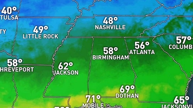
SHOWERS POSSIBLE TODAY: Today will be mostly cloudy across Alabama with the potential for a few passing rain showers thanks to a nearly stationary front across the state, and a weak upper disturbance passing through. Rain amounts, most likely, won’t be too heavy, and there is no risk of severe weather. There will be a big temperature variation because of the front; north Alabama will see highs in the 50s, central Alabama in the 60s and the southern third of the state in the 70s.
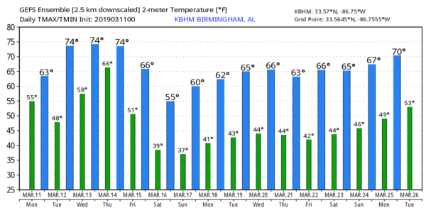
Showers will end tonight as the front lifts north of the state. Tuesday and Wednesday will be dry and mild with a mix of sun and clouds. Afternoon highs will be in the 70s. Some Alabama communities could reach the 80-degree mark Wednesday afternoon.
THURSDAY/FRIDAY: A very deep surface low will move from the Great Plains to the Great Lakes during midweek and will drag a cold front into Alabama Thursday along with a band of showers and thunderstorms. While a few strong storms are possible, at this point the chance of organized severe weather looks low with the main upper support far to the north. Rain amounts Thursday and Thursday night should be around 1 inch, and the rain should end early in the day Friday as the front sags southward. The sky becomes partly sunny Friday afternoon as dry air works into the state. The high Thursday will be well up in the 70s, but then we fall back into the low 60s Friday.
THE ALABAMA WEEKEND: For a change, we won’t have a threat of severe thunderstorms this weekend — in fact, no rain, as cool, dry air will cover the state. Look for a good supply of sunshine both days with highs between 59 and 62. Early-morning lows will drop into the 30s, and some frost is possible Saturday and Sunday mornings. No doubt we will have potential for a freeze across colder pockets of north and central Alabama; growers will need to keep an eye on temperature forecasts.
NEXT WEEK: A disturbance could bring a few showers to parts of Alabama Monday; for now it looks like the best chance of rain will come across the eastern and southern counties. Then, midweek looks dry with seasonal temperatures. For now we see no sign of any major severe weather problems for the next seven to 10 days.
ON THIS DATE IN 1888: The Great Blizzard of 1888 paralyzed the east coast from the Chesapeake Bay to Maine on March 11-14. The blizzard dumped as much as 55 inches of snow in some areas, and snow drifts of 30 to 40 feet were reported. An estimated 400 people died from this blizzard.
WEATHER RADIO PROGRAMMING IN JACKSONVILLE: We will be in Jacksonville next Monday night, March 18, programming weather radios. Bring your weather radio and we will check it for you; we will be on the fifth floor of Jacksonville State University Stadium from 4 until 6:30 p.m. I will be there doing weather live on ABC 33/40.

BEACH FORECAST: Click here to see the AlabamaWx Beach Forecast Center page.
WEATHER BRAINS: You can listen to our weekly 90-minute show any time on your favorite podcast app. This is the show all about weather featuring many familiar voices, including the meteorologists at ABC 33/40.
CONNECT: You can find me on the major social networks:
Facebook
Twitter
Instagram
Pinterest
Snapchat: spannwx
For more weather news and information from James Spann and his team, visit AlabamaWx.


