James Spann: Drier air arrives in Alabama Wednesday
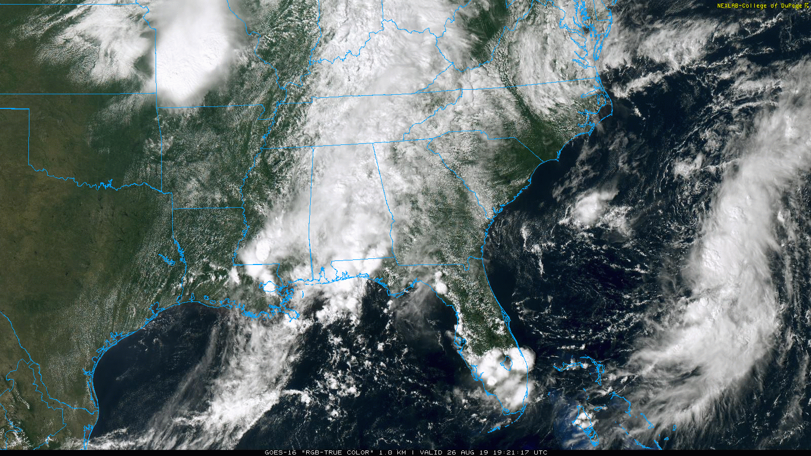
WET SUMMER DAY: This has been a very wet late August day across Alabama, and rain remains widespread across the state this afternoon. Temperatures are only in the 70s because of clouds and rain, and Fort Payne reports a cool 68 degrees at mid-afternoon. Periods of rain will continue tonight as an upper trough interacts with deep tropical moisture in place across the state.
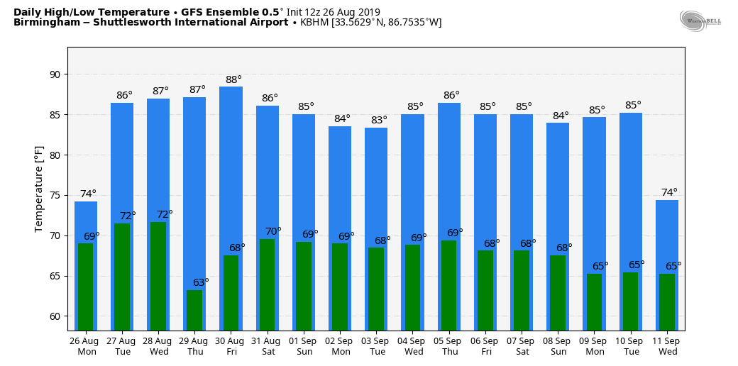
I do think we will see some sun at times Tuesday, but again we will forecast scattered to numerous showers and thunderstorms in the moist air mass. The high will be back in the mid 80s for most communities.
WEDNESDAY THROUGH FRIDAY: Drier air arrives over North Alabama Wednesday. The day will be dry there, with showers confined to the southern half of the state. Then, all of Alabama will enjoy a dry, pleasant day Thursday with lots of sunshine, lower humidity and a cool morning for August. Some of the cooler spots across north and central Alabama could see a low in the 50s early Thursday morning.
Friday will be dry for most of the state, but showers are possible over some of the southern counties as moist air begins to return. Highs will be mostly in the mid to upper 80s Wednesday through Friday.
LABOR DAY WEEKEND: Showers are possible statewide Saturday, but they should be more numerous over the southern counties of Alabama. Then, expect scattered to numerous showers and thunderstorms Sunday and Monday as moisture levels rise. This won’t be an all-day kind of rain, but occasional showers are likely. Highs over the weekend will be in the upper 80s Saturday and in the mid 80s Sunday and Monday.
NEXT WEEK: Quite frankly, the weather Tuesday through midweek will all depend on the situation with what is now Tropical Storm Dorian. For now we will broad-brush the forecast with the usual early September pattern (warm, humid, scattered showers and storms), but be aware the forecast can and probably will change as we get better clarity on the tropical situation.
FOOTBALL WEATHER: UAB will host Alabama State Thursday night at Birmingham’s Legion Field; the kickoff is at 7. The weather will be delightful — a clear sky with temperatures falling from near 85 at kickoff into the 70s during the second half.
Alabama will take on Duke in the Chick-fil-A Kickoff Classic in Atlanta (2:30 p.m. Central kickoff). The game will be played indoors at Mercedes-Benz Stadium, but outside the sky will be partly sunny with potential for a few scattered showers. Temperatures will peak in the mid to upper 80s in Atlanta Saturday afternoon.
Auburn travels to Dallas/Fort Worth to take on Oregon at AT&T Stadium Saturday evening (7:30 Central kickoff). Temperatures will top out in the 90s during the day Saturday, falling though the 80s during the game. Only widely scattered showers are expected, and there is a retractable roof at the venue.
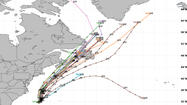
TROPICS: A well-organized system (Invest 98L) is well east of Charleston, and is expected to become a tropical depression or storm tonight. It will move northeast toward the Canadian maritimes and is no threat to the U.S.
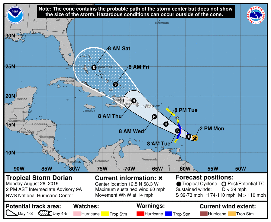
Tropical Storm Dorian is packing sustained winds of 60 mph. On the forecast track, the center of Dorian is expected to be near the Windward Islands late today and tonight, and move into the eastern Caribbean Sea Tuesday. Dorian is expected to pass near or south of Puerto Rico on Wednesday and approach eastern Hispaniola Wednesday night as a category one hurricane.
Interaction with Hispaniola and possibly Puerto Rico should result in some weakening in 72-96 hours, followed by restrengthening on day 5, when Dorian will be moving over the very warm waters in the Bahamas in low shear conditions. Given the unknown degree of interaction with Hispaniola, the intensity forecast at days 4 and 5 is of very low confidence.
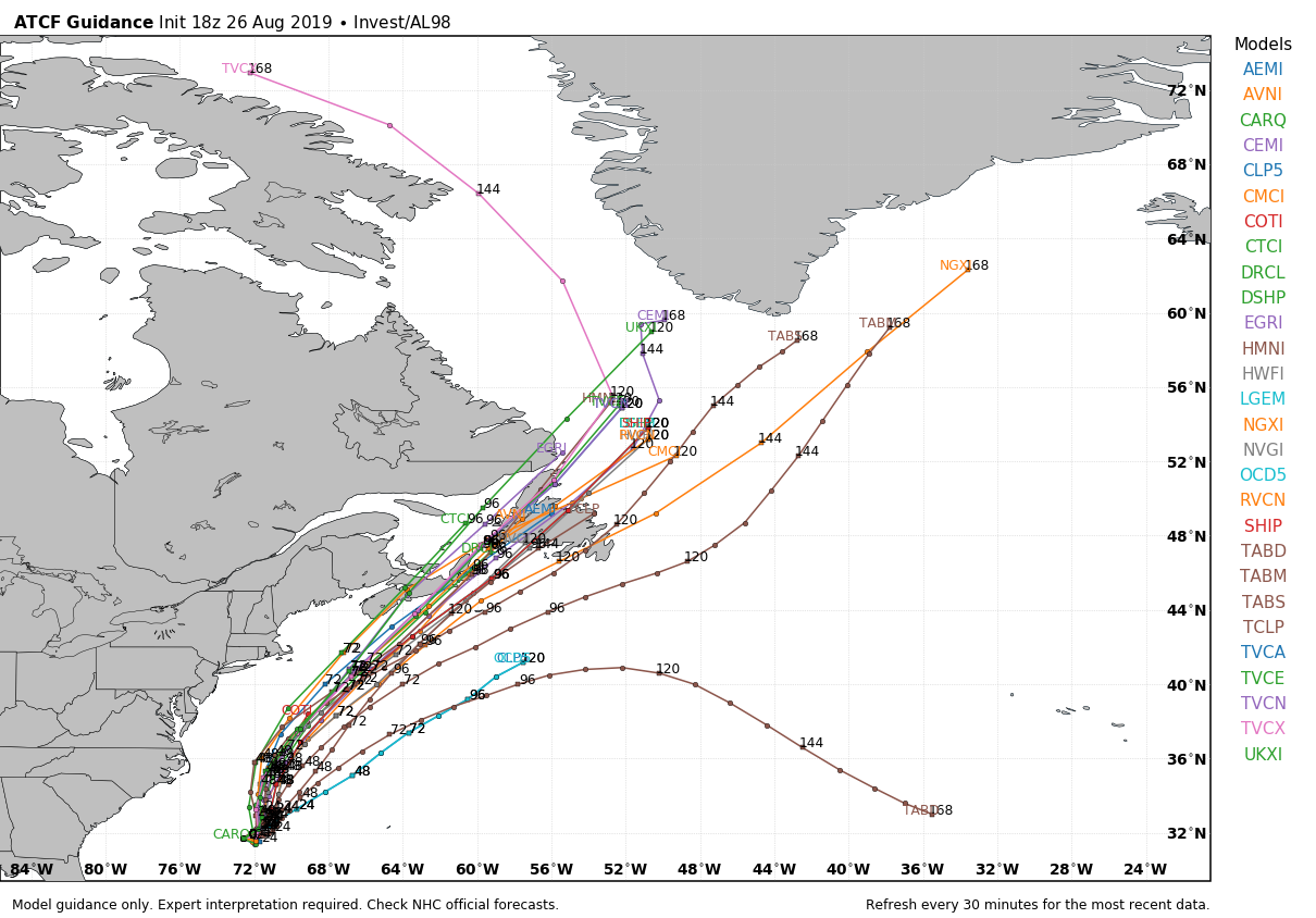
Any potential impacts from Dorian in the Bahamas and Florida later this week are highly uncertain, given the potential for the system to interact with the high terrain of Hispaniola. There is little to no skill in a specific track and intensity forecast of a tropical cyclone beyond seven days; it is unknown whether this system will affect Alabama or the Gulf of Mexico. Output from the European ensemble shows the the uncertainty; various members take the system anywhere from Texas to a recurve path well east of the U.S. Atlantic coast.
The rest of the Atlantic basin is quiet.
ON THIS DATE IN 1992: Hurricane Andrew made a second landfall near Burns Point, Louisiana, as a Category 3 hurricane. Morgan City, Louisiana, recorded sustained winds of 92 mph with a peak gust of 108 mph. Hammond, Louisiana, was deluged with 11.92 inches of rain. As Andrew moved inland and weakened, it spawned 47 tornadoes from this date through Aug. 28 from the South to the Mid-Atlantic states.
BEACH FORECAST: Click here to see the AlabamaWx Beach Forecast Center page.
WEATHER BRAINS: You can listen to our weekly 90-minute show any time on your favorite podcast app. This is the show all about weather featuring many familiar voices, including the meteorologists at ABC 33/40.
CONNECT: You can find me on all of the major social networks:
Facebook
Twitter
Instagram
Pinterest
Snapchat: spannwx
For more weather news and information from James Spann and his team, visit AlabamaWx.


