James Spann: Wet, cold, windy day ahead, with some snow for north Alabama
James Spann forecasts a big change in the Alabama weather from Alabama NewsCenter on Vimeo.
ACTIVE DAY: There’s much to discuss this morning. Just before daybreak, rain was fairly extensive across the northern half of Alabama ahead of a strong cold front that is over the northwest corner of the state. Here are the big weather issues for today.
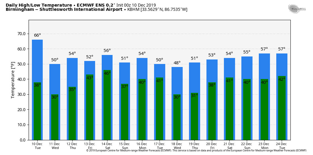
FALLING TEMPERATURES: The high temperature today will come early this morning; many places are in the 65- to 70-degree range over the central part of the state at sunrise. Temperatures will fall through the 60s, 50s, 40s, and we wind up in the 30s by late afternoon. Some places will drop more than 30 degrees in 12 hours. A strong northwest wind of 12-25 mph will make it feel colder, so dress accordingly as you leave this morning.
RAIN: Widespread rain is likely today and early tonight; rain amounts of one-half inch to 1 inch are likely, with isolated heavier amounts. You might hear some thunder this morning, but no severe storms are expected. The rain will end from northwest to southeast tonight as drier air returns.
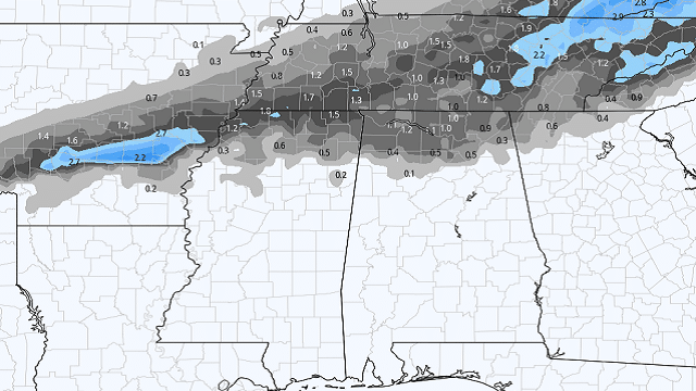
SNOW: As cold air deepens over north Alabama, rain will most likely change to light snow before ending late this afternoon and tonight. The change could come as early as 4 to 6 over the northwest corner of the state, but the main window comes from 6 p.m. until 3 a.m. Snow accumulation potential will be limited by the warm ground, but some grassy areas could see one-half inch to 1 inch in spots north of U.S. 278 (north of a line from Hamilton to Cullman to Gadsden). Roads will be just wet tonight with no travel impact; surface temperatures will be in the mid 30s.
Temperatures drop below freezing after midnight, and if there is any lingering moisture a few icy spots are possible on bridges and overpasses. But the strong northwest wind will dry most roads and bridges, so the overall threat is low, and the National Weather Service Huntsville has opted not to issue a winter weather advisory for now.
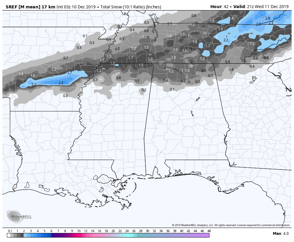
While a few snowflakes are possible as far south as Lamar, Marion, Winston, Fayette, Walker, Cullman, Blount and Marshall counties, no snow is expected over the central part of Alabama tonight.
WEDNESDAY THROUGH FRIDAY: Wednesday will be a mostly sunny day with a high in the mid 50s. The daytime Thursday will be dry, but clouds increase by afternoon as a wave moves out of the Gulf of Mexico. Rain becomes widespread across Alabama Thursday night into part of the day Friday; some thunder is possible, but severe storms are not expected. This will bring another one-half inch to 1 inch to most of the state; the rain should end from west to east Friday afternoon as the low moves northeast, away from Alabama. The high Thursday and Friday will remain in the 50s.
THE ALABAMA WEEKEND: An upper trough will swing through Saturday, but for now the air looks too dry for any meaningful rain. The sky will be occasionally cloudy Saturday with a high close to 60 degrees. Sunday looks dry and mild; with a partly sunny sky the high will be between 65 and 70. Clouds thicken Sunday night.
NEXT WEEK: More rain will move into the state early in the week. For now it looks like the main window for wet weather comes Monday afternoon through Tuesday morning; the latter half of the week will be cool and dry.
ON THIS DATE IN 2012: An EF1 tornado moved through northern Birmingham. The tornado touched down just east of the Birmingham Farmers Market. From there, it moved northeast across a light industrial warehouse area, striking a large metal building. The tornado blew in several overhead doors at the loading dock, then blew about 25 percent of the roof off the building. Debris from this structure was found up to a mile away. The tornado continued northeastward through a residential area, causing damage to 29 homes, two of which had major damage and one of which lost its roof entirely. A church and two businesses were damaged near the intersection of Finley Boulevard and 16th Street. The tornado lifted near the intersection of 24th Court North and 18th Street North, just west of Interstate 65. There were no injuries.
BEACH FORECAST: Click here to see the AlabamaWx Beach Forecast Center page.
WEATHER BRAINS: You can listen to our weekly 90-minute show any time on your favorite podcast app. This is the show all about weather featuring many familiar voices, including the meteorologists at ABC 33/40.
CONNECT: You can find me on the major social networks:
Facebook
Twitter
Instagram
Pinterest
Snapchat: spannwx
For more weather news and information from James Spann and his team, visit AlabamaWx.


