Scott Martin: Alabama stays mostly dry today
NOT A BAD SATURDAY FOR MOST: After a few lingering showers move out, much of the rest of Saturday will be dry across north and central Alabama. Skies will remain partly to mostly cloudy, and highs will be in the upper 50s in the northwest to nearly touching 80 degrees in the southeast.

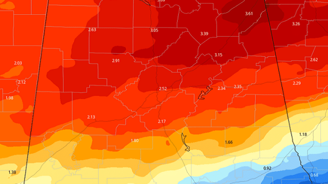
EXPECTED RAINFALL THROUGH MIDDAY FRIDAY: Rainfall from now through midday Friday looks to range from just over one-half inch in the extreme southeastern part of the state to more than 3-1/2 inches in the northeastern part. The good news is that we have not had that much rainfall over the past week, allowing the ground to dry out just a little, but we may have to watch for some localized flooding by Wednesday if this pans out.
RAIN RETURNS SUNDAY: Unfortunately, it looks like rain returns to the forecast on Sunday as rain chances increase from the southwest and south throughout the day. Rain will be likely at any time, but it will not rain all day. Some thunder will be possible, but nothing strong is expected. Highs reach the upper 50s to the mid-70s from north to south.
RAIN POSSIBLE AT TIMES THROUGH MIDWEEK: Rain will continue to be likely at times on Monday, but those rain chances will begin to fall for the northern half of Alabama by the evening and late-night hours. Some thunder will be possible, and I wouldn’t be surprised if we see a strong storm or two, but the overall severe weather threat is really low. Highs will be back up into the mid-60s to the mid-70s.

The active pattern continues Tuesday as scattered showers and a few thunderstorms will be likely over northern Alabama, while rain chances drop quickly as you move south. At this point, there is a good chance that locations along and south of I-85 stay dry. We may have to watch for a few strong to marginally severe storms over the northern half of the state, as it looks like we’ll have a good bit of instability in place along with a good bit of shear during the afternoon and evening. Strong winds look to be the main threat at this point, but we cannot rule out a brief tornado with this setup. We’ll keep an eye on this over the next few days to see what the convection-allowing models have to say. Highs will be in the lower 70s to the lower 80s.
The good news is that much of the thunderstorm activity will be out of the state on Wednesday morning, but we could see a few isolated to scattered showers over central and southern Alabama, while north Alabama looks to get a chance to dry out. Highs will be in the lower 70s to the lower 80s.
DRY, WARM TO END THE WORK WEEK: Thursday looks to be a mainly dry day across north and central Alabama, but we could see an isolated shower or two over the northern parts of the state during the main heating of the day. A few showers may be possible during the evening to late night for the northern locations, but the rest of the nighttime hours look to stay dry. Highs will be in the upper 70s to the upper 80s.
Friday looks to be another fantastic, warm day, but rain and thunderstorms may invade the extreme northern portions of Alabama during the afternoon and evening. The rest of Alabama stays dry, and highs reach the mid-70s to the upper 80s.
For more weather news and information from James Spann, Scott Martin and other members of the James Spann team, visit AlabamaWx.


