James Spann: Strong to severe storms possible in Alabama Wednesday
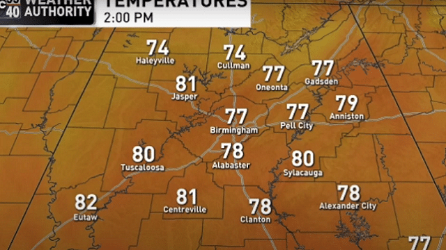
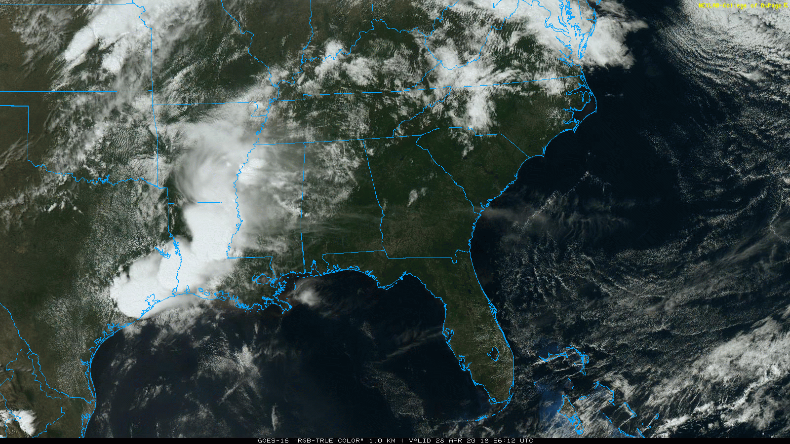
WARM AFTERNOON: Temperatures have reached the low 80s across parts of north and central Alabama this afternoon with a mix of sun and clouds. The average high for Birmingham on April 28 is 77. Clouds will increase tonight ahead of a storm system to the west of Alabama; a line of severe storms with a high probability of damaging winds will develop in coming hours over east Oklahoma and northeast Texas.
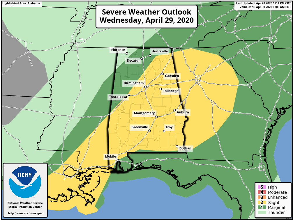
ACTIVE DAY WEDNESDAY: The Storm Prediction Center has a big chunk of Alabama in a slight risk (level 2 out of 5) of severe thunderstorms Wednesday.
The line of storms to the west is expected to weaken considerably after midnight, and a band of showers with gusty winds will push into west Alabama early Wednesday morning, most likely between 5 and 6. Odds of severe weather during the morning are low.
But by afternoon the air becomes unstable, and as a cold front pushes into the state a new band of showers and thunderstorms will develop, roughly along I-59. These storms will move eastward and will be capable of producing strong, gusty winds and some small hail. An isolated tornado can’t be ruled out but isn’t likely. Rain amounts of one-half inch to 1 inch are likely, and for now major flooding is not expected.
The main window for strong to severe storms will come from roughly noon until 6 p.m. While this certainly doesn’t look like a major severe weather event, you always have to be very weather aware in late April. Be sure you have a way of hearing severe weather warnings in the event they are needed.
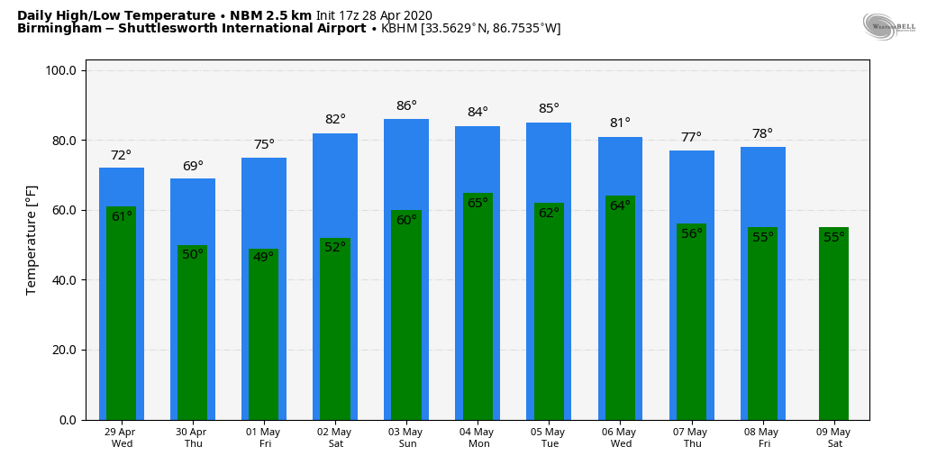
THURSDAY THROUGH THE WEEKEND: The sky becomes partly to mostly sunny Thursday, although clouds could linger over northeast Alabama much of the day. Thursday will be cooler, with a high between 68 and 72 degrees. On Friday, after a low in the 40s we rise into the mid 70s with sunshine in full supply. It will be a delightful spring day.
We project this weekend to be the warmest so far this year in Alabama. The sky will remain mostly sunny both days; we are forecasting a high in the low 80s Saturday and mid 80s Sunday.
NEXT WEEK: New global model guidance shows a surface front moving into the state Monday with some risk of showers, followed by another chance of showers Tuesday night or Wednesday. For now both events look like they will bring only light precipitation amounts to the state. Cooler, drier air rolls in Thursday and Friday.
ON THIS DATE IN 2014: A total of 28 tornadoes touched down across north and central Alabama, including EF-2 twisters that moved through parts of Adamsville, Graysville and Bessemer. An EF-1 touched down north of Birmingham at Kimberly. Two people were killed by an EF-3 tornado that night at a mobile home community in Limestone County. Another EF-3 in Russell County in east Alabama was responsible for 13 injuries.
ON THIS DATE IN 2002: During the evening, a violent F4 tornado carved a 64-mile path across southeast Maryland. The La Plata, Maryland, tornado was part of a larger severe weather outbreak that began in the mid-Mississippi Valley early that day and spread across portions of the Ohio Valley and the Mid-Atlantic states. In Maryland, three deaths and 122 injuries were a direct result of the storm. Property damage exceeded $100 million.
WEATHER BRAINS: You can listen to our weekly 90-minute show any time on your favorite podcast app. This is the show all about weather featuring many familiar voices, including the meteorologists at ABC 33/40.
CONNECT: You can find me on all of the major social networks:
Facebook
Twitter
Instagram
Pinterest
Snapchat: spannwx
For more weather news and information from James Spann and his team, visit AlabamaWx.


