James Spann: Hot, humid day for Alabama, with a few afternoon storms
James Spann forecasts classic summer weather for Alabama this week from Alabama NewsCenter on Vimeo.
CLASSIC SUMMER WEATHER: This is the time of the year when our weather doesn’t change much. Days are hot and humid with a partly sunny sky, and during the peak of the daytime heating we see a handful of showers and thunderstorms in random, scattered locations. That will be the situation this week across Alabama; odds of any one spot getting wet are around 1 in 5, and mostly between 1 and 9 p.m.
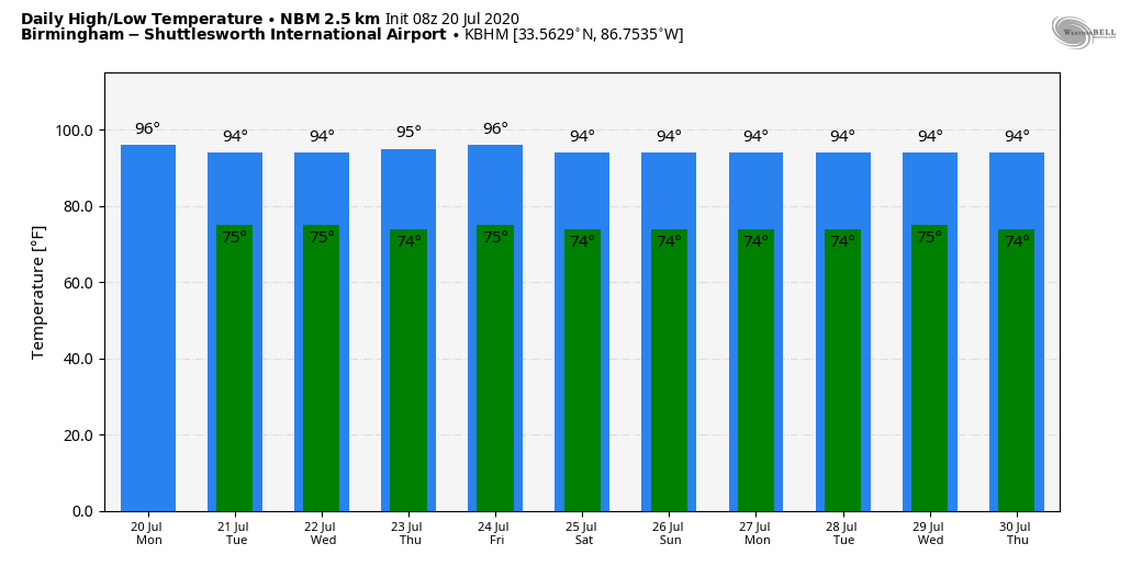
Models suggest moisture will be a bit deeper Tuesday and Wednesday, with some increase in the number of showers and storms during the afternoon and evening hours, but they will still be scattered, and not everyone will see rain. Highs through the week will be mostly in the 93- to 97-degree range, with lows in the 70s.
THE ALABAMA WEEKEND AND NEXT WEEK: An upper ridge will remain in place across the southern U.S. and the overall pattern won’t change. Look for hot, humid days, a partly sunny sky and scattered, mostly afternoon and evening showers and thunderstorms. Highs will remain in the 90s, with lows in the 70s. Good ol’ summertime weather in Alabama.
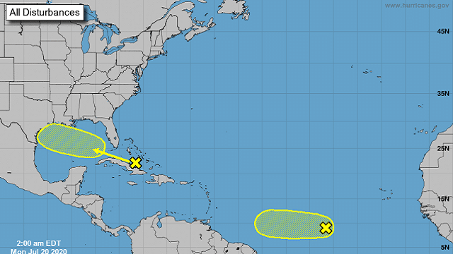
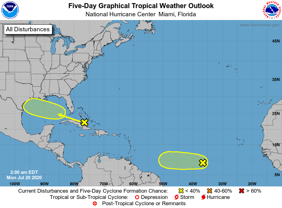
TROPICS: Out in the deep tropics, a wave more than 900 miles west-southwest of the Cabo Verde Islands is producing a small area of disorganized showers and thunderstorms. Environmental conditions are expected to be marginally conducive for development of this system during the next few days while it moves westward at 10 to 15 mph over the tropical Atlantic. By Friday and over the weekend, conditions are forecast to become less favorable for tropical cyclone formation.
Closer to home, disorganized showers and thunderstorms over the central Bahamas, central Cuba and adjacent Atlantic waters are associated with a tropical wave. Environmental conditions could become a little more conducive for development of this system over the Gulf of Mexico. This system is expected to move west-northwestward through the Straits of Florida today, over the southeastern Gulf of Mexico Tuesday, across the central Gulf on Wednesday and to reach the northwestern Gulf on Thursday. The National Hurricane Center gives this a 20% chance of becoming a tropical depression or storm; one way or another it could bring beneficial rain to parts of Texas in five days or so. Most likely it remains south of Alabama and the Central Gulf Coast.
ON THIS DATE IN 1977: A flash flood hits Johnstown, Pennsylvania, killing 84 people and causing millions of dollars in damages. This flood came 88 years after the infamous Great Flood of 1889 that killed more than 2,000 people in Johnstown.
ON THIS DATE IN 2005: Hurricane Emily made landfall in northern Mexico. When sustained winds reached 160 mph on July 16, Emily became the strongest hurricane ever to form before August, breaking a record set by Hurricane Dennis just six days before. It was also the earliest Category 5 hurricane ever recorded in the Atlantic basin, beating Hurricane Allen’s old record by nearly three weeks.
BEACH FORECAST: Click here to see the AlabamaWx Beach Forecast Center page.
WEATHER BRAINS: You can listen to our weekly 90-minute show anytime on your favorite podcast app. This is the show all about weather featuring many familiar voices, including the meteorologists at ABC 33/40.
CONNECT: You can find me on all of the major social networks:
Facebook
Twitter
Instagram
Pinterest
Snapchat: spannwx
For more weather news and information from James Spann and his team, visit AlabamaWx.


