James Spann: Moisture levels rise, showers return to Alabama today
James Spann has the Alabama forecast for midweek from Alabama NewsCenter on Vimeo.
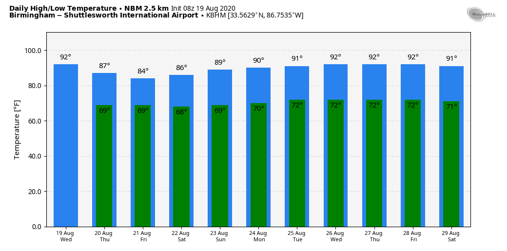
RAIN CHANCES INCREASING: Moisture levels will rise across Alabama today, and we expect scattered showers and thunderstorms to form this afternoon and tonight, generally after 1 p.m. The chance of any one spot getting wet is 30-40%; otherwise, the sky will be partly sunny today with a high between 88 and 91 degrees. The average high for Birmingham on Aug. 19 is 91.
Thursday and Friday will be unsettled, with scattered to numerous showers and thunderstorms both days. Look for more clouds than sun with highs in the mid 80s. While most of the showers will come during the afternoon and evening hours, we can’t rule out a few late-night or morning showers as well.
THE ALABAMA WEEKEND: The sky will be occasionally cloudy Saturday with a couple of showers or storms likely, but the weather trends drier Sunday, with only widely scattered showers and a partly sunny sky. The high will be in the mid 80s Saturday, then in the 87- to 90-degree range Sunday.
NEXT WEEK: Our weather will all depend on potential tropical development in the Gulf of Mexico, and right now there is no way of knowing exactly how that scenario plays out. So, for now, we will roll with a summer persistence forecast through the weekend — partly sunny days with scattered, mostly afternoon and evening showers and thunderstorms and highs at or just over 90 degrees. Just be aware that the forecast will probably change a good bit in coming days.
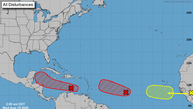
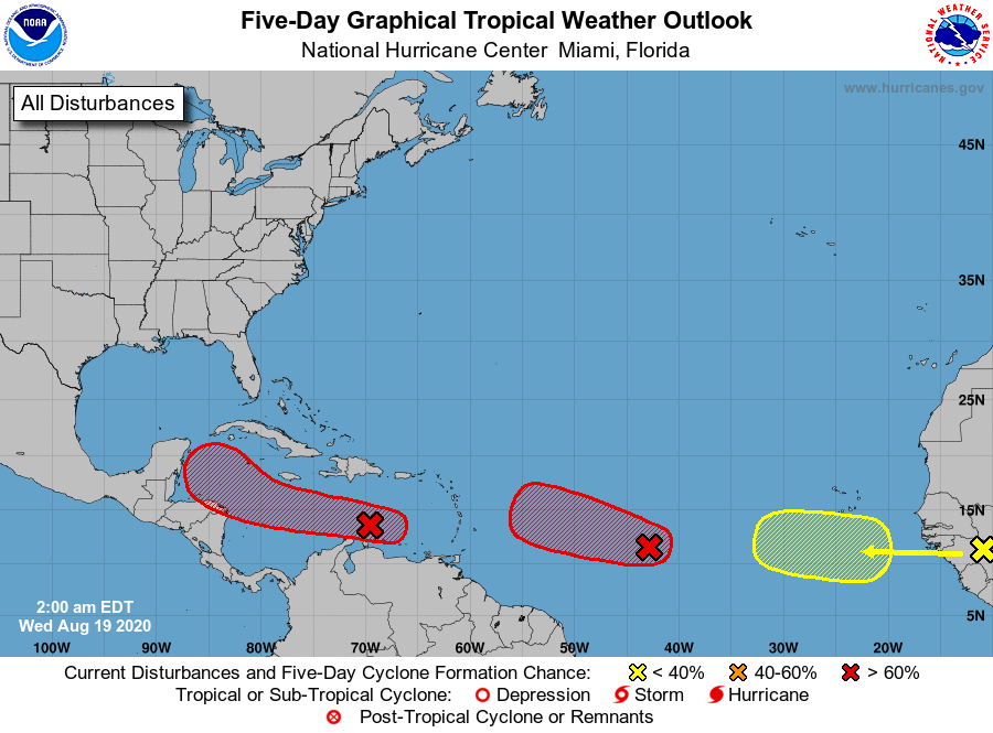
TROPICS: There are now three well-organized tropical waves to watch in the Atlantic basin. One will emerge off the African coast within the next 24 hours, another is in the middle of the Atlantic between the Lesser Antilles and the coast of Africa, and the third is in the Caribbean.
The wave over Africa is producing a large area of showers and thunderstorms over Guinea and is associated with a vigorous tropical wave. Environmental
conditions are expected to be marginally conducive for some development of this system while the wave enters the extreme eastern Atlantic on Friday. By early next week, however, conditions are forecast to become less favorable for tropical cyclone formation while it moves west-northwestward at 15 to 20 mph toward the central tropical Atlantic.
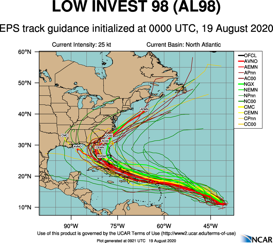
INVEST 98L: The wave over the Central Atlantic is a little more than 1,000 miles east of the Windward Islands and continues to produce a concentrated area of showers and thunderstorms mainly on the west side of the disturbance. Environmental conditions are conducive for further development, and a tropical depression is expected to form during the next day or two while the system moves generally west-northwestward at 15 to 20 mph across the central and western portions of the tropical Atlantic. Long-range model data suggests this could be close to the Florida Peninsula in seven to 10 days, but there is no way of knowing the ultimate track or intensity at this point. I would say odds are fairly high this one recurves into the mid-latitude westerlies east of Alabama.
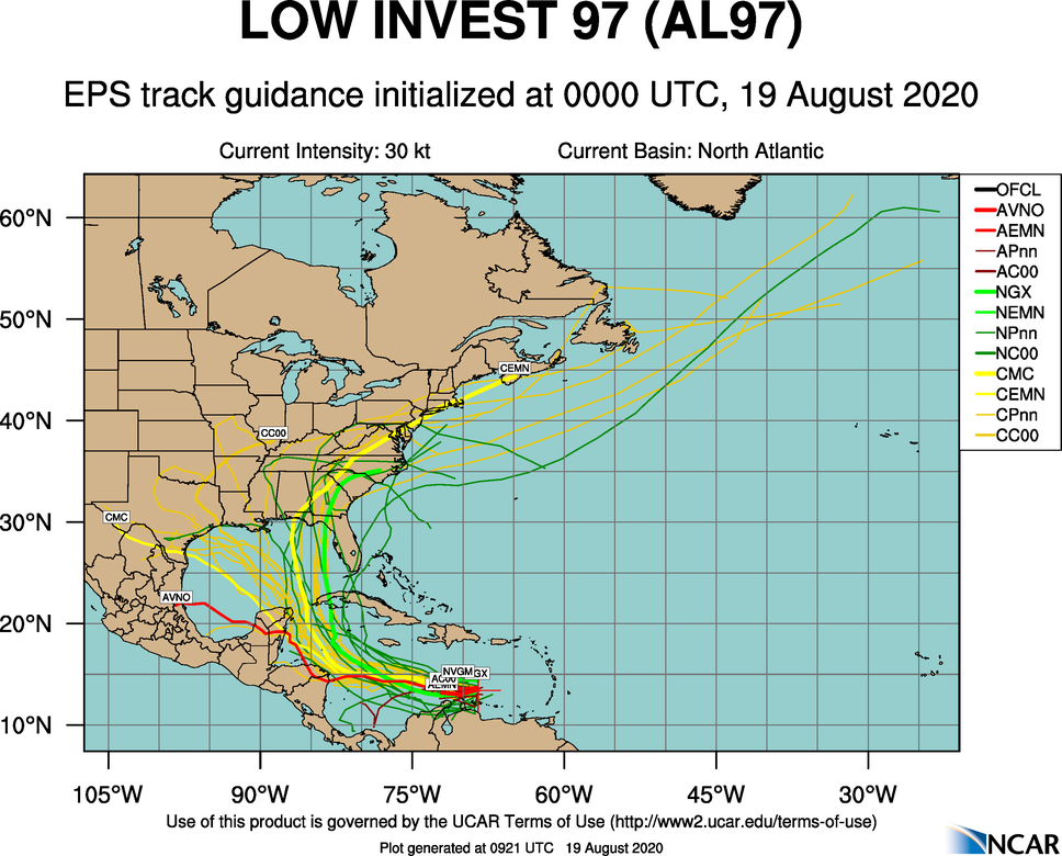
INVEST 97L: This tropical wave is over the eastern Caribbean Sea and is producing disorganized showers and thunderstorms along with gusty winds. Significant development of this system is unlikely during the next day or so while it moves quickly westward at about 20 mph across the eastern and central Caribbean Sea. After that time, however, the wave is forecast to move more slowly west-northwestward, and a tropical depression is likely to form late this week or this weekend when the system reaches the northwestern Caribbean Sea.
There is a pretty good chance this reaches the Gulf of Mexico in four to five days, but it could wind up anywhere from Mexico to Florida. Again, it’s just too early to call.
The Gulf of Mexico will remain quiet this week.
ON THIS DATE IN 1991: Hurricane Bob made landfall twice in Rhode Island as a Category 2 hurricane, first on Block Island and then in Newport. Upon doing so, it became the only hurricane to make landfall in the contiguous United States during the 1991 season. Bob was one of the costliest hurricanes in New England history; it left extensive damage throughout New England in its wake, totaling approximately $1.5 billion (in 1991 dollars). This made it one of the costliest United States hurricanes at the time. In addition, 18 fatalities were reported in association with Bob. The loss of life and most of the damage occurred as a result of high winds and rough seas. There were six confirmed tornadoes during its passage.
BEACH FORECAST: Click here to see the AlabamaWx Beach Forecast Center page.
WEATHER BRAINS: You can listen to our weekly 90-minute show anytime on your favorite podcast app. This is the show all about weather featuring many familiar voices, including the meteorologists at ABC 33/40.
CONNECT: You can find me on the major social networks:
Facebook
Twitter
Instagram
Pinterest
Snapchat: spannwx
For more weather news and information from James Spann and his team, visit AlabamaWx.


