James Spann: Periods of rain for Alabama today; Laura now a hurricane

James Spann forecasts growing intensity for Laura from Alabama NewsCenter on Vimeo.
WET DAY: Rain is fairly widespread over the southern two-thirds of Alabama this morning and continues to move northward. Today will be cloudy with periods of rain; many places will hold in the 70s most of the day with very little sun.
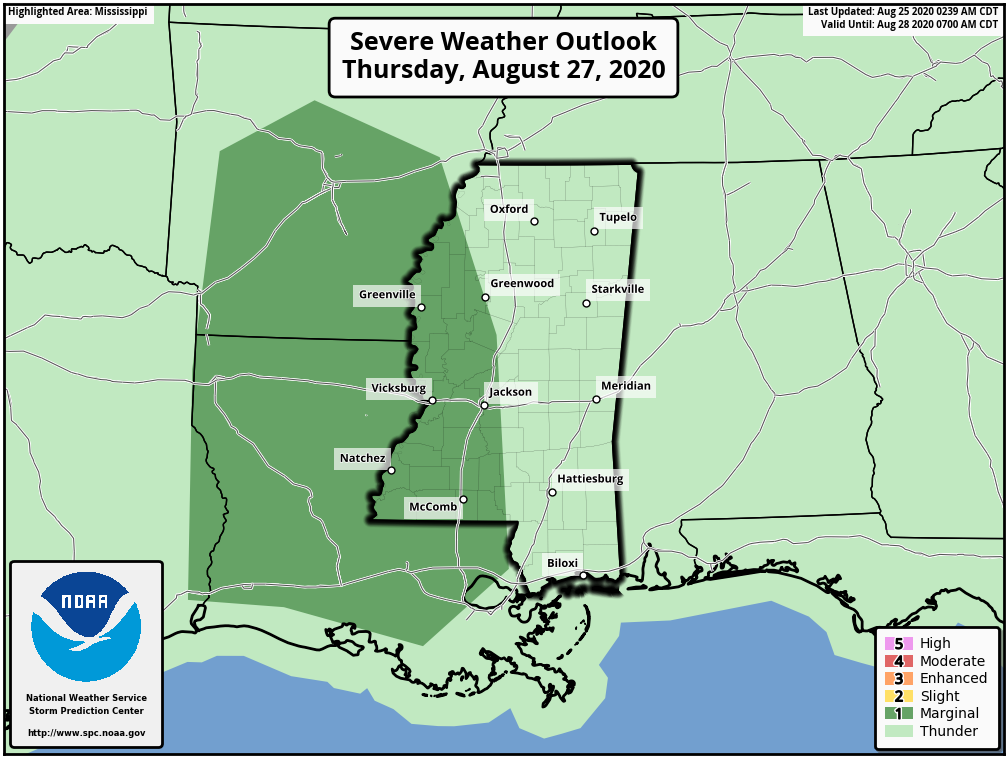
Showers will become more scattered Wednesday with a mix of sun and clouds as we get into sinking air on the periphery of Laura, which became a hurricane this morning in the northwest Gulf of Mexico. On Thursday the sky will be partly sunny with temperatures potentially reaching the low 90s. This will make the air pretty unstable, and we will see a few scattered storms by mid to late afternoon. Laura will be passing well to the west over western Louisiana and Arkansas. For now it looks like the main threat of isolated tornadoes will be west of Alabama, but we will need to keep a close eye on radar Thursday evening for any signs of rotation with scattered storms that develop. The Storm Prediction Center has a marginal risk (level 1 of 5) defined for parts of Mississippi, Arkansas and Louisiana Thursday.
FRIDAY AND THE WEEKEND: Laura will pull a very moist, tropical air mass into Alabama. The sky will feature more clouds than sun on these three days with occasional showers and a few thunderstorms likely. It won’t be a total washout, but the pattern will be pretty wet. Highs Friday and over the weekend will be in the mid to upper 80s.
NEXT WEEK: We expect scattered to numerous showers and thunderstorms the first half of the week. A surface front will approach by midweek, but most likely it won’t have enough southward push to make it through Alabama.
LAURA BECOMES A HURRICANE: Laura is about 680 miles southeast of Lake Charles, Louisiana, in the Gulf of Mexico. It became a hurricane this morning with maximum sustained winds of 75 mph and higher gusts. The new National Hurricane Center forecast puts landfall near the Sabine Pass (the Texas/Louisiana border) Wednesday night as a major Category 3 hurricane. A Hurricane Watch is in effect from San Luis Pass, Texas, to west of Morgan City, Louisiana; Hurricane Warnings will be required by late afternoon.
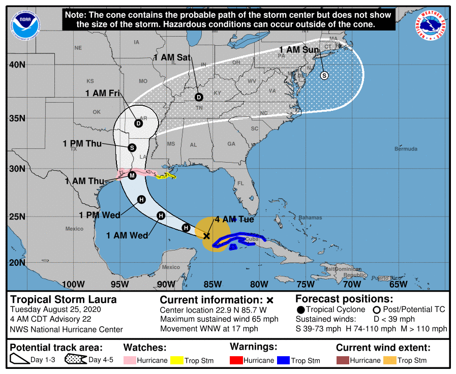
Now that an inner core appears to be trying to form, conditions appear ripe for at least steady intensification, and rapid intensification is becoming more likely before landfall. In fact, almost all of the explicit guidance models, save the statistical-dynamical models, are showing a period of rapid strengthening at some point during the next couple of days.
Key messages from the NHC:
- Laura is forecast to reach the northwestern Gulf Coast as a hurricane late Wednesday and early Thursday. Do not focus on the details of the official forecast given the typical uncertainty in the NHC’s two- to three-day track and intensity predictions. In addition, storm surge, wind and rainfall hazards will extend well away from Laura’s center along the Gulf Coast.
- There is a risk of life-threatening storm surge from San Luis Pass, Texas, to Ocean Springs, Mississippi, within the next 48 hours, and a storm surge watch is in effect for these areas outside of the southeast Louisiana Hurricane and Storm Damage Risk Reduction System. Residents in these areas should follow any advice given by local officials.
- Hurricane conditions are possible by late Wednesday from San Luis Pass, Texas, to west of Morgan City, Louisiana, with tropical storm conditions possible by Wednesday afternoon, and a Hurricane Watch is in effect. Hurricane Warnings will likely be issued for a portion of that area later today.
- The threat of widespread flash and urban flooding, along with small streams overflowing their banks, will increase Wednesday night into Thursday from far eastern Texas across Louisiana and Arkansas. This will also lead to minor to isolated moderate river flooding. The heavy rainfall threat will spread northeastward into the middle Mississippi, lower Ohio and Tennessee Valleys Friday and Saturday.
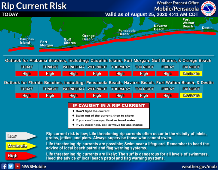
CENTRAL GULF COAST: The rip current danger will remain high along the coast from Gulf Shores east to Panama City Beach through Friday; seas will settle down this weekend.
The main impact from Laura will remain west of the Alabama/Northwest Florida Gulf Coast this week.
ON THIS DATE IN 1992: After making landfall over south Florida as a devastating Category 5 hurricane, Andrew emerged into the Gulf of Mexico, moving in the direction of the Louisiana coast. The second landfall came after midnight about 20 miles west-southwest of Morgan City, with winds of 115 mph. Andrew weakened rapidly as it turned to the north and northeast, falling to tropical storm intensity within 10 hours. Along the Louisiana coastline, damages largely resembled those of a Category 2 hurricane. Damage was heaviest in St. Mary Parish, about 32 miles east of where Andrew made landfall.
BEACH FORECAST: Click here to see the AlabamaWx Beach Forecast Center page.
WEATHER BRAINS: You can listen to our weekly 90-minute show anytime on your favorite podcast app. This is the show all about weather featuring many familiar voices, including the meteorologists at ABC 33/40.
CONNECT: You can find me on the major social networks:
Facebook
Twitter
Instagram
Pinterest
Snapchat: spannwx
For more weather news and information from James Spann and his team, visit AlabamaWx.


