James Spann: Wet, stormy day ahead for Alabama
James Spann forecasts a rainy day in Alabama from Alabama NewsCenter on Vimeo.
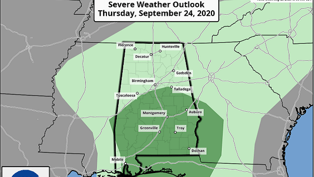
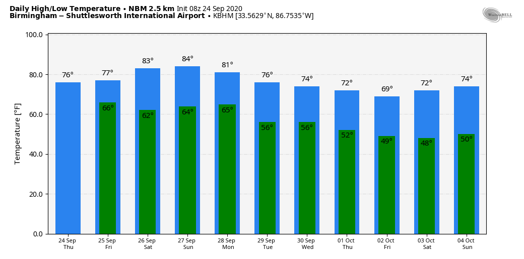
GHOST OF BETA: The remnants of former Tropical Storm Beta will bring lots of rain and a few thunderstorms to Alabama today. A Flash Flood Watch is in effect for the Tennessee Valley of north Alabama, where rain amounts could exceed 2 inches in spots. The Storm Prediction Center maintains a marginal risk (level 1 out of 5) of severe thunderstorms for the southern two-thirds of the state.
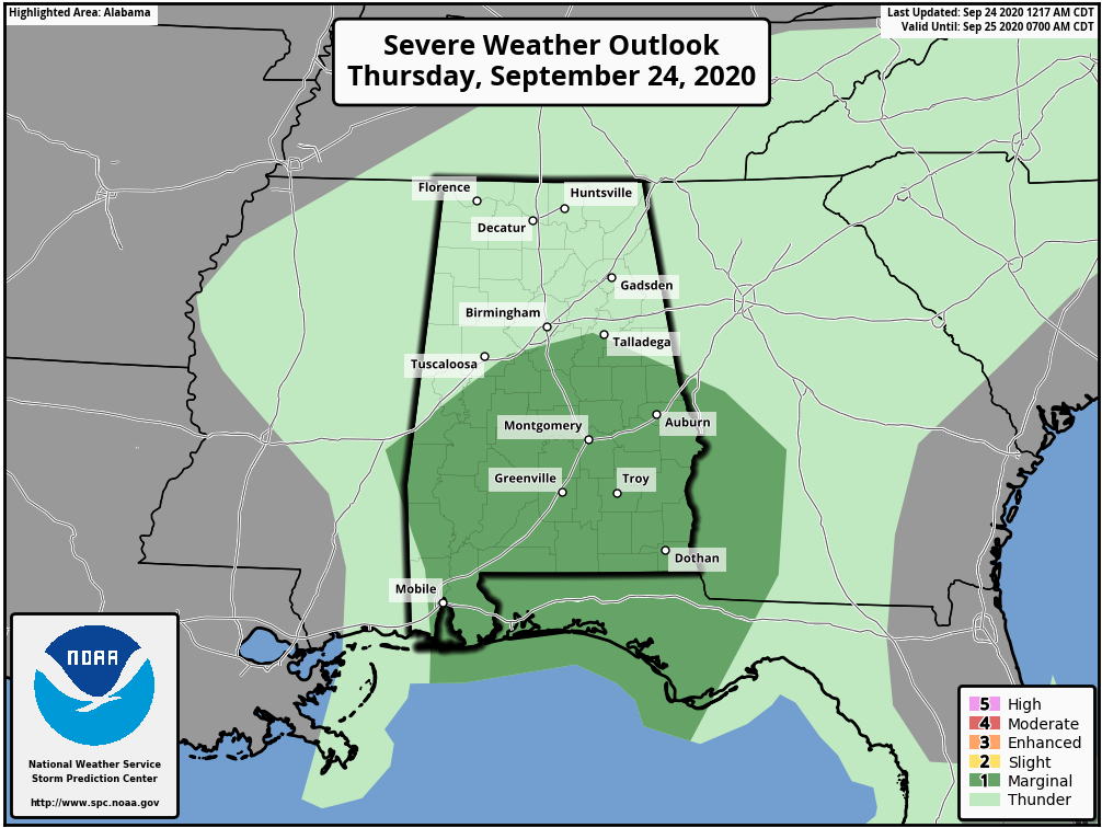
A few storms south of I-20 this afternoon could produce gusty winds, and there is also the potential for one or two brief, isolated tornadoes. Just be weather aware today in case a few warnings are required. Severe storms are not expected over north Alabama because the air will be too stable. Rain will taper off from west to east tonight.
FRIDAY AND THE WEEKEND: Friday and Saturday will be generally dry and warmer. We will see a mix of sun and clouds Friday with only isolated showers; the high will be close to 80 degrees. On Saturday, temperatures rise into the mid-80s with a good supply of sunshine. The chance of any one spot seeing a shower is 20% Friday and 10% Saturday. Moisture will surge northward Sunday, and scattered showers and storms return to the state, especially during the afternoon and evening. Sunday’s high will be in the mid-80s.
NEXT WEEK: We will maintain the chance of scattered showers Monday ahead of a cold front, which will likely pass through Monday night or early Tuesday. Cooler, drier air returns for the latter half of the week, with highs around 70 and lows in the upper 40s and low 50s.
FOOTBALL WEATHER: UAB travels to Mobile to take on South Alabama Thursday night (6:30 kickoff). The sky will be mostly fair with temperatures falling from the low 80s at kickoff into the upper 70s by the final whistle.
For the high school games Friday night, the risk of a shower for any one specific stadium looks small. Temperatures will fall slowly into the mid to upper 70s.
Saturday, Auburn will host Kentucky at Jordan Hare Stadium (11 a.m. kickoff). Expect a partly sunny sky with only a small risk of a brief shower. Temperatures will rise into the low 80s during the game.
Alabama travels to Columbia, Missouri, to take on Mizzou Saturday (6 p.m. kickoff). The sky will be clear, with temperatures falling from near 82 at kickoff through the 70s during the second half.
TROPICS: The Atlantic basin is quiet for a change; no tropical storms are forecast for the next five days.
ON THIS DATE IN 2005: Rita made landfall as a Category 3 hurricane in Johnson’s Bayou, Louisiana, between Sabine Pass, Texas, and Holly Beach, Louisiana, with winds of 115 mph. Hurricane Rita was the most intense tropical cyclone on record in the Gulf of Mexico prior to weakening before landfall, and the fourth-most intense Atlantic hurricane ever recorded. Part of the record-breaking 2005 Atlantic hurricane season, which included three of the 10 most intense Atlantic hurricanes ever recorded (along with No. 1 Wilma and No. 7 Katrina), Rita was the 17th named storm, 10th hurricane and fifth major hurricane of the 2005 season.
BEACH FORECAST: Click here to see the AlabamaWx Beach Forecast Center page.
WEATHER BRAINS: You can listen to our weekly 90-minute show anytime on your favorite podcast app. This is the show all about weather featuring many familiar voices, including the meteorologists at ABC 33/40.
CONNECT: You can find me on the major social networks:
Facebook
Twitter
Instagram
Pinterest
Snapchat: spannwx
For more weather news and information from James Spann and his team, visit AlabamaWx.


