James Spann: Alabama stays mostly dry through early next week; still watching Eta
James Spann forecasts a quiet weather weekend for Alabama from Alabama NewsCenter on Vimeo.
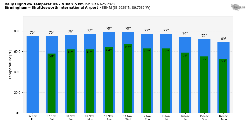
QUIET PATTERN CONTINUES: Alabama’s weather will stay mostly dry through the weekend, although a few isolated showers are possible Saturday over the southern half of the state. Days will be partly sunny, nights mostly fair, and highs will remain generally in the 70s. A few spots over west Alabama could touch 80 Sunday afternoon. Lows over the weekend will be in the low 60s.
NEXT WEEK: Monday still looks dry for most of the state, but we will bring in some risk of showers beginning Tuesday and lasting through the end of the week. The showers should be fairly scattered in nature during midweek, and rain coverage at the end of the week will all depend on the behavior of Tropical Storm Eta, which will be in the Gulf of Mexico. Highs will hold in the 70s through the week.
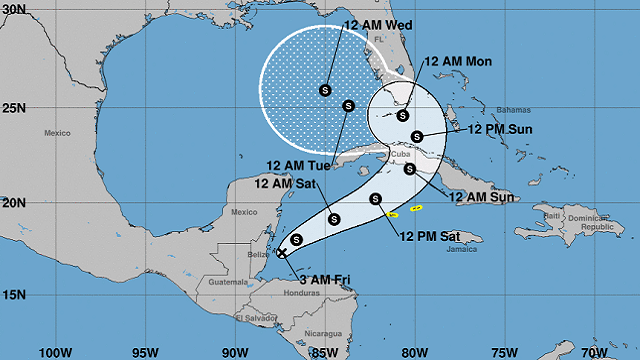
TROPICS: Eta is now back over the Caribbean after a journey through Central America and is expected to become a tropical storm later this morning. The latest National Hurricane Center forecast takes the system over Cuba Sunday, and then it takes a left turn, moving into the southern Gulf of Mexico Monday.
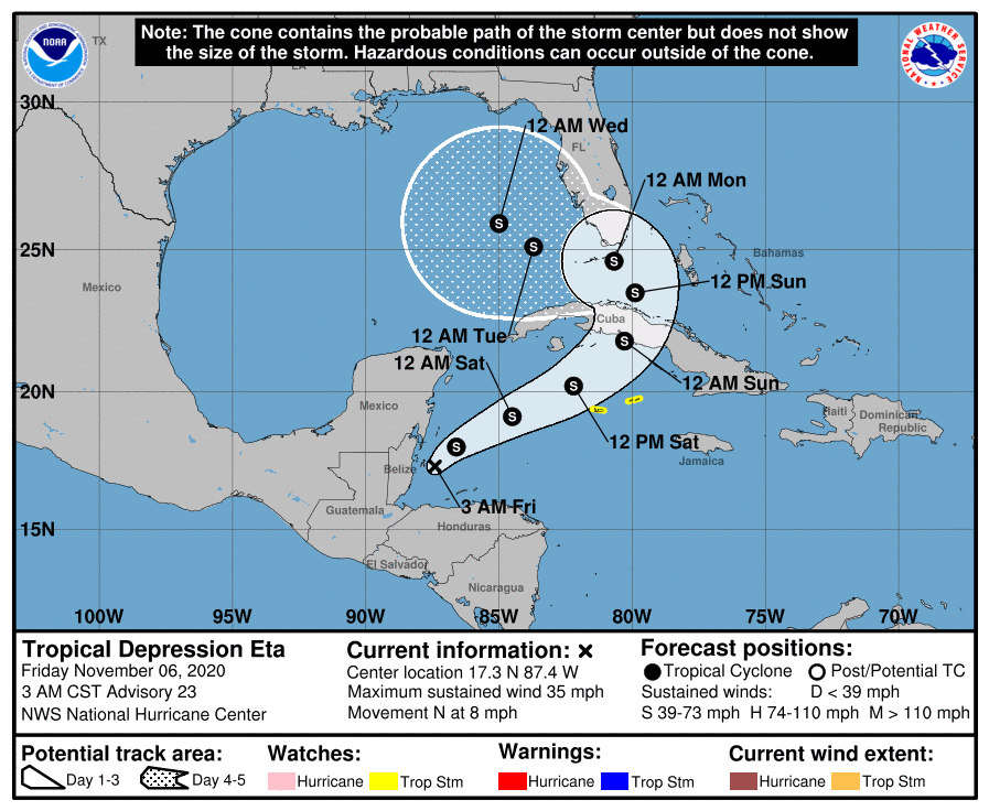
The impact, if any, on the central Gulf Coast remains unclear. Eta could turn northeast, affecting mainly the Florida Peninsula, or it could drift northward toward the Panhandle. Sea water temperatures continue to cool over the northern Gulf, and the main impact will be from heavy rain, most likely, along the track. We will have much better clarity on the ultimate destination of the system over the weekend.
The rest of the Atlantic basin is quiet; hurricane season ends Nov. 30.
ON THIS DATE IN 1977: The Kelly Barnes Dam above the Toccoa Falls Bible College near Toccoa, Georgia, failed in the early morning. Thirty-nine people died in the resulting flood, which inundated part of the campus, including a trailer park.
ON THIS DATE IN 2005: The deadliest tornado to strike Indiana since April 3, 1974, occurred around 2 a.m. A single EF3 tornado inflicted 24 fatalities, 238 injuries and nearly $90 million in damage with a path length of 41 miles. This storm moved in a northeasterly direction from just north of Smith Mills, Kentucky, to Gentryville, Indiana, and crossed the Ohio River three times. Most of the damage occurred as the tornado passed southeast of Evansville, Indiana.
BEACH FORECAST: Click here to see the AlabamaWx Beach Forecast Center page.
WEATHER BRAINS: You can listen to our weekly 90-minute show anytime on your favorite podcast app. This is the show all about weather featuring many familiar voices, including the meteorologists at ABC 33/40.
CONNECT: You can find me on the major social networks:
Facebook
Twitter
Instagram
Pinterest
Snapchat: spannwx
For more weather news and information from James Spann and his team, visit AlabamaWx.


