Scott Martin: Dry Saturday for Alabama with plenty of sun; cloudy Sunday

THE ALABAMA WEEKEND: Today will be an overall nice day with mostly sunny skies. Afternoon highs will range from the lower 70s in the north to the mid-70s in the south and southeast.
Sunday will be much different. Clouds will build throughout the day, and a front begins to sweep through the state late in the day. A few showers may roll into central Alabama during the evening and late night, but those chances will be very small. Afternoon highs will be in the upper 60s to the mid-70s from north to south.
THANKSGIVING WEEK: High pressure quickly builds behind the front on Monday and brings nice and much cooler weather to Alabama. Temperatures will range from the lower 60s in the northwest to the lower 70s in the southeast.
Another system will start to get its act together to our west on Tuesday and will begin to head in our direction. We’ll stay dry through nearly the entire day, but a stray shower may be possible around or just after midnight. Skies will start the day mostly sunny, but clouds associated with the system will move in late. Highs will be in the mid-60s to the lower 70s from northwest to southeast.
Wednesday may be a day we have to watch as a warm front moves up through Alabama ahead of an approaching cold front. At this point there doesn’t appear to be a severe weather threat, as instability values do not look all that impressive. But we will have a decent bit of shear in place, so it may not take that much instability to get something fired up. We’ll keep you updated. For now, I’ll go with scattered showers and thunderstorms possible throughout the day, with the potential of one or two strong storms. Afternoon highs will be in the mid-60s to the mid-70s from northwest to southeast.
The cold front appears to wash out across south-central Alabama, and that will keep a few showers in the forecast for the southern half of the state on Thursday. The northern half will have a little drier air with mostly sunny skies. Afternoon highs will be in the mid-60s to the lower 70s.
Moisture looks to make its way back up into the state for the latter half of Friday, bringing a small chance of showers and maybe a thunderstorm. Skies will be mostly cloudy and highs will be in the mid-60s to the lower 70s.
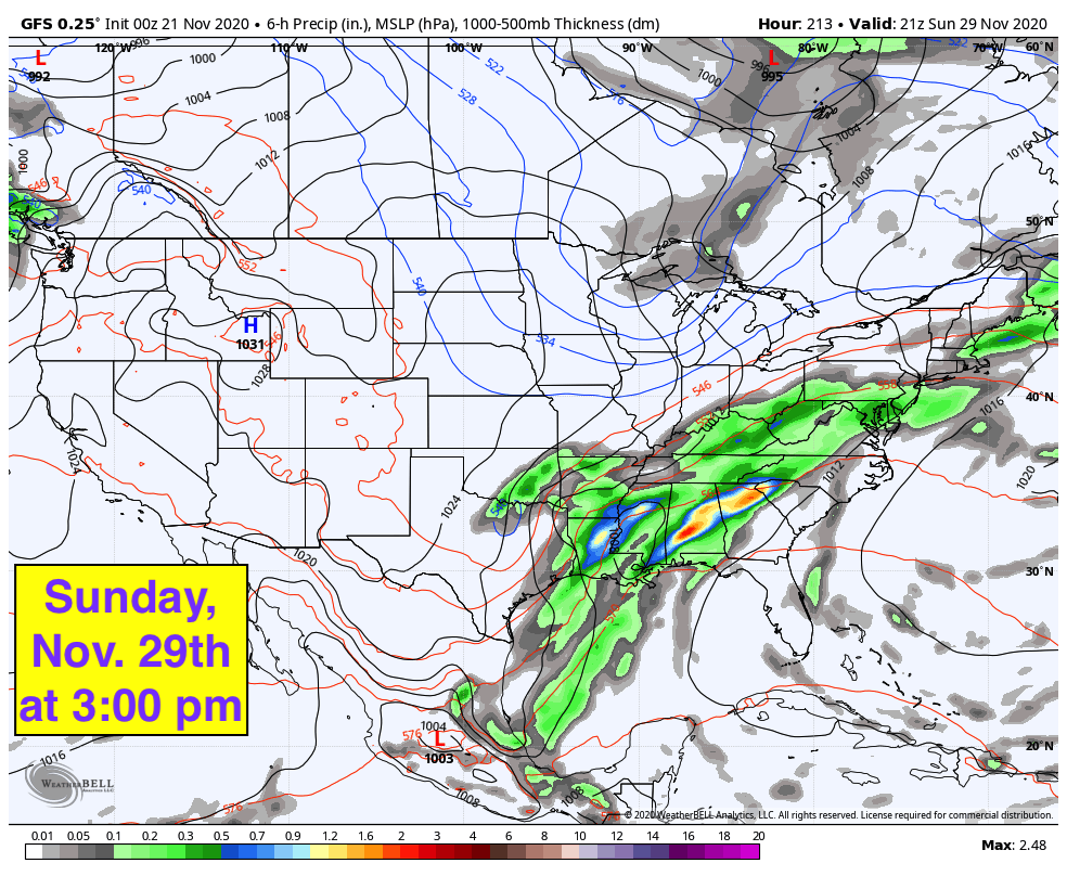
VOODOO LAND: This moisture will stick around through the weekend (Nov. 28-29) and will bring rain on both Saturday and Sunday. Rain on Sunday looks to be heavy at times, with 24-hour rainfall totals projected by the Global Forecast System at 1-3 inches. That is after projected totals of one- quarter to just below 1 inch falls on Saturday. This may and probably will change, as it is out there in Voodoo Land.
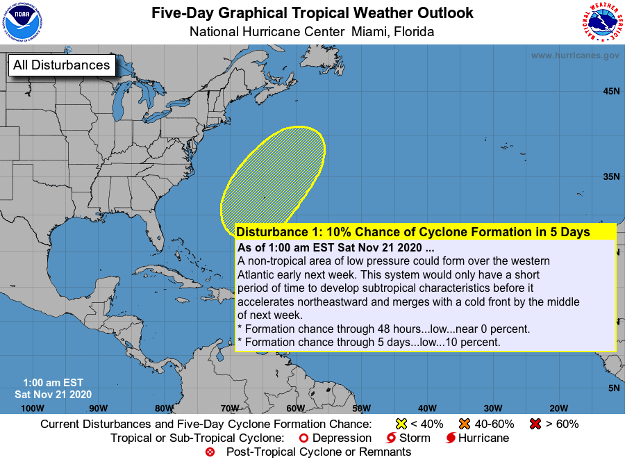
TROPICS: There is a small possibility that a non-tropical area of low pressure could form over the western Atlantic early next week. This system would have only a short time to develop subtropical characteristics before it accelerates northeastward and merges with a cold front by the middle of the week. Formation chance through the next 120 hours is only 10%. The rest of the Atlantic Basin is rather quiet. Only nine days remain in the Atlantic Hurricane Season for 2020, as it ends Nov. 30.
ON THIS DATE IN 1985: Hurricane Kate made landfall during the evening near Mexico Beach, Florida. Wind gusts to 100 mph were reported at Cape San Blas. It was the latest known hurricane to hit the U.S. so far north.
ON THIS DATE IN 1992: A powerful storm system traversing central Texas set off severe thunderstorms that spawned six tornadoes within 70 minutes in the Houston metropolitan area. At one time, there were three tornadoes on the ground at the same time in Harris County. The strongest tornado of this group (F4) tracked 20 miles through the eastern suburbs of Houston, destroying more than 200 homes and damaging more than 1,000. Beginning in the late evening and into the early morning of Nov. 22, 23 tornadoes struck Mississippi and Alabama. An F4 tornado killed 12 people on a 128-mile track through seven counties in Mississippi.
BEACH FORECAST CENTER: Get the latest weather and rip current forecasts for the beaches from Dauphin Island to Panama City Beach, Florida, on our Beach Forecast Center page. There, you can select the forecast of the region you are interested in.
For more weather news and information from James Spann, Scott Martin and other members of the James Spann team, visit AlabamaWx.


