James Spann: Dry, colder day for Alabama; rain returns over the weekend
James Spann forecasts cold air for Alabama into Friday from Alabama NewsCenter on Vimeo.
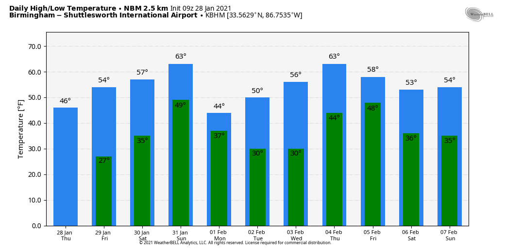
DRY THROUGH FRIDAY: Sunshine returns to Alabama in full force today; look for a high between 45 and 49 degrees this afternoon for most communities. The average high for Birmingham on Jan. 28 is 55. Tonight will be clear and cold. We project a low in the mid 20s early Friday; some of the colder spots could see low 20s. Then, during the day, the sky will be sunny with a high in the mid 50s.
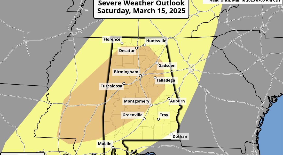
THE ALABAMA WEEKEND: The day Saturday will be dry with a high in the low to mid 60s. After morning sunshine, clouds move in by afternoon and rain arrives Saturday night. For now the air looks stable and there is no risk of severe thunderstorms, and probably little thunder. The rain will end Sunday morning; amounts of one-half inch or less are expected. Clouds linger through much of the day Sunday and temperatures will remain mild, with highs in the 60s.
NEXT WEEK: Colder, drier air arrives Monday as highs drop into the upper 40s. We stay rain-free Tuesday and Wednesday with highs in the 50s. Rain, and possibly a few thunderstorms, will return Thursday night and Friday; it’s too early to know if strong storms will be a possibility.
ON THIS DATE IN 2014: Light snow was forecast for north and central Alabama as a winter storm approached; heavier snow amounts were expected for the southern half of the state, where moisture was deeper. A “dusting” was forecast for places like Birmingham and Tuscaloosa. As it turned out, Birmingham would receive 2 inches of snow from the event. Light snow, but still more than a “dusting.” It turned out to be a “dusting of chaos.”
But the big forecast bust involved impact, which is all that matters. We expected no travel issues for the I-20 corridor. Horribly wrong. As the light snow fell on the morning of Jan. 28, it melted due to warm ground temperatures. But the air temperature was only 18 degrees, and the snow melt immediately turned to ice — a flash freeze, something we have no experience with here. Roads were coated with ice and turned into skating rinks. The 2 inches of snow had the impact of a major ice storm for travel, and as everyone left from work and school at the same time on ice-covered roads, there was gridlock. Some were stranded on roads for more than 10 hours. Many abandoned their vehicles and walked, looking for shelter. Nine deaths were attributed to accidents that occurred due to the icy road conditions.
We often wonder if we should be in the business of forecasting road conditions anyway; our training is all about what happens in the atmosphere, not ice accretion on roads.
For me, in terms of forecast busts, it ranks No. 2 on the list in a 42-year career. No. 1 was the 1982 ice storm, a catastrophic event when ice and snow came in almost eight hours ahead of forecast.
BEACH FORECAST: Click here to see the AlabamaWx Beach Forecast Center page.
WEATHER BRAINS: You can listen to our weekly 90-minute show anytime on your favorite podcast app. This is the show all about weather featuring many familiar voices, including the meteorologists at ABC 33/40.
CONNECT: You can find me on the major social networks:
For more weather news and information from James Spann and his team, visit AlabamaWx.