James Spann: Wet day for Alabama; colder air arrives Friday
James Spann forecasts a wet day for Alabama, with colder air on the way from Alabama NewsCenter on Vimeo.
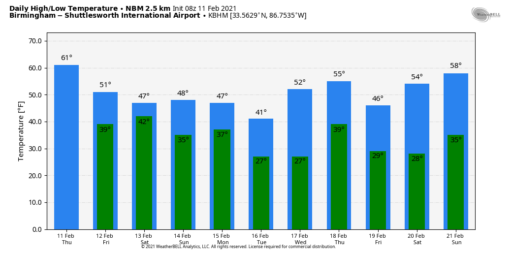
RADAR CHECK: Rain covers much of north and west Alabama this morning, with a few embedded thunderstorms. Occasional rain will continue today; the storms involved are noisy and are producing heavy rain, but should remain below severe limits. A cold front is draped over the northwest part of Alabama early this morning, and there is a big thermal contrast. North of the front Muscle Shoals reports 44 degrees, while Birmingham is at 61 just before daybreak. The front will creep slowly southward today; north Alabama will hold in the 40s, while the southern part of the state will stay in the 60s.
TO THE NORTH: An ice storm warning remains in effect for parts of Arkansas, west Tennessee and much of Kentucky as freezing rain continues to fall this morning. Travel is discouraged; scattered power outages are reported already.
FRIDAY AND THE WEEKEND: A decent part of the day Friday will be dry; the sky will be mostly cloudy with temperatures in the 40s over the northern half of the state. The next wave brings rain, mostly light, to the state Friday night into Saturday morning. A touch of freezing rain can’t be totally ruled out early Saturday across northwest Alabama, but for now it looks like temperatures there will be generally in the mid 30s as the rain falls. The rain will end from west to east Saturday afternoon; otherwise the day will be cloudy and cold with temperatures in the 30s over the Tennessee Valley, 40s for north and central Alabama, and 50s for the southern half of the state.
Sunday looks generally dry; the sky will be mostly cloudy with a high in the 40s for most places.
NEXT WEEK: Yet another wave in this complex pattern will bring lots of precipitation to Alabama late Monday and Monday night. The reliable European global model suggests thermal values will favor just rain for most of Alabama, with some potential for freezing rain over the northwest corner of the state. It is too early for a specific forecast at this point; once we get today’s rain out of here we can focus on this event. As discussed here often in the past week, shallow layers of cold air near the surface can be problematic for global models, certainly for an event five days out.
The precipitation will end early in the day Tuesday. Colder air will drop southward and the northern half of the state will likely hold in the 30s all day. Wednesday will be dry before rain returns Thursday.
ON THIS DATE IN 1983: A major snowstorm called the “Megalopolitan blockbuster snowstorm” affected the Mid-Atlantic and southern New England. Snowfall up to 25 inches fell at Allentown, Pennsylvania. Snowfall of 35 inches occurred in parts of the Blue Ridge Mountains of West Virginia at Glen Cary. Windsor Locks, Connecticut, recorded a record 19 inches in 12 hours. A ship sank off the Virginia/Maryland coast, killing 33.
BEACH FORECAST: Click here to see the AlabamaWx Beach Forecast Center page.
WEATHER BRAINS: You can listen to our weekly 90-minute show anytime on your favorite podcast app. This is the show all about weather featuring many familiar voices, including the meteorologists at ABC 33/40.
CONNECT: You can find me on all of the major social networks:
For more weather news and information from James Spann and his team, visit AlabamaWx.


