James Spann: Warming trend begins in Alabama over the weekend
RADAR CHECK: We have a few snow flurries over the northwest corner of Alabama today, where some spots received 5 inches of snow last night from a big Deep South winter storm. Otherwise, the sky is cloudy over the state with temperatures well below average for mid-February. We will maintain the chance of a few snow flurries tonight; otherwise the weather will be cloudy and cold, with lows mostly in the 20s.
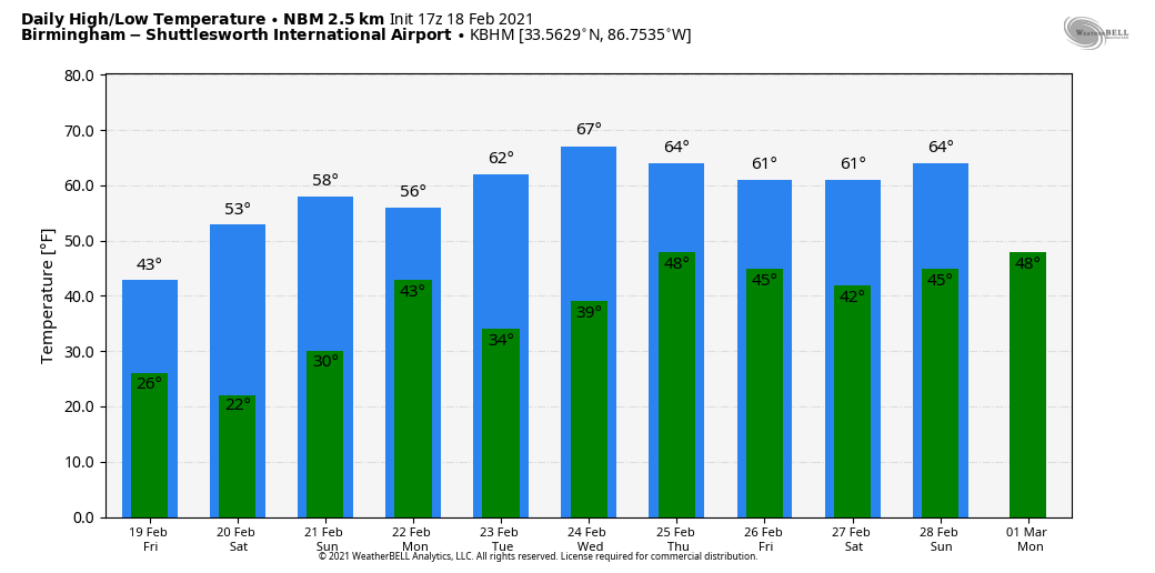
FRIDAY AND THE WEEKEND: Friday will be cold and dry; morning clouds will give way to afternoon sunshine for most places. The high will be in the 30s over the northern third of the state, 40s for central Alabama and 50s to the south. Saturday morning will be cold, with a low between 17 and 25 degrees, a clear sky and light wind. Then, a nice warming trend begins; we rise into the mid 50s Saturday and low 60s Sunday with a good supply of sunshine both days.
NEXT WEEK: A weak Pacific front will bring the chance of a few showers Monday morning, but moisture will be limited and rain amounts light and spotty. The high will be in the upper 50s Monday; then we rise into the 60s Tuesday and Wednesday with a good supply of sunshine both days. Showers return Thursday, and Friday looks dry and mild for now. There’s no sign of any new Arctic air shots for the rest of February.
ON THIS DATE IN 1992: A thunderstorm spawned an unusually strong F4 tornado for so far north this time of the year in southern Van Wert County in Ohio. The tornado touched down just west of U.S. Route 127 and traveled northeast for about 3 miles. One house was completely leveled and nine others sustained severe damage. Six people were injured.
ON THIS DATE IN 2009: A long-lived supercell thunderstorm moved from Sumter County east to Montgomery County. Damage along the path was the result of straight-line winds; localized areas received winds up to 70 mph. Minor to moderate damage was discovered in Sumter, Greene, Hale, Perry and Dallas counties. The damage was generally confined to shallow-rooted trees and weaker structures. The storm also produced a swath of hail that covered the ground in many places and was golf ball to baseball size.
BEACH FORECAST: Click here to see the AlabamaWx Beach Forecast Center page.
WEATHER BRAINS: You can listen to our weekly 90-minute show anytime on your favorite podcast app. This is the show all about weather featuring many familiar voices, including the meteorologists at ABC 33/40.
CONNECT: You can find me on the major social networks:
For more weather news and information from James Spann and his team, visit AlabamaWx.


