James Spann: Another spring-like day ahead for Alabama
James Spann has a mild midweek forecast for Alabama from Alabama NewsCenter on Vimeo.
ANOTHER BIG WARM-UP: Temperatures will rise quickly across Alabama today. Most communities will reach the low 70s this afternoon with a strong February sun. The average high for Birmingham on Feb. 24 is 61. Clouds will increase late tonight and a few isolated showers or sprinkles are possible Thursday ahead of a cold front, but most of the day will be dry with a high between 67 and 70 degrees.
Rain becomes likely statewide late Thursday night and Friday; amounts of around 1 inch are likely, with heavier totals over the northern third of the state. A few rumbles of thunder are possible, but severe storms are not expected. Friday will be cooler over the northern third of the state with a high in the 50s.
THE ALABAMA WEEKEND: The front will drift northward and will be near the Tennessee border Saturday. The weekend will be very mild for Alabama, with highs in the 70s, and with a moist air mass in place we will need to mention a chance of showers both days. But for most of the state the weekend won’t be a washout, with potential even for a few intervals of sunshine. The most widespread rain will be over the Tennessee Valley and points north.
NEXT WEEK: The position of the surface front will determine the chance of rain each day, and global models are not in good agreement. Showers remain likely Monday, but there is a chance drier air could creep into north Alabama Tuesday and Wednesday with cooler temperatures. But, again, the forecast for the week is a low-confidence one.
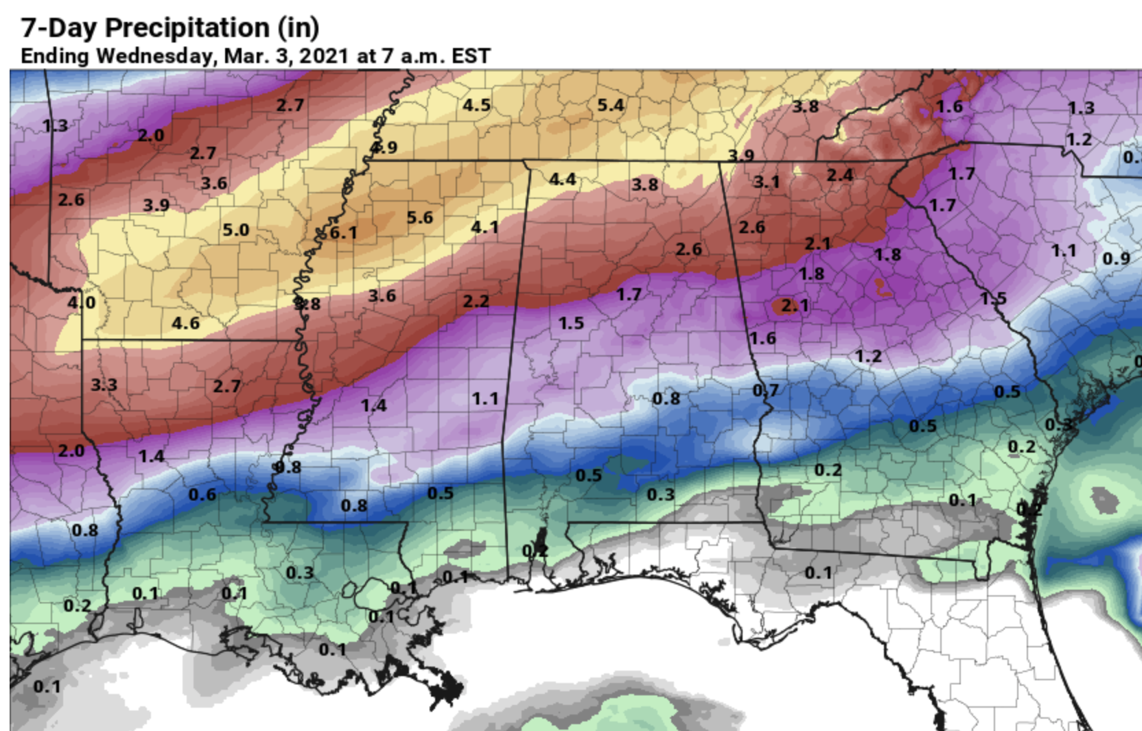
Rain totals over the next seven days will vary a good bit across Alabama with a tight gradient; Muscle Shoals could see more than 4 inches of rain, while Dothan will be mostly dry.
ON THIS DATE IN 1961: An F2 tornado moved through Russell County in east Alabama. Although it moved mostly through rural areas, the tornado left several homes obliterated, while others were heavily damaged and many trees were blown down or broken off. Four people were injured.
ON THIS DATE IN 1969: The famous “100-Hour Storm” began in Boston. Snow fell much of the time between early Feb. 25 through noon Feb. 28. The 26.3 inches at Logan Airport is the second-greatest snowstorm in Boston’s history. 77 inches fell at Pinkham Notch Base Station in New Hampshire, bringing its February total to 130 inches; the snow cover on Feb. 27 was 164 inches. Mt. Washington, New Hampshire, received 172.8 inches of snow in the month.
BEACH FORECAST: Click here to see the AlabamaWx Beach Forecast Center page.
WEATHER BRAINS: You can listen to our weekly 90-minute show any time on your favorite podcast app. This is the show all about weather featuring many familiar voices, including the meteorologists at ABC 33/40.
CONNECT: You can find me on the major social networks:
For more weather news and information from James Spann and his team, visit AlabamaWx.


