James Spann: Sunny day for Alabama; storms return late Wednesday night
James Spann forecasts another beautiful day for Alabama before storms return from Alabama NewsCenter on Vimeo.
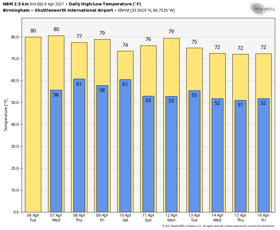
ANOTHER FINE SPRING DAY AHEAD: We won’t see much change in Alabama’s weather today. Dry air means a mostly sunny day with a high between 77 and 82 degrees this afternoon. The sky will remain mostly fair tonight, and the daytime Wednesday will stay dry with a gradual increase in clouds by afternoon. The high will be in the upper 70s and low 80s again.
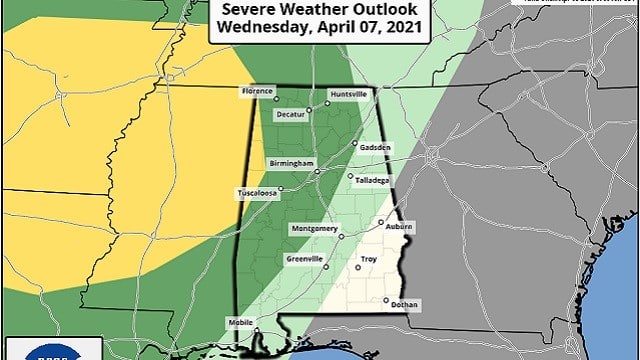
A band of thunderstorms will push into the state late Wednesday night into the early morning Thursday. The Storm Prediction Center has defined a slight risk (level 2 of 5) for a few counties near the Mississippi border and a marginal risk (level 1 of 5) as far east as Scottsboro, Clanton and Jackson.
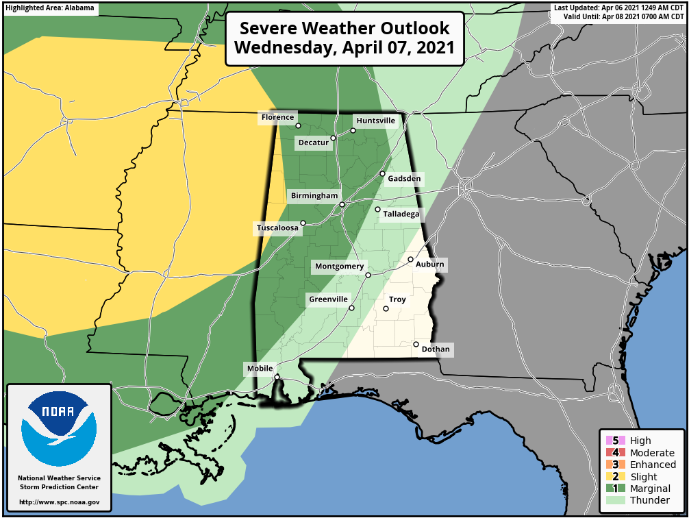
The main window for the storms for the northern half of the state will come from about 10 Wednesday night through 10 a.m. Thursday. Heavier storms could produce strong, gusty winds and some small hail. A brief, isolated tornado is possible, but not likely. Storms should slowly weaken as they push into east Alabama Thursday morning.
By Thursday afternoon, the best chance of showers and storms will be over the southern counties of the state as a slot of drier air works into north Alabama. Thursday’s high will be in the mid 70s.
FRIDAY AND THE WEEKEND: Another round of rain and storms will move into the state Thursday night, and the weather will be unsettled Friday and Saturday with occasional showers and thunderstorms likely. There will be breaks in the rain, and for now the chance of organized severe weather looks low. But a few strong storms can’t be ruled out. Rain amounts between Wednesday night and Saturday will be 2-3 inches for most of the state, and highs will remain in the 70s Friday and Saturday. Dry air moves into the state Sunday with a mostly sunny sky returning. Sunday’s high will be in the mid to upper 70s.
NEXT WEEK: For now the weather looks dry Monday and Tuesday. Showers and storms will return at some point over the latter half of the week, but models are not in good agreement as you might expect that far out in this active pattern.
ON THIS DATE IN 1973: A major spring snowstorm dumped 11.6 inches of snow across Denver, Colorado. Most of the heavy, wet snow of 10.1 inches fell on April 7, when temperatures remained in the 20s. The low temperature of 5 degrees on April 8 was a new record low for the date and the lowest for so late in the season.
ON THIS DATE IN 2016: Nine tornadoes touched down in southeast Alabama, including an EF-2 in eastern Bullock County. Three EF-0 tornadoes touched down in Montgomery County.
BEACH FORECAST: Click here to see the AlabamaWx Beach Forecast Center page.
WEATHER BRAINS: You can listen to our weekly 90-minute show any time on your favorite podcast app. This is the show all about weather featuring many familiar voices, including the meteorologists at ABC 33/40.
CONNECT: You can find me on the major social networks:
For more weather news and information from James Spann and his team, visit AlabamaWx.


