James Spann: Occasional showers, storms for Alabama through Wednesday
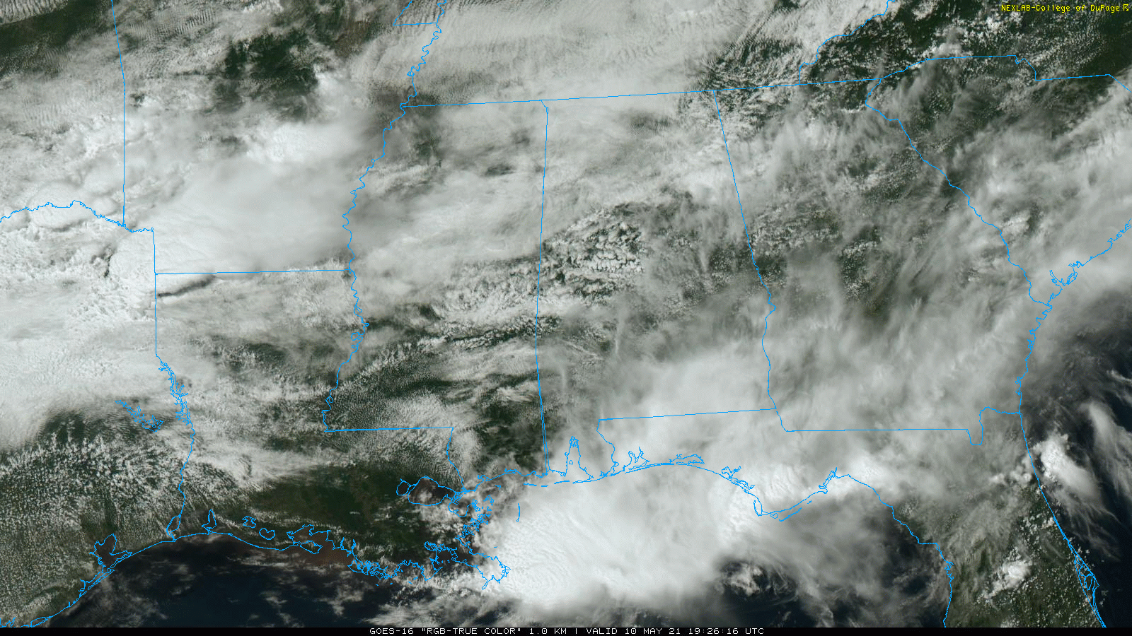
RADAR CHECK: We have a few small, isolated showers across central Alabama this afternoon, but most of north and central Alabama is rain-free with a mostly cloudy sky. A few patches of blue sky have shown up, and temperatures are mostly in the low to mid 70s along and south of I-20. But temperatures are only in the 60s over the northern third of the state, north of a stalled surface front.
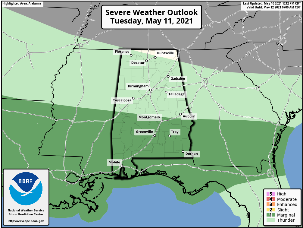
Rain continues to fall over southeast Alabama this afternoon, but there is little thunder there, and the Storm Prediction Center has removed the marginal risk of severe weather for south Alabama.
TUESDAY/WEDNESDAY: The stalled surface front will meander across central Alabama. Several rounds of showers and storms are likely Tuesday and Tuesday night, and the SPC maintains a marginal risk of severe thunderstorms for roughly the southern half of the state. A few storms over south Alabama could produce small hail and strong, gusty winds.
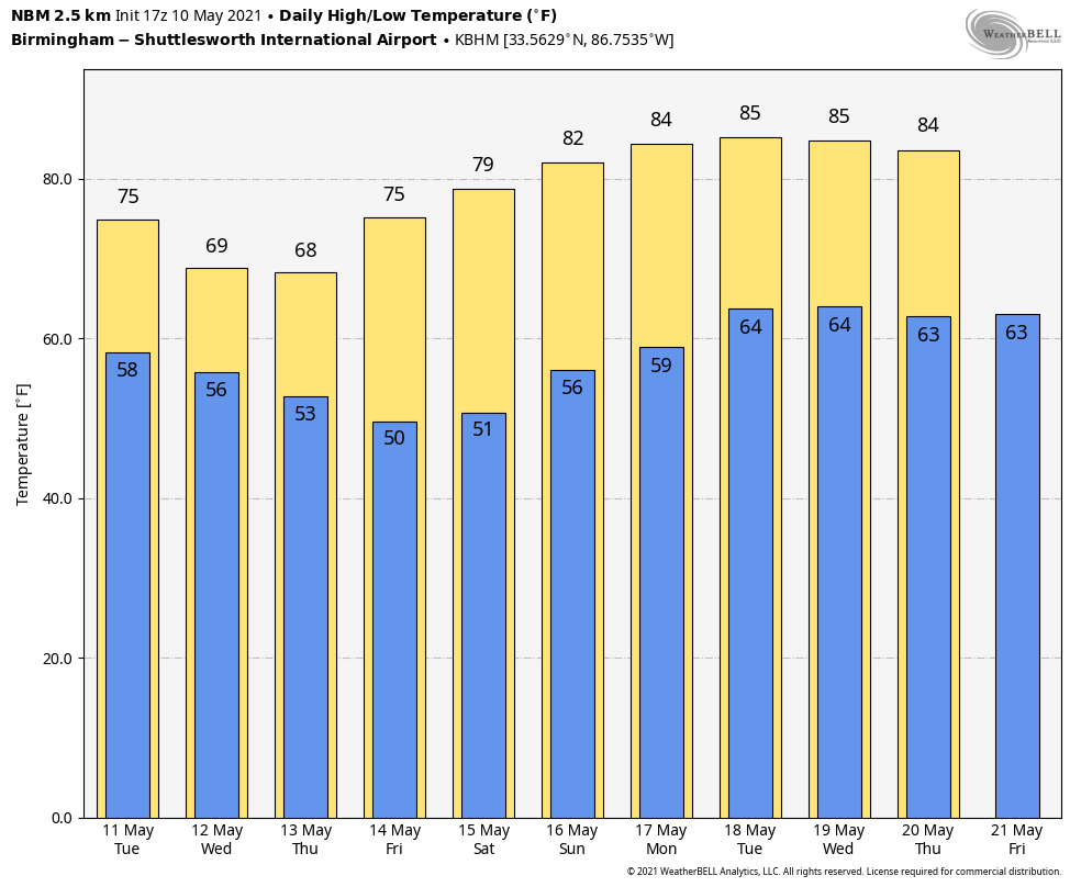
The high Tuesday will be between 70 and 75 degrees for most of the state. On Wednesday the front gets a southward push, and the high will be only in the 65- to 70-degree range for the northern half of the state, about 15 degrees below average for mid-May. A few scattered showers are possible Wednesday and Wednesday night; the most widespread rain will likely come over the southern counties of the state, south of the surface front.
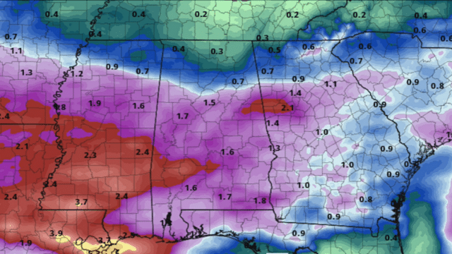
Additional rain amounts between now and Wednesday night will be 1-2 inches for much of the state.
THURSDAY THROUGH THE WEEKEND: Dry air will move in during the day Thursday; morning clouds will give way to a partly sunny afternoon. Temperatures remain unseasonably cool for May, with highs in the mid to upper 60s. Look for sunshine in full supply Friday and Saturday with a warming trend. The high will be in the mid 70s Friday and close to 80 by Saturday afternoon. Sunday is expected to be dry and warm, with a partly sunny sky and a high in the low 80s.
NEXT WEEK: A developing upper ridge over the region will keep much of the week dry and warm, with highs in the mid 80s.
TROPICS: Tropical Storm Andres remains weak this afternoon in the eastern Pacific with winds of 40 mph. It is expected to dissipate over the open Pacific in the next 48 hours well west of the Mexican coast. The Atlantic basin hurricane season opens June 1.
ON THIS DATE IN 2006: An EF1 tornado moved through Marengo County in west Alabama, producing damage in Linden. Flash flooding also affected Linden. Several roadways were temporarily impassable due to high water and a few buildings suffered water damage.
ON THIS DATE IN 2010: Oklahoma experienced its largest tornado outbreak since May 3, 1999. Fifty-five twisters tore through the state, including two rated EF4. The EF4 storms took three lives and injured 81 people. Both EF4 tornadoes struck Norman, Oklahoma, home of the Storm Prediction Center and the National Severe Storms Laboratory. Fourteen additional tornadoes hit Oklahoma during May 11-13. The May 10 disaster racked up insured property losses of $2 billion.
BEACH FORECAST: Click here to see the AlabamaWx Beach Forecast Center page.
WEATHER BRAINS: You can listen to our weekly 90-minute show any time on your favorite podcast app. This is the show all about weather featuring many familiar voices, including the meteorologists at ABC 33/40.
CONNECT: You can find me on the major social networks:
For more weather news and information from James Spann and his team, visit AlabamaWx.


