James Spann: Alabama has air you can wear; scattered showers, storms remain possible
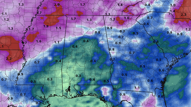
RADAR CHECK: So far showers and storms are scarce this afternoon over the northern half of Alabama. Most of the action on radar is over the southern counties of the state, mainly south of U.S. 80. However, a very moist air mass remains in place, and we expect a number of showers and storms to form over the next few hours statewide. Otherwise, we have a mix of sun and clouds with temperatures mostly in the mid 80s.

FRIDAY THROUGH THE WEEKEND: The sky will be occasionally cloudy Friday with scattered to numerous showers and thunderstorms; the chance of any one spot getting wet is 60-70%. Then, showers should become fewer in number over the weekend as the air becomes a little drier. We expect a partly sunny sky Saturday and Sunday with a few scattered storms during the afternoon and evening hours. The chance of rain for any one community over the weekend drops to 20-30% both days. Afternoon highs will generally remain in the mid 80s.
NEXT WEEK: A trough will bring a higher coverage of showers and thunderstorms Monday; then the rest of the week should feature pretty routine summer weather — partly sunny days with the usual chance of scattered, mostly afternoon and evening showers and thunderstorms daily. Highs will be mostly in the upper 80s, a bit below average for mid-July.
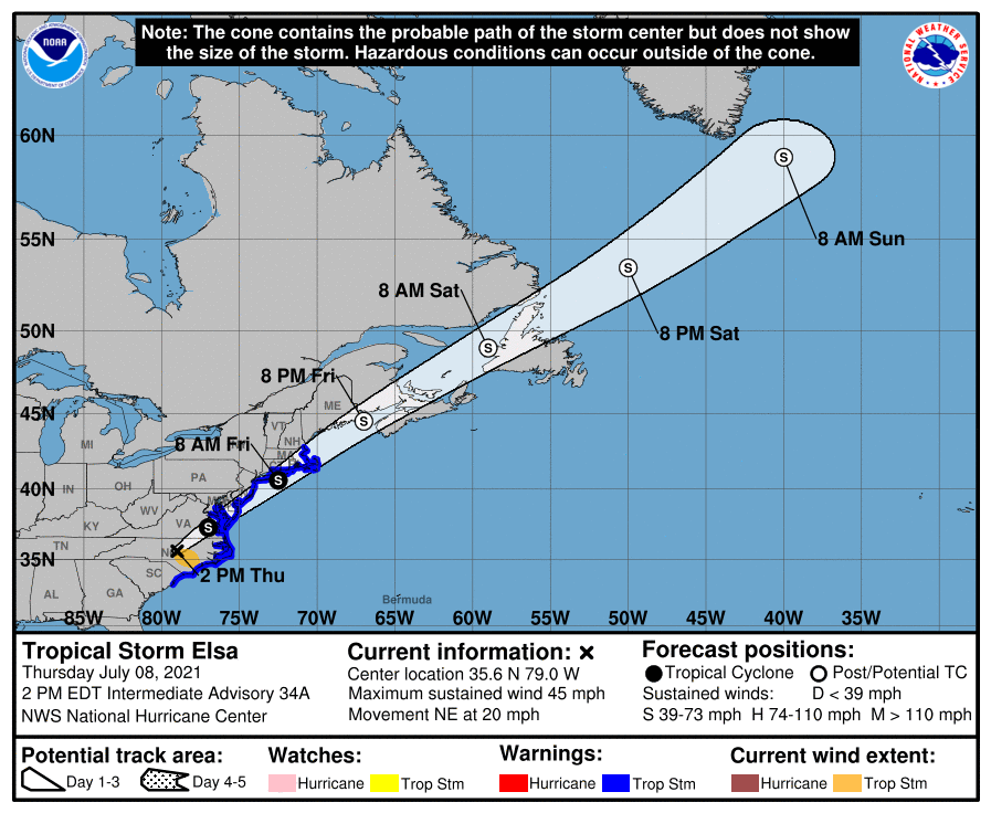
ELSA MOVING NORTHEAST: Tropical storm Elsa at mid-afternoon is about 25 miles southwest of Raleigh, North Carolina, and continues to move northeast at 20 mph. It will bring lots of rain and the risk of isolated tornadoes to the upper Atlantic Coast through Friday night.
 Elsewhere, a broad area of low pressure nearly stationary over south Texas is continuing to produce a large area of disorganized showers and thunderstorms over the northwestern Gulf of Mexico. Although development of this system is not anticipated since it is expected to remain over land, heavy rainfall and flash flooding will be possible along the Texas Gulf coast over the next few days. The rest of the Atlantic basin is very quiet, and additional tropical storm formation is not expected through early next week.
ON THIS DATE IN 2003: What may be the world’s highest dew point temperature was recorded at Dhahran, Saudi Arabia, in the Persian Gulf. A dew point of 95 degrees was recorded at 3 p.m. while the air temperature was 108 degrees. The apparent temperature at that time would have been 172 degrees.
BEACH FORECAST: Click here to see the AlabamaWx Beach Forecast Center page.
WEATHER BRAINS: You can listen to our weekly 90-minute show any time on your favorite podcast app. This is the show all about weather featuring many familiar voices, including the meteorologists at ABC 33/40.
CONNECT: You can find me on the major social networks:
For more weather news and information from James Spann and his team, visit AlabamaWx.


