Scott Martin: Very hot day for Alabama, with a few isolated showers, storms possible
 TODAY’S WEATHER: Today will be very hot and dry with plenty of sunshine. A few isolated showers or storms may be possible for northern Alabama. Highs will be in the mid to upper 90s.
THIS WEEKEND: On Saturday, moisture will start to move back into the mid-levels as a cold front approaches from the north. Skies will be mostly sunny, but we’ll have a chance for a few isolated to scattered showers and storms. Highs will be in the mid to upper 90s. Rain chances start to rise Sunday as the front starts to move in and stalls out over northern Alabama. We can expect a few scattered showers and storms during the afternoon, with highs reaching the upper 80s to the upper 90s.
NEXT WEEK: Showers and thunderstorms become more likely Monday as the front continues to hang out over the northern parts of the state. Skies will be mostly cloudy and highs will be in the 80s. The front finally starts to move southward Tuesday and will push much of the shower and thunderstorm activity over the southern half of the state. However, we still can’t rule out a few scattered showers and storms over the northern half. Highs will be in the 80s.
Wednesday looks like we return to more of the typical summertime weather we expect to see in Alabama — mostly sunny with a slight chance of a few isolated to scattered afternoon showers and storms. Highs will be in the mid to upper 80s. Thursday and Friday will be pretty similar. Highs will be in the mid to upper 80s on Thursday, into the upper 80s to the lower 90s on Friday.
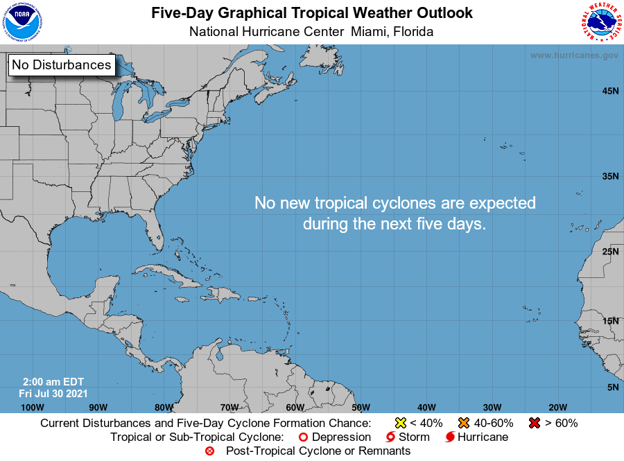
TROPICS: All is quiet across the Atlantic basin, and tropical cyclone formation is not expected within the next five days.
For more weather news and information from James Spann, Scott Martin and other members of the James Spann team, visit AlabamaWx.


