James Spann: Unsettled weather continues in Alabama through Saturday
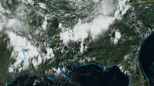
RADAR CHECK: Large areas of rain and a few thunderstorms are seen across north and central Alabama this afternoon. Stronger storms are producing very heavy rain, gusty winds and lots of lightning. A few Flash Flood Warnings have been required today, and isolated flooding will remain possible through the evening. Where rain is falling temperatures are in the 70s, but we are seeing mostly low 90s over south Alabama, where showers are much more scattered.

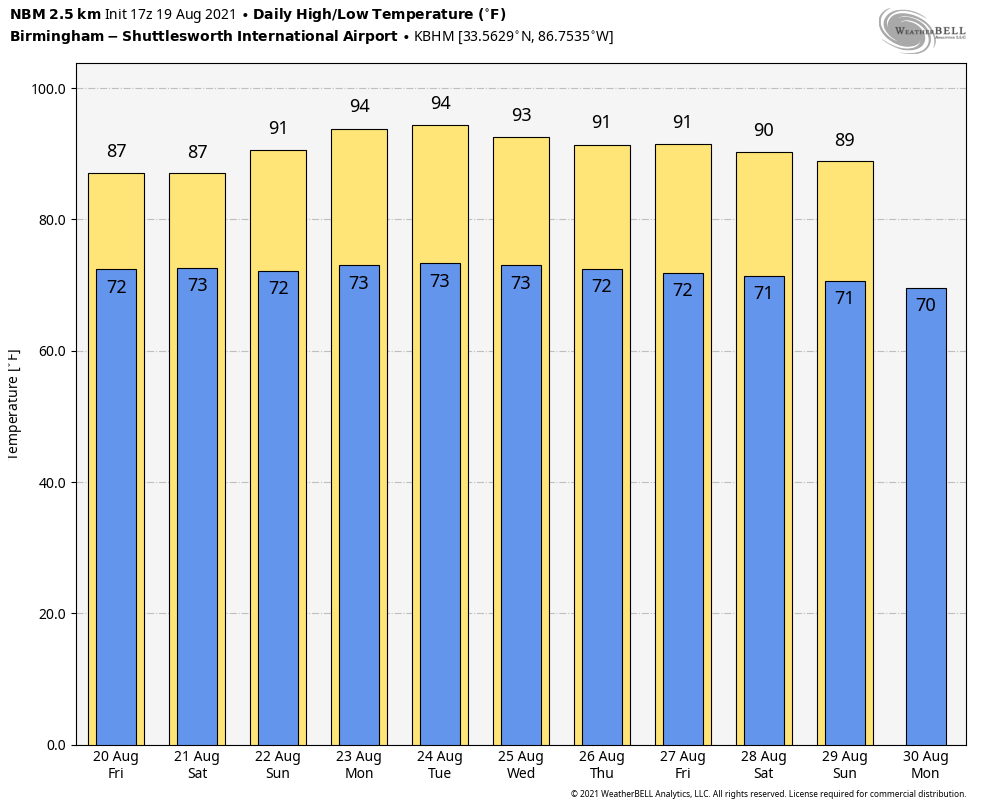
The weather won’t change much Friday and Saturday; expect more clouds than sun with scattered to numerous showers and thunderstorms both days. Like today, rain could be heavy in spots and temperatures will remain below average highs, mostly between 84 and 88 degrees.
SUNDAY AND NEXT WEEK: An upper ridge begins to build over the region, and the weather trends hotter and drier Sunday. With a partly to mostly sunny sky, the high will be around 90 degrees with just a few isolated afternoon showers or thunderstorms. Highs will climb into the low to mid 90s Monday and Tuesday with a good supply of sunshine both days; showers should be scarce. Then, as the ridge weakens, scattered showers and storms will become more numerous over the latter half of the week with highs back around 90 degrees.
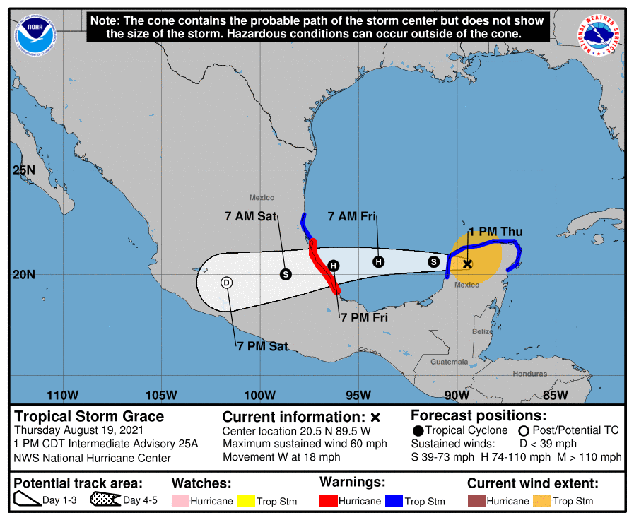
TROPICS: Grace has weakened to a tropical storm; it is inland over the Yucatan peninsula of Mexico. It will emerge into the Bay of Campeche tonight, and the next landfall comes along the coast of Mexico, far south of Brownsville, Texas, Friday night as a Category 1 hurricane. This track is far south of the U.S., but Grace will stir the pot and bring the risk of rip currents to the central Gulf Coast tonight and Friday.
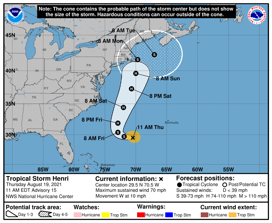
Over in the Atlantic, Tropical Storm Henri is expected to become a hurricane in about 24 hours between Bermuda and the U.S. East Coast. The latest National Hurricane Center forecast has the system very close to Cape Cod late Sunday night and Monday morning as an upper-end tropical storm. It should be noted that as Henri gains latitude and moves near New England, the wind field is expected to expand and impacts will be possible far from the center.
The rest of the Atlantic basin is quiet.
ON THIS DATE IN 1991: Hurricane Bob made landfall in Rhode Island as a Category 2 hurricane. Eighteen fatalities were reported in association with Bob; the loss of life and most of the damage occurred as a result of high winds and rough seas. There were six confirmed tornadoes during its passage. Bob is the last hurricane to hit the New England states directly as a hurricane. It was the only hurricane to make landfall in the contiguous United States during the 1991 season.
BEACH FORECAST: Click here to see the AlabamaWx Beach Forecast Center page.
WEATHER BRAINS: You can listen to our weekly 90-minute show any time on your favorite podcast app. This is the show all about weather featuring many familiar voices, including the meteorologists at ABC 33/40.
CONNECT: You can find me on the major social networks:
For more weather news and information from James Spann and his team, visit AlabamaWx.


