James Spann: Ida to affect Alabama weather early next week
James Spann forecasts routine summer weather for Alabama until Ida lands from Alabama NewsCenter on Vimeo.
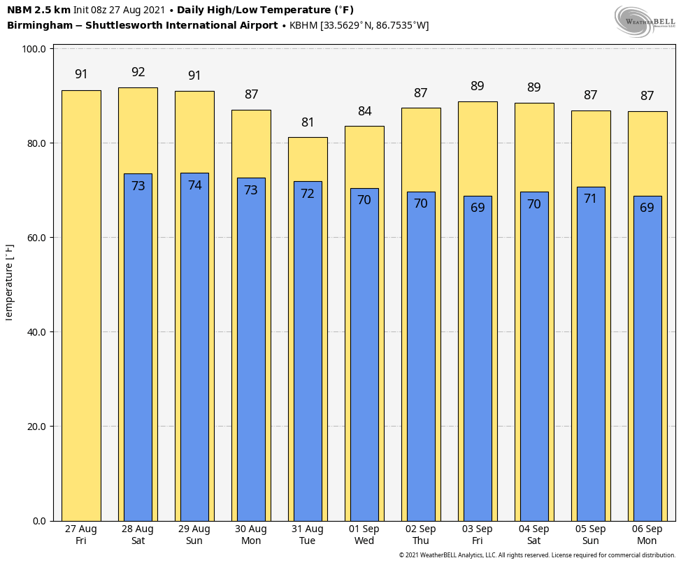
ROUTINE WEATHER THROUGH THE WEEKEND: We expect some pretty routine summer weather for Alabama through Sunday with partly sunny days, fair nights, and scattered showers and storms during the afternoon and evening hours. Odds of any one spot getting wet daily is 25-35%, and highs will be mostly between 87 and 90 degrees. Clouds will increase Sunday night as Hurricane Ida moves into southeast Louisiana.
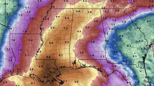
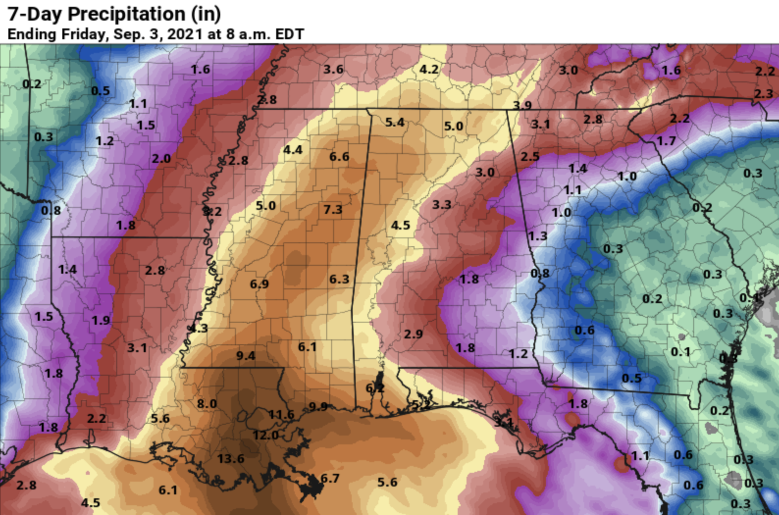
NEXT WEEK: The National Hurricane Center is forecasting the circulation of Ida to move through Mississippi Monday and Tuesday, winding up near Muscle Shoals Tuesday night. This puts Alabama on the wet, unsettled east side of the system. Rain over west and southwest Alabama Monday will spread northward, and much of the state will have widespread rain Monday night and Tuesday. The rain could be heavy at times and flooding is possible. Amounts will be 3-5 inches over the western half of the state, with amounts of 1-3 inches for the eastern counties.
In addition to the flooding risk, a few isolated tornadoes will be possible — initially over west and southwest Alabama Monday, and statewide Monday night and Tuesday. But uncertainty still remains high regarding the overall evolution of Ida as it moves inland and how buoyant the environment over Alabama will be, so it is a little too early to know the magnitude of the tornado threat. Typically tornadoes associated with tropical systems tend to be short-lived and can touch down with little warning.
Rain will taper off by Wednesday, and drier air arrives Thursday and Friday with lots of sunshine and lower humidity levels. Some north Alabama communities could reach the 50s Thursday and Friday morning.
IDA: Tropical Storm Ida this morning is about 50 miles north of Grand Cayman with winds of 45 mph. It is forecast to become a hurricane in the southern Gulf of Mexico Saturday; landfall is forecast on the southeast Louisiana coast Sunday afternoon at major Category 3 strength.
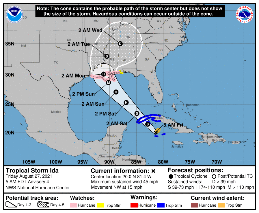
There is an increasing risk of dangerous hurricane-force winds beginning Sunday along the portions of the coasts of Louisiana and Mississippi, including metropolitan New Orleans. A Hurricane Watch is in effect from Cameron, Louisiana, to the Mississippi/Alabama border, including Lake Pontchartrain, Lake Maurepas and metropolitan New Orleans. A Tropical Storm Watch is in effect for the Alabama Gulf Coast and Mobile Bay.
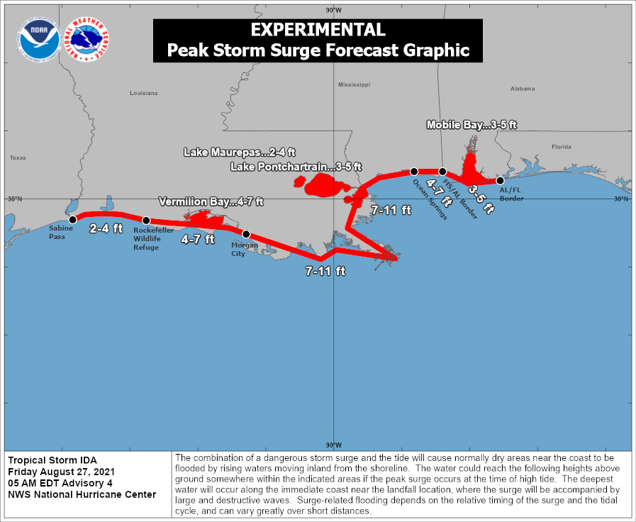
There is an increasing risk of life-threatening storm surge inundation along the coasts of Louisiana, Mississippi and Alabama, where a Storm Surge Watch is in effect. Interests in these areas should follow any advice given by local officials.
A Storm Surge Watch is in effect for Sabine Pass to the Alabama/Florida border and for Vermilion Bay, Lake Borgne, Lake Pontchartrain, Lake Maurepas and
Mobile Bay.
A storm surge of 7-11 feet is forecast in the Hurricane Watch area (southeast Louisiana and Mississippi). In Alabama, a storm surge of 3-5 feet is forecast along the coast and around Mobile Bay.
Ida is also expected to produce heavy rains across the central Gulf Coast from southeast Louisiana to coastal Mississippi, Alabama and the Lower Mississippi Valley starting Sunday into Monday, resulting in considerable flash, urban, small stream and riverine flooding. Rain amounts could exceed 1 foot across southeast Louisiana and far south Mississippi. Mobile and Baldwin counties and the western Florida Panhandle could see 5-7 inches.
A few isolated waterspouts and tornadoes are possible along the Gulf Coast east of the landfall point Sunday night and Monday. Dangerous rip currents are likely along the entire central Gulf Coast, including the entire Florida Panhandle coast, Saturday through Monday.
While the main impact of Ida will be west of Destin and Panama City Beach, there will be periods of rain there Sunday through Tuesday along with the rip current danger.
The weather will begin to improve along the Gulf Coast late Tuesday and Tuesday night as Ida moves away from the region.
ELSEWHERE IN THE TROPICS: Two systems in the Atlantic have some potential to become a tropical depression or storm over the next five days, but both will be moving away from the U.S. and basically are no threat to land.
ON THIS DATE IN 2005: Hurricane Katrina reached Category 3 intensity in the Gulf of Mexico about 335 miles south-southeast of the mouth of the Mississippi River with maximum sustained winds of 115 mph.
BEACH FORECAST: Click here to see the AlabamaWx Beach Forecast Center page.
WEATHER BRAINS: You can listen to our weekly 90-minute show any time on your favorite podcast app. This is the show all about weather featuring many familiar voices, including the meteorologists at ABC 33/40.
CONNECT: You can find me on the major social networks:
For more weather news and information from James Spann and his team, visit AlabamaWx.


