Scott Martin: A few storms for Alabama today; severe storms this weekend
FOGGY: We have a Dense Fog Advisory in effect for all of central Alabama, expiring at 9 a.m.
TODAY: After the fog dissipates, we’ll have mostly cloudy skies with a few showers possible through the morning; then showers and a few thunderstorms will become possible this afternoon and into the evening. Severe weather is not expected today, but a strong storm with gusty winds may be possible as a warm front moves northward through the state. Highs will be in the lower 70s to the lower 80s.
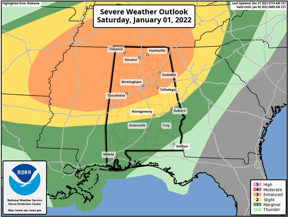
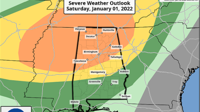
SEVERE THREAT FOR SATURDAY, EARLY SUNDAY: Strong to severe storms will be possible starting during the early afternoon Saturday as a strong cold front approaches from the west. The storms, along with the severe threat, will slowly progress across the state through the evening, late-night and pre-dawn hours. The threat should come to an end around mid-morning Sunday.
A level 3 enhanced risk of severe storms has been issued for the northern half of the state, mainly along and north of a line from Cuba to Jemison to Fruithurst. A level 2 slight risk is up south of that, down a line from Dixon’s Mill to just south of Montgomery to Auburn. A level 1 marginal risk is up for the rest of southern Alabama, except for the extreme southeastern corner. Tornadoes, damaging winds up to 70 mph and hail up to quarter-size in diameter will be possible with any severe storm that forms.
We could have some discrete cells form out ahead of the cold front and those could potentially start rotating, but the main action will occur within a squall line that will move through the state along with the cold front. That is where we could see the greater risk of damaging winds.
After the threat ends Sunday morning much colder air will move in, and with some wrap-around moisture on the back side of the low mixing with that colder air, we could see a few flurries over northern and northeastern Alabama. No accumulations are expected. Saturday’s highs will be in the mid-70s to the lower 80s. Sunday’s highs will occur very early in the morning, ranging from the upper 40s to the lower 70s, but those will drop throughout the day and will end up in the lower 20s to the lower 30s by sunrise Monday morning.
NEXT WEEK: Skies will be sunny Monday with high pressure in control of our weather, but it will be chilly. Highs will be only in the lower 40s to the lower 50s. Tuesday will be similar, but highs will be a little warmer, reaching the 50s.
Some moisture will try to sneak into the state on Wednesday, so we may have some clouds at times, and a couple of showers will be possible late Wednesday evening as another cold front begins to move through. Highs will be in the mid-50s to the mid-60s. Showers will remain possible throughout the morning and into the early afternoon Thursday, but those will move out before sunset. Highs will be in the mid-50s to the upper 60s. A reinforcing shot of colder air moves in on Friday, but we’ll have plenty of sunshine, with highs in the lower 40s to the mid-50s.
For more weather news and information from James Spann, Scott Martin and other members of the James Spann team, visit AlabamaWx.


