James Spann: Cold day for Alabama with gradual clearing
James Spann forecasts a cold, dry MLK Day for Alabama from Alabama NewsCenter on Vimeo.
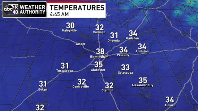
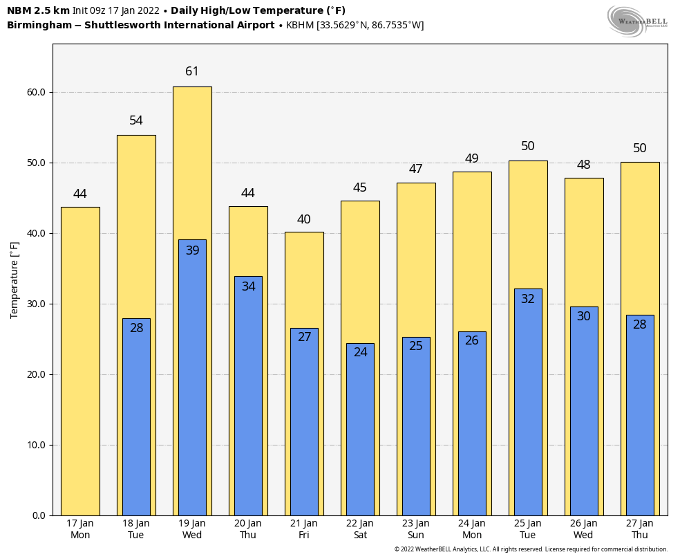
COLD MONDAY: In the wake of the system that brought lots of rain and snow to Alabama over the weekend, a cold air mass lingers this morning. Temperatures are mostly in the 30s, and a few spots over north Alabama are below freezing. We expect clouds this morning to give way to a partly sunny sky this afternoon; the high will be in the mid 40s. The average high for Birmingham on Jan. 17 is 54.
Tuesday will be sunny; after a morning low in the 20s, temperatures reach the mid 50s by afternoon.
REST OF THE WEEK: Clouds will increase Wednesday ahead of a cold front. Rain will push into the northwest part of the state by mid to late afternoon and is likely statewide Wednesday night. There could be a rumble of thunder in spots; the Storm Prediction Center has defined a marginal risk (level 1 out of 5) of severe thunderstorms for parts of southeast Texas, Louisiana and Mississippi, but severe storms are not expected in Alabama.
Rain ends early Thursday and another shot of cold air rolls into the state. Parts of north Alabama could hold in the 30s all day, and while a few snow flurries are possible over some northern counties early Thursday, no impact is expected. Friday will be cold and dry with a mix of sun and clouds; the high will be in the 40s.
THE ALABAMA WEEKEND: Global models from time to time have given signals of a potential surface low in the northern Gulf of Mexico Saturday, with a chance of rain or snow for Alabama. There is a great amount of inconsistency in model output, but the idea is plausible in this pattern, and there is some support from the ensembles. For now I will just keep it very broad and forecast a mostly cloudy day Saturday with a chance of some rain or snow; there won’t be much clarity for a few more days. If you have something planned outdoors Saturday, it could very well turn out to be a dry day; it’s just too early to call.
If a Gulf low forms, it will be gone by Sunday, and the day should be dry. Highs over the weekend should be mostly in the 40s.
NEXT WEEK: For now a decent part of the week looks dry with below-average temperatures; highs most days will be in the 40s and low 40s, with lows in the 20s and low 30s.
 ON THIS DATE IN 1994: At 4:31 a.m. PST, a magnitude 6.7 earthquake centered in Northridge struck southern California. Known as the Northridge Earthquake, it caused at least 57 fatalities (a subsequent study put the death toll at 72, including heart attacks) and injured thousands.
ON THIS DATE IN 1999: A total of 22 tornadoes touched down across parts of Arkansas, Mississippi and Tennessee. The most violent was an F4 tornado that tracked across southern Jackson, Tennessee, damaging more than 200 homes and 55 buses. The storm killed six people and injured 106.
BEACH FORECAST: Click here to see the AlabamaWx Beach Forecast Center page.
WEATHER BRAINS: You can listen to our weekly 90-minute show any time on your favorite podcast app. This is the show all about weather featuring many familiar voices, including the meteorologists at ABC 33/40.
CONNECT: You can find me on the major social networks:
For more weather news and information from James Spann and his team, visit AlabamaWx.


