James Spann: Some rain for southern half of Alabama this morning
James Spann forecasts some rain for south Alabama, dry in the north from Alabama NewsCenter on Vimeo.
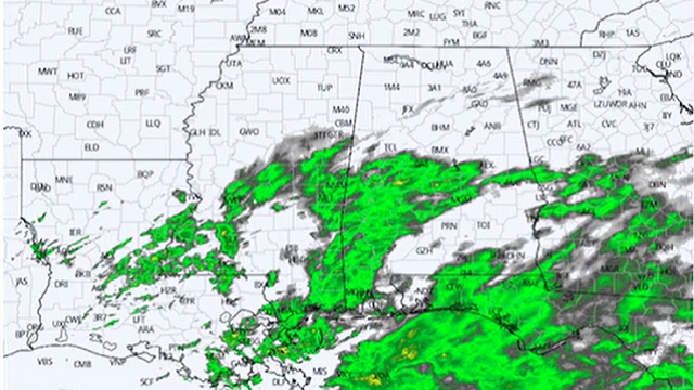
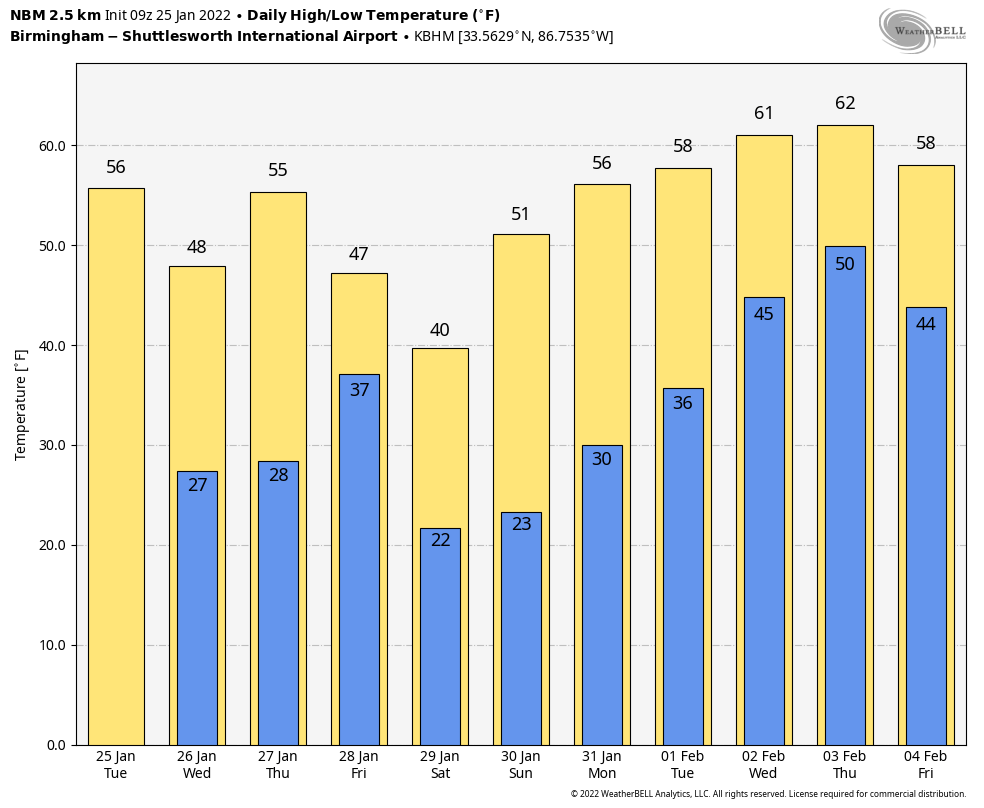
RADAR CHECK: A weather disturbance is bringing some patchy, light rain to the southern half of Alabama this morning. Rain is seen as far north as Nation, Clanton and Rockford. This rain will move out of the state later this morning; otherwise, today will be mostly cloudy with a high between 50 and 54 degrees. The sky will begin to clear over the northwest counties of the state this afternoon, and tonight will be clear and colder, with a low in the 20s.
REST OF THE WEEK: Wednesday and Thursday will feature a good supply of sunshine; the high will be in the mid to upper 40s Wednesday, followed by mid 50s Thursday. An upper trough and cold front will pass through Friday with some clouds, but for now measurable rain is not expected for most of the state with a dry air mass in place. The high Friday afternoon will be close to 50 degrees.
THE ALABAMA WEEKEND: The weather will be sharply colder Saturday; after starting the day between 20 and 25 degrees, the high will be somewhere between 38 and 44 degrees with a sunny sky. Look for another sunny day Sunday with a high in the 50s.
NEXT WEEK: A pattern change will bring warmer air into the state next week; highs will exceed 60 on most days. A cold front will bring a chance of showers by either Wednesday or Thursday.
ONE YEAR AGO TODAY: An EF-3 tornado moved through Fultondale, just north of downtown Birmingham, killing one person and injuring about 30 more. The parent storm was first tracked from near Interstate 55 in central Mississippi. As the storm moved across Mississippi and into west Alabama, it exhibited episodes of rotation, but none was strong enough to produce a tornado. As the storm entered Jefferson County, its structure became organized. A rotational signature quickly matured and a Tornado Warning was issued at 10:34 p.m. About 10 minutes later, the tornado started to produce damage.
The tornado began along Chapel Hills Parkway, where minor shingle damage occurred. It tracked northeastward across Ellard Road and directly over the Walker Chapel Road overpass on Interstate 65. It was at this interstate exit where the tornado began to intensify rapidly, snapping numerous power poles and causing substantial damage to a hotel. The tornado continued northeastward, crossing U.S. 31, causing mostly tree damage along the highway. As it moved into residential areas along Fulton Drive and Lykes Boulevard substantial damage occurred, with several homes being destroyed and at least one being swept off the foundation.
As the tornado continued toward the northeast, it paralleled Carson Road and caused substantial damage to homes along Meida Circle, Darlene Drive and New Castle Road. Buildings in an industrial area along Carson Road were damaged, including a fleet of vehicles at Hurst Towing. The damage along New Castle Road was widespread, with a few trees debarked or snapped halfway down the trunk, and debris from homes thrown considerable distances. The tornado was down for 10.4 miles, and the maximum path width was 900 yards.
BEACH FORECAST: Click here to see the AlabamaWx Beach Forecast Center page.
WEATHER BRAINS: You can listen to our weekly 90-minute show any time on your favorite podcast app. This is the show all about weather featuring many familiar voices, including the meteorologists at ABC 33/40.
CONNECT: You can find me on the major social networks:
For more weather news and information from James Spann and his team, visit AlabamaWx.


