James Spann: Showers, storms for Alabama today
James Spann forecasts showers, storms for Alabama before drier air arrives from Alabama NewsCenter on Vimeo.
RADAR CHECK: A few widely scattered showers are forming early this morning across north Alabama ahead of a surface front. Most of the showers and storms will come later in the day, generally from noon to midnight as the front moves slowly southward. The chance of any one spot seeing rain today is 50-60%, and the high will be between 87 and 90 degrees with a mix of sun and clouds. The average high for Birmingham on Aug. 30 is 89.
Dry air will settle into the northern two-thirds of the state Wednesday and Thursday. The sky will be mostly sunny both days with lower humidity. Thursday morning will be very pleasant, with a low between 61 and 66 degrees in most north Alabama communities. Any showers will be confined to far southern counties of the state, and even there many places will be dry. Highs will be close to 90 degrees.
FRIDAY AND THE LABOR DAY WEEKEND: A few showers are possible Friday, but the latest data suggests they will be widely spaced. Moisture levels rise over the holiday weekend; we expect scattered to possibly numerous showers and thunderstorms Saturday through Monday. This doesn’t mean a washout; there will be some good intervals of sun each day. But be ready for the occasional shower or storm and watch radar trends if you have an event outdoors. Most (but not all) of the showers will come from noon to midnight each day, and highs will be in the mid to upper 80s.
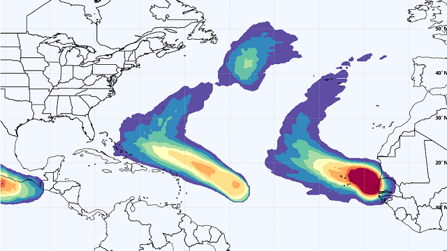
NEXT WEEK: We are looking at some routine weather Tuesday through Friday of next week with partly sunny, warm, humid days and scattered, mostly afternoon and evening showers and thunderstorms. Highs will be between 85 and 89 degrees most days.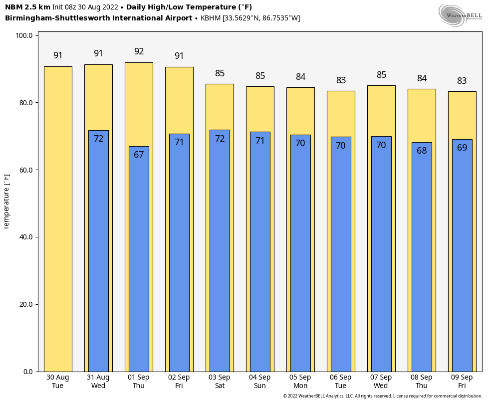 TROPICS: The National Hurricane Center is monitoring just two tropical waves, one in the Atlantic about 875 miles east of the Lesser Antilles and the other one just coming off the coast of Africa. Both will likely develop into either a tropical depression or storm over the next five days, but upper-air winds will also turn both north and northeast into the open Atlantic well before getting close to the U.S. The Gulf of Mexico will remain quiet, and tropical storm formation is not expected there for at least the next seven to 10 days.
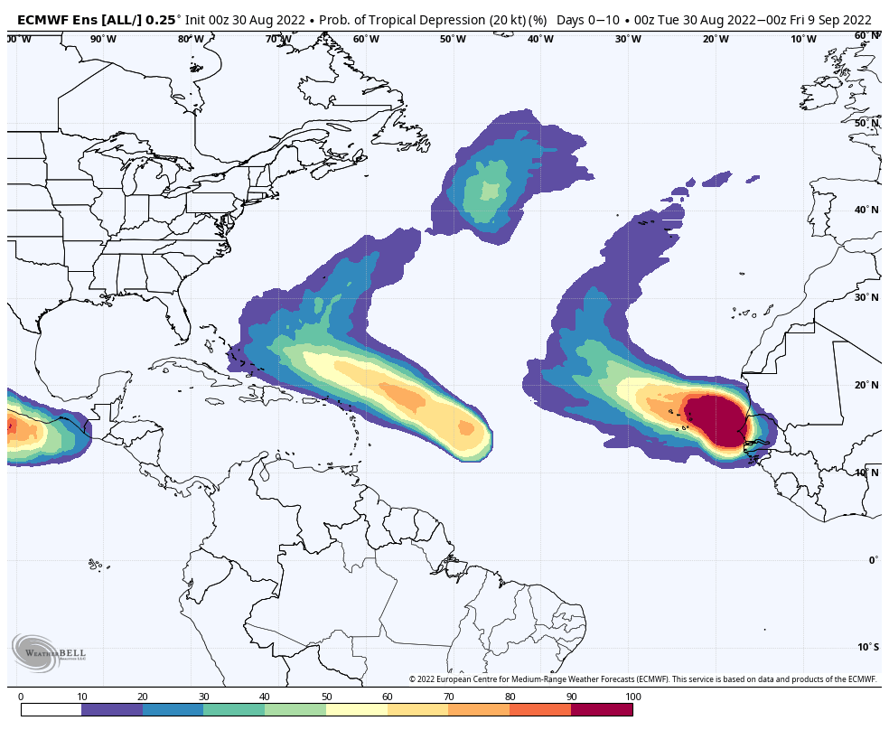 FOOTBALL WEATHER: UAB kicks off its season Thursday, hosting Alabama A&M at Protective Stadium in downtown Birmingham (7 p.m. kickoff). The sky will be clear with temperatures falling from near 83 at kickoff into the 70s by the second half.
Auburn begins its season Saturday, hosting Mercer at Jordan-Hare Stadium (6 p.m. kickoff). A shower or storm can’t be ruled out during the first half; otherwise the sky will be mostly cloudy and the temperature about 85 at kickoff, falling into the upper 70s by the final whistle.
Alabama also plays Saturday, hosting Utah State at Bryant Denny Stadium (6:30 p.m. kickoff). A passing shower or storm is possible during the first half; otherwise it will be a warm, humid night with temperatures falling from the mid 80s at kickoff into the upper 70s by the end of the game.
ON THIS DATE IN 2002: Typhoon Rusa dumped torrential rains across South Korea, causing widespread flooding from Aug. 30 through Sept. 1. Rusa was the most powerful typhoon to hit South Korea since 1959. Nearly 90,000 people were evacuated. The province of Gangwon was hit the hardest, where an estimated 36 inches of rain fell in less than 48 hours. The torrential rains flooded nearly 36,000 homes.
BEACH FORECAST: Click here to see the AlabamaWx Beach Forecast Center page.
For more weather news and information from James Spann and his team, visit AlabamaWx.


