Scott Martin: Strong to severe storms continue in Alabama through the morning
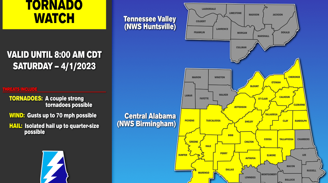
STORMS TODAY: A tornado watch is in effect until 8 a.m. for Autauga, Bibb, Blount, Calhoun, Cherokee, Chilton, Clay, Cleburne, Coosa, Dallas, Elmore, Etowah, Greene, Hale, Jefferson, Marengo, Perry, Randolph, Shelby, St. Clair, Sumter, Talladega, Tallapoosa and Tuscaloosa counties in central Alabama.
A line of strong to severe storms will continue to push through the state, with the threat of severe weather coming to an end around or just before noon in the southeastern parts of central Alabama. After the storms end, skies will begin to clear out and highs will make it into the mid 70s to the lower 80s.
SUNDAY: Sunday will start off with mainly sunny skies, but clouds will begin to build late in the day and during the evening. By late evening through overnight, there will be a chance of a few showers and thunderstorms. Highs will be in the lower to mid 70s.
NEXT WEEK: A wet pattern sets up for the work week ahead. A warm front moves through the state on Monday and Tuesday that will keep showers and thunderstorms in our forecast for both days. Highs will be in the 70s Monday and in the 80s Tuesday.
On Wednesday, a cold front will begin to work through the state, and we may have to watch for the threat of strong to severe storms. The good news is the low associated with the front will be up around the Great Lakes, so the threat will not be as high as we are seeing this morning. We’ll get a better idea on threats and timing once the higher-resolution models come in. Highs will be in the 80s.
The front looks to stall out over the central or southern parts of the state, which will keep our weather unsettled to end the week. Showers and storms will be possible both Thursday and Friday, with highs in the upper 60s to the lower 80s on Thursday and the lower 70s to the mid 80s on Friday.
For more weather news and information from James Spann, Scott Martin and other members of the James Spann team, visit AlabamaWx.


