James Spann: Showers return to Alabama today; a few strong storms possible
James Spann forecasts showers and storms, some possibly strong, across Alabama today from Alabama News Center on Vimeo.
ON THE MAP: A well-defined upper low is spinning away this morning over Louisiana, and on the east side of the system moist air continues to move northward. Showers are fairly widespread across central Alabama early this morning, and additional showers and a few thunderstorms will form this afternoon.
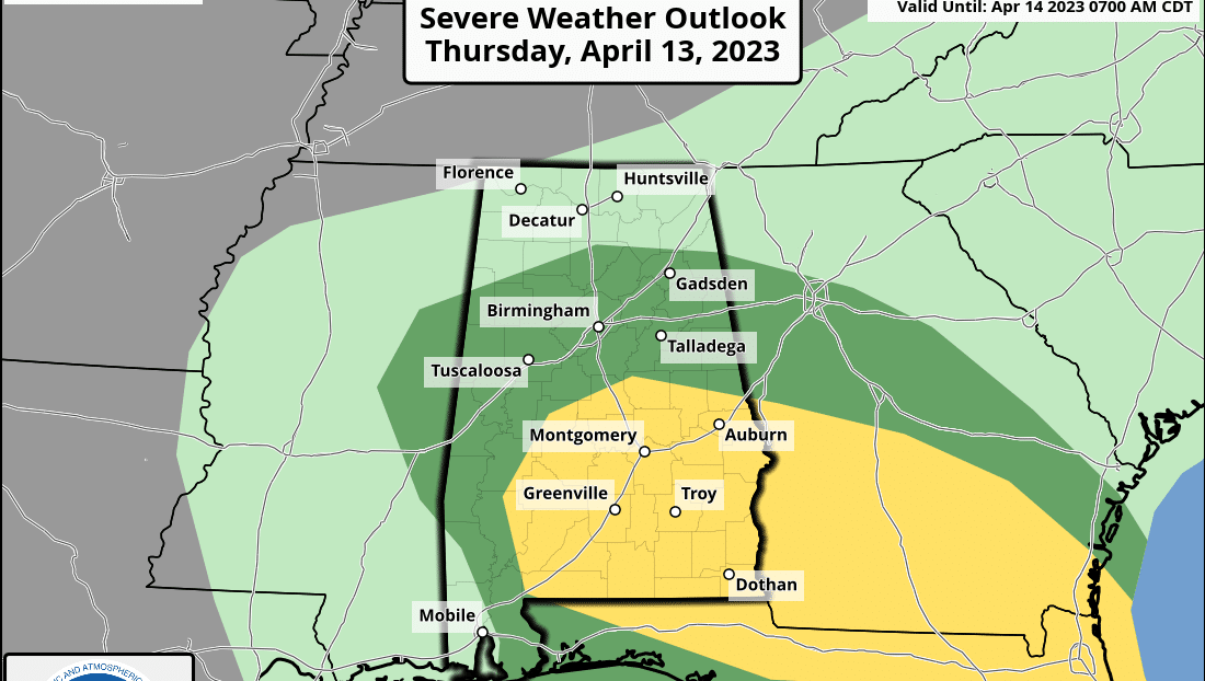
The Storm Prediction Center has defined a slight risk (level 2 out of 5) of severe thunderstorms for areas south and east of a line from Atmore to Clanton to Opelika. A marginal risk (level 1) extends as far north as Vernon, Cullman and Centre.
Storms this afternoon and evening could produce small hail and gusty winds. An isolated, brief tornado can’t be ruled out but isn’t likely. The highest risk of a tornado this afternoon is over southeast Alabama, where instability is a little higher. The main window for the stronger storms will come from about 1 until 7 p.m.
This certainly isn’t a major threat, but you have to watch any system that rolls through here in mid-April. The high today will be between 65 and 75 degrees with a mostly cloudy sky.
FRIDAY AND THE WEEKEND: We will maintain the chance of scattered showers Friday, but much of the day will be dry. The sky will remain mostly cloudy with highs generally in the upper 60s and low 70s. Saturday looks warm and dry for much of the state, with a high in the low 80s. The exception is the southwest corner of the state, where rain is possible across Mobile and Baldwin counties.
A cold front will bring showers statewide late Saturday night into Sunday morning. A few strong storms are possible initially over the northwest corner of the state, but they should be weakening and, for now, severe storms are not expected. The main window for rain with this feature will come from about midnight Saturday night to noon Sunday. Some clearing is possible Sunday afternoon over west Alabama. Highs will remain between 67 and 74 degrees.
NEXT WEEK: Most of the week looks warm and dry with sunny days and fair nights. Highs will be in the 70s Monday and Tuesday, with low to mid 80s over the latter half of the week. A few showers could return Friday, but for now it doesn’t look like a major rain event. ON THIS DATE IN 1999: A 2-mile-wide area of wind-driven hail pounded residences and farm equipment for about a 5-mile stretch at least as far as State Highway 158 in west Texas near Midland and Odessa. Hail grew to about golf-ball size and winds peaked at approximately 80 mph. The wind-driven hail broke windows in houses and blasted paint off the wooden siding.
ON THIS DATE IN 2006: An F2 tornado hit Iowa City, Iowa, and trekked across southeastern parts of the University of Iowa campus, doing more than $15 million damage, hurting 30 people and damaging or destroying 1,051 buildings.
BEACH FORECAST: Click here to see the AlabamaWx Beach Forecast Center page.
For more news and information from James Spann and his team, visit AlabamaWx.


