James Spann: Scattered storms return to Alabama statewide today; heat levels rise next week
James Spann forecasts typical summer weather for Alabama, with scattered storms, heat from Alabama News Center on Vimeo.
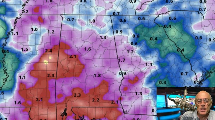
SUN AND STORMS: Moisture levels will rise across Alabama today, and we will mention a chance of scattered showers and thunderstorms statewide this afternoon and early tonight. They will be most numerous over the western half of the state; otherwise, expect a partly sunny sky with a high between 88 and 92 degrees. The average high for Birmingham on July 12 is 91.
An ocean of humidity will cover the Deep South Thursday through the weekend, and we expect scattered to numerous showers and thunderstorms during the afternoons and evenings (mostly between 2 and 10 p.m.). The chance of any one location seeing rain daily is 50-60%; otherwise, we expect a mix of sun and clouds daily with highs generally in the low 90s.
NEXT WEEK: A strong upper ridge will build in from the west, meaning rising heat levels and fewer showers. The chance of any neighborhood seeing a shower or storm daily will drop to around 15-20%, and highs will rise into the mid 90s — maybe upper 90s in spots, especially on the western side of the state. Heat advisories will be needed as the heat index will be over 100 daily.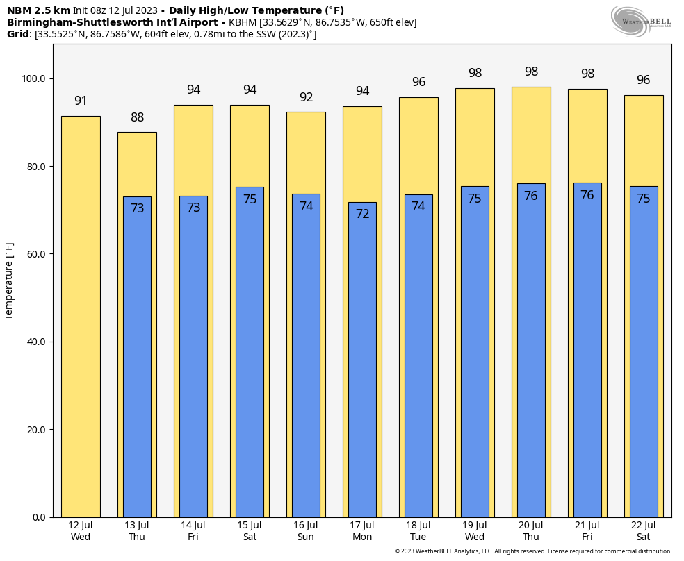 TROPICS: A small area of low pressure more than 500 miles east-northeast of Bermuda continues to produce disorganized showers and thunderstorms well to the south of its center. Environmental conditions are forecast to be marginally conducive for some development of this system, and a subtropical or tropical depression or storm could form during the next few days while the system moves generally eastward. By the weekend, the low should turn northward, bringing the system over cooler waters and potentially limiting additional development. The National Hurricane Center gives it a 50% chance of development over the next five days; one way or another, it will remain far from land.
The rest of the Atlantic basin, including the Gulf of Mexico, remains very quiet.
ON THIS DATE IN 1995: An intense heat wave affected much of the Midwest for a four-day period beginning on this day. The worst effects of the heat were noted in the Chicago metropolitan area, where 583 people died from it. Temperatures across the region reached as high as 104 degrees.
ON THIS DATE IN 1996: Hurricane Bertha made landfall near Wrightsville Beach, North Carolina, with maximum winds of 105 mph, but the storm surge dealt the most devastation. The U.S. Virgin Islands and North Carolina were declared federal disaster areas. Surveys indicate that Bertha damaged almost 2,500 homes on St. Thomas and St. John. For many it was the second hit in 10 months, since Hurricane Marilyn had devastated the same area. The primary effects in North Carolina were to the coastal counties and included storm surge flooding and beach erosion, roof damage, piers washed away, fallen trees and damage to crops.
For more weather news and information from James Spann and his team, visit AlabamaWx.


