Brian Peters: A little dry time for central Alabama
The strong closed upper low that moved out of East Texas yesterday was located over the Great Lakes this morning. The surface weather map featured a surface high over the Red River Valley with the cold front that moved through Alabama yesterday situated along but just west of the US East Coast.
This pattern should bring Alabama at least one dry day before clouds and rain return late today and early Wednesday. The great heat wave of Christmas 2015 is history with the highs today expected to be around 60 degrees – and that should feel pretty nice.
Brian Peters forecast for Alabama Newscenter December 29 from Alabama NewsCenter on Vimeo.

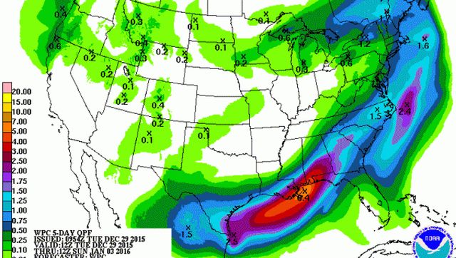
With a continuation of a southwesterly flow aloft, the cold front will drift northward later today and tonight with more rain forecast for Alabama. QPF forecasts suggest an additional 1 to 3 inches especially across the southern sections of Alabama. These areas are already saturated from previous rains, so whatever flooding is going on today is likely to become worse due to the addition of more rain.
The rainfall gradient will be from southeast to northwest across Alabama with the least amount of rain expected in the northwest corner of the state. Across Central Alabama, rainfall amounts of one half to 2 inches will be possible. Temperatures Wednesday will stay relatively mild with highs around 60.

For those headed to the Birmingham Bowl at Legion Field, you’ll be wise to take rain gear with periods of rain a good possibility.
The temperatures are expected to be in the middle and upper 50s throughout the game pitting Auburn against Memphis.
With the front stalled or drifting in the vicinity of the Gulf Coast, weather at the beach for the next week or so is not going to be very good. Showers are likely through New Year’s Day with some chance of showers after that. Temperatures will be spiraling downward with highs around 70 today and Wednesday, in the 60s Thursday, and in the 50s into the first weekend of 2016.
Fortunately, even with a surface front in the vicinity of South Alabama and a series of short wave moving across the Central US, there is very little if any risk for severe weather for the next several days.
For much of Central Alabama, rain chances should be diminishing early Thursday with mainly a rain-free forecast into the first weekend of 2016. But as the long wave trough position is carved out across the eastern US, it will be turning appreciably colder for us. Highs Thursday and Friday will be in the 50s, but into the weekend our high temperatures will struggle to get out of the 50. By the weekend, we’ll also see morning lows dipping back to and slightly below the freezing mark again.

But do not fear, the cold is not forecast to last long. By Monday the upper flow goes zonal and then southwesterly on Tuesday in response to another strong short wave coming into the Southwest US and northern Mexico. That should allow our temperatures to come back up with lows in the middle and upper 30s while highs will climb back into the 50s. These values are just about right for what we typical expect to see in early January.
It looks like we should stay dry for much of the voodoo period. The main upper air action will be well north of us as well as well west of us. The GFS at 348 hours has an intriguing pattern with a very low latitude upper closed low coming across northern Mexico. This could bring another wet pattern to the Southeast US and the Lower Mississippi River Valley. This kind of pattern also presents some risks for a bout of wintery weather, but it is much too early to give any specifics – just a bit of pattern recognition. As most readers know, the long range charts are likely to change significantly long before we get out that far.
For more weather information, go to Alabamawx.com.


