Brian Peters: Wet again in Alabama!
Brian Peters Alabama NewsCenter weather forecast for December 30 from Alabama NewsCenter on Vimeo.
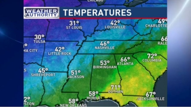
Weather turned wet again overnight as the frontal boundary to our south migrated northward a little bringing rain back into Central and South Alabama. Temperatures moderated again with lows this morning dipping only back into the 50s. Clouds along with off and on rain can be expected today with temperatures changing little with our highest temperatures today only in the middle and upper 50s.
There is not enough instability to generate more than an isolated thunderstorm and SPC has no area identified for any severe weather. The big threat will be the rain which is falling on already saturated soil. Flash flooding will be the main danger we face through Friday especially in areas where heavier storms train dumping excessive amounts of rain. Total rainfall anticipated is around 2 to 4 inches mainly across the southern third of Alabama. Rainfall will taper off to one quarter to 1 inch amounts across Central Alabama with less than a half inch across the Tennessee River Valley.

The upper air pattern will gradually morph into a trough over the eastern half of the country as we head into Friday and the weekend. A series of upper air short waves will gradually dig out a long wave trough position for the weekend over the eastern US which will finally bring an end to the wet weather and bring colder air into the picture. By Saturday and Sunday morning, I expect to see morning lows dip below freezing with readings generally 28 to 32 but with those colder locations reaching the middle 20s. Daytime highs for the weekend will be much colder than we’ve seen recently with highs struggling to get out of the 40s especially Saturday.
The upper air trough will stick around through Monday but be edged out on Tuesday but an upper ridge. The upper ridge does not last long as another strong short wave comes out of the Southwest US and promises our next shot at rain by Wednesday, January 6th.
Beach goers will see showers and thunderstorms a part of the picture along the beaches of Alabama and Northwest Florida for the rest of the year. Shower and thunderstorm chances will remain high until the start of 2016 when rain chances will drop back into the slight chance category into the weekend. Conditions will improve by late in the weekend, at least in the clouds and rain department. But the mercury will be trending downward. Expect highs around 70 today. Thursday will see 60s and then 50s will settle in for Friday and the weekend. Lows will drop into the 50s Thursday morning with weekend lows in the 40s.
For football enthusiasts, be sure to take the rain gear if you are headed for the Birmingham Bowl today. Rain is expected to come and go just about anytime during the game. Temperatures will be mainly in the middle 50s for the game at Legion Field that begins at 11 this morning.
Alabama fans headed to Arlington, TX, for the Cotton Bowl and College Football Playoff Semifinal will experience cool and mostly dry conditions for the rest of the week. Highs will be mainly in the 40s and lows in the 30s. There is a small chance of light sleet Thursday night and Friday morning under mostly cloudy skies. The rest of the week into the weekend will be mostly cloudy.
Looking further out into voodoo country, the ridge comes back around the 8th of January for a short appearance before another strong short wave trough comes out of the Southwest US again on the 10th that may bring a shot of rain. The overall upper air pattern goes into a trough over the eastern US again around the 13th spelling another period of chilly weather for Alabama.
Thanks for staying tuned to the weather through the Alabama Weather Blog. Stay dry and Godspeed.
-Brian-

For more weather news and information from Brian Peters and the rest of the James Spann weather team, visit Alabama WX.
