James Spann: Nice warm-up today in Alabama
James Spann Alabama NewsCenter Weather Forecast February 18 from Alabama NewsCenter on Vimeo.
COLD START: Most North/Central Alabama communities are in the 30s as the day begins, but some of the colder pockets have slipped into the upper 20s with a clear sky and light wind. But, the air over Alabama is very dry, and temperatures will rise quickly today…. we wind up in the 60s this afternoon with a good supply of sunshine.
Tomorrow will be another sunny day with a high in the 67-70 degree range.
THE ALABAMA WEEKEND: A weak front will approach from the north, but it looks like Saturday will be mostly rain-free with only a small risk of a few showers near the Tennessee border. Otherwise, we will forecast a mix of sun and clouds with a high between 67 and 70.
Showers become a little more likely Sunday afternoon over the northern third of the state as the front drifts to the south, but still nothing too widespread or heavy. Sunday will feature more clouds than sun with a high in the 60s.
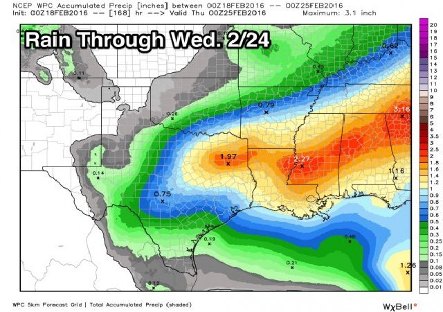
SOAKER EARLY NEXT WEEK: A wave of low pressure forms on the front, and our weather looks very wet Monday and Tuesday. Rain totals by Tuesday night could easily be over two inches in many places. Some thunder is possible, but severe weather isn’t expected with the surface low passing right over us. We will reach the 60s Monday, but hold in the 50s all day Tuesday.

Wednesday will be breezy and cool with gradual clearing, along with a high in the 50s. Then, dry weather is the story Thursday and Friday with a warming trend. See the Weather Xtreme video for maps, graphics, and more details.

WEATHER BRAINS: Don’t forget you can listen to our weekly 90 minute netcast anytime on the web, or on iTunes. This is the show all about weather featuring many familiar voices, including our meteorologists here at ABC 33/40.
CONNECT: You can find me on all of the major social networks…
Facebook
Twitter
Google Plus
Instagram
For more weather information, visit Alabamawx.com.


