James Spann: The warm-up begins across Alabama
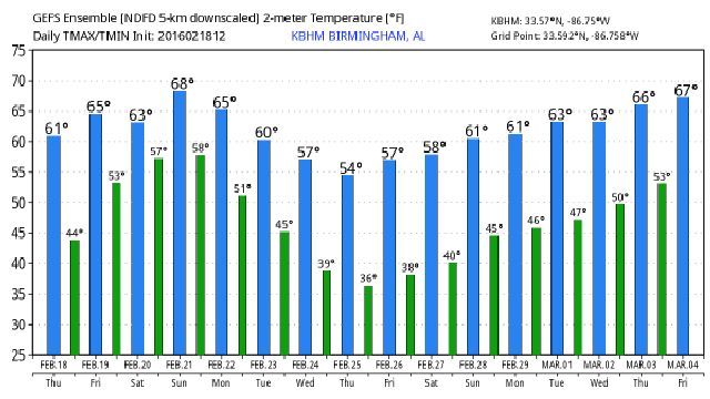
FINE DAY: As advertised, temperatures in the 60s across the great state of Alabama this afternoon with hardly a cloud in the sky. Tomorrow will be even warmer with a high in the 67-70 degree range, and the sky will remain mostly sunny.
THE ALABAMA WEEKEND: A weak surface front will drift down to near the Alabama/Tennessee border Saturday evening; I do think we will need to mention a chance of showers Saturday afternoon and into Saturday night over the northern third of the state, mainly along and north of U.S. 278 (Hamilton to Cullman to Gadsden). Nothing too heavy, and the rest of the state should be dry with a high between 67 and 70.
Showers should be a little more extensive Sunday afternoon as a wave of low pressure begins to form along the front west of the state, but it won’t rain all day, and the weather stays mild with a high between 67 and 70 once again.
NEXT WEEK: No doubt Monday will be a wet day, with periods of rain and maybe a little thunder in spots. Forecast confidence drops a bit Tuesday as the new European model run (12Z) gives a much drier look for Alabama. We will keep the chance of rain going on Tuesday for now, and indicate rain potential of 1 to 2 inches for most of the state. Drier air arrives Wednesday, and we stay dry for the rest of the week with highs close to 60 degrees.
Still no sign of any winter weather issues, or severe weather threats for Alabama for the rest of February, but I caution you we ALWAYS have cold snaps in March. Winter isn’t over.
See the Weather Xtreme video for maps, graphics, and more details.

WEATHER BRAINS: Don’t forget you can listen to our weekly 90 minute netcast anytime on the web, or on iTunes. This is the show all about weather featuring many familiar voices, including our meteorologists here at ABC 33/40.
CONNECT: You can find me on all of the major social networks…
Facebook
Twitter
Google Plus
Instagram
For more weather information, visit Alabamawx.com.