James Spann: Cool, soaking rain begins tomorrow in Alabama
VERY BENEFICIAL RAIN AHEAD: Clouds increase across Alabama tonight, and rain will move in from the west during the day tomorrow. Rain should reach the I-65 corridor by midday, and on into East Alabama by mid-afternoon. Then, a soaking, chilly rain will fall tomorrow night and Sunday. The high tomorrow will be only in the 50- to 55-degree range, and many communities north of Birmingham won’t get out of the 40s Sunday with the steady rain continuing to fall.
STRONG STORMS EARLY NEXT WEEK: On Monday a surface low over Louisiana will move northeast, to a position near Nashville by Tuesday morning. A warm front will be moving northward, and there is a chance the “warm sector” moves as far north as I-20 by Monday night. This could set the stage for strong to severe thunderstorms over the southern two-thirds of Alabama. For now the Storm Prediction Center has the severe weather threat confined to the far southwest corner of the state, but that will probably be pulled northward at some point. We will keep a close eye on severe weather parameters over the weekend and we can be more specific about the threat, if one develops.
Rain and storms will end Tuesday morning as a slot of dry air rotates into the state.
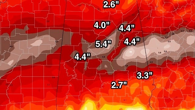
Model guidance suggests 4 to 5 inches of rain is very possible, if not likely, between tomorrow and Tuesday. This will take a big chunk out of rain deficiencies statewide; Birmingham still needs 11.51 inches to get back to average values and end the drought.


ARCTIC BLAST LATER NEXT WEEK: An Arctic front will blow in here Wednesday, and most likely it will come through in dry fashion. Then, the coldest air so far this season will settle in here Thursday, when the high will be only in the low 40s with a biting north wind of 15 to 30 mph. Then, next Friday, some places up in the Tennessee Valley of far North Alabama will stay below freezing all day, with highs in the mid to upper 30s for Birmingham, Tuscaloosa, Anniston and Gadsden. Early morning lows should reach the teens in the Dec. 9-10 time frame.
NO-BURN BAN REMAINS IN EFFECT: We received this news release from the Alabama Forestry Commission this afternoon:
“The statewide Drought Emergency ‘No Burn’ Order declared by Gov. Robert Bentley in early November will remain in effect until conditions change sufficiently to reduce the occurrence and frequency of wildfires. Despite a nice coverage of rain across much of the state this week, the governor and officials with the Alabama Forestry Commission (AFC) remain cautious.
“’We are grateful for the rainfall we’ve received, but because of the severe prolonged drought it is just too soon to lift the ‘No Burn’ Order,’ explained Interim State Forester Gary Cole. ‘The winds and lower relative humidity accompanying the cooler temperatures we’re experiencing combine to quickly dry out vegetation, which will increase the probability of dangerous wildfire activity until the next rain event. We’re certainly hoping the weather forecast of additional rain through early next week is correct, and we will reassess the situation at that time.’
“’After seeing the recent devastation in our sister state of Tennessee, we cannot afford to take any risks,’ Bentley said. ‘The bottom line is that Alabama is still in an extreme drought. Until the threat of catastrophic wildfires is considerably reduced, we do not want to be too hasty in making a decision. Several recent wildfires across our state have threatened residential areas, and if not for the efforts of the Alabama Forestry Commission firefighters and volunteer fire departments, we would have lost homes. Their commitment to protecting life, property and wildlife is greatly appreciated.’
“Year-to-date, a total of 3,644 wildfires have consumed almost 50,000 acres of land in Alabama, with 2,219 of those fires and 29,406 acres just since Oct. 1. ‘This past Monday 108 active wildfires burned over 3,000 acres across the state, setting a record for one day. This situation was extremely alarming, not only because of the unusually high number of fires but also because of their large size,’ continued Cole. ‘It was a nightmarish day and night, stretching the men and women who make up our wildfire suppression resources beyond capacity.’”
WEATHER BRAINS: You can listen to our weekly 90-minute netcast anytime on the web, or on iTunes. This is the show all about weather featuring many familiar voices, including meteorologists at ABC 33/40.
CONNECT: You can find me on all of the major social networks:
Facebook
Twitter
Google Plus
Instagram
For more weather news and information, visit AlabamaWX.


