James Spann: Warm and dry tomorrow; storms return to Alabama Thursday
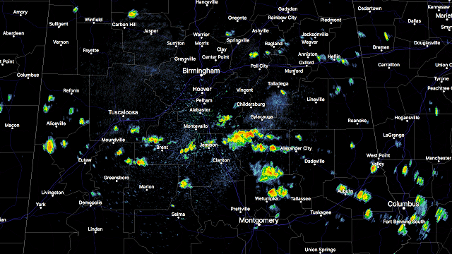
RADAR CHECK: As expected, we have a few widely scattered showers across Central Alabama this afternoon in the moist, unstable environment. Nothing too heavy or widespread.

Otherwise, we have a mix of sun and clouds with temperatures in the 70s. The showers will end this evening once the sun goes down.
Tomorrow will be warm and dry; we rise into the low 80s with a partly sunny sky. The chance of a shower is so small we won’t mention it in the forecast. To the west, severe storms are possible across the ArkLaTex region with the next upper trough moving along in the active spring wave train across the southern U.S.
STORMS RETURN LATE THURSDAY: We will mention a good chance of showers and thunderstorms late Thursday afternoon, Thursday night and into Friday morning. The Storm Prediction Center has much of the state in the standard “slight risk” of severe weather, with a “marginal risk” for East Alabama.

The synoptic scale pattern favors strong to severe storms, with a surface low over Missouri and a moist, unstable airmass in place over Alabama. The morning runs of the Global Forecast System and North American Mesoscale models are still showing a mass of storms near the Gulf Coast Thursday night, which would reduce the southerly flow across North Alabama and accordingly mitigate the severe weather threat. But the European model doesn’t show the Gulf mass of storms, and the model madness makes for a low-confidence forecast.
For now we will simply mention a good chance of showers and storms from about 4 Thursday afternoon through 9 Friday morning; some of the storms could be strong to severe. We should have better clarity on the magnitude of the threat tomorrow.
THE WEEKEND: Looking good; we expect ample sunshine Saturday and Sunday with highs in the 70s. Early morning temperatures will be in the cool 40s and 50s.
NEXT WEEK: The first part of the week looks stormy, with a good round of showers and storms Monday afternoon, Monday night and into part of the day Tuesday, but it is simply way too early to determine the severe weather risk in this active pattern.

LAST FROST/FREEZE? I still expect one more run at frost and a freeze by mid April. Too early to plant anything that might be harmed by a freeze, in my opinion. Easter cold snaps are almost a given here in Alabama.
Click here to see the Beach Forecast Center page.
STORM SPOTTER TRAINING IN OXFORD TONIGHT: We will be on the road through early April offering free storm spotter classes. We need more trained spotters in Alabama. By attending, you can make the severe weather warning process better. No need to register; just come with a curious mind. And there is no age limit; kids who love weather will enjoy it. You will never look at a storm the same again. This week we are at Oxford this evening (at the Oxford Civic Center) and Jasper Thursday (at the Jasper Civic Center). Sessions begin at 6:30 p.m.
WEATHER BRAINS: You can listen to our weekly 90-minute netcast anytime on the web, or on iTunes. This is the show all about weather featuring many familiar voices, including meteorologists at ABC 33/40.
CONNECT: You can find me on all of the major social networks:
Facebook
Twitter
Google Plus
Instagram
Pinterest
Snapchat: spannwx
For more weather news and information, visit AlabamaWX.