James Spann: Severe storms possible in Alabama later today, tonight
James Spann: Statewide risk of severe storms for Alabama later today from Alabama NewsCenter on Vimeo.
COMPLEX SETUP: There is a risk of severe weather statewide today as a large-scale upper trough approaches from the west. A surface low will be near St. Louis this afternoon, and all of Alabama is in the “warm sector” of the system. While the synoptic scale pattern favors severe storms, the mesoscale features will determine what ultimately happens.
We have an area of rain and storms over southeast Mississippi early this morning, and that will move into South Alabama in a few hours. There is a chance this will disrupt the inflow of warm, moist air into the northern half of the state, and also reduce the instability due to clouds and limited surface heating today. This, in turn, would result in a lowered overall severe weather threat. However, there is also a chance activity over South Alabama could dissipate. Model guidance has not been consistent, so uncertainty remains concerning the evolution of thunderstorms over our state late this afternoon and tonight.
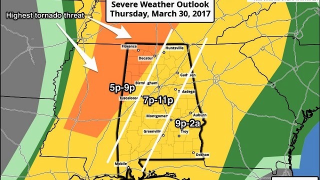
The Storm Prediction Center has removed the “moderate” severe weather risk (category 4) for far northwest Alabama today, but maintains an “enhanced” risk (category 3) west of a line from Athens to Carbon Hill to Gordo. The rest of the state is in a “slight” risk (category 2).


THREATS: The highest tornado probability remains in the “enhanced” risk area of northwest Alabama. A few isolated tornadoes, however, are possible statewide. Stronger storms will also be capable of producing hail and strong straight-line winds.
TIMING: The primary severe weather threat for northwest Alabama will come from 5 p.m. until 9 p.m.; for places like Birmingham, Tuscaloosa, Anniston and Gadsden, the main window will be from 7 p.m. to 11 p.m.; and for east Alabama, from 9 p.m. until 2 a.m.
RAIN: Rain amounts of one-half to 1 inch are expected; no flooding issues.
CALL TO ACTION: Be sure you have a way of getting warnings; a NOAA Weather Radio is the baseline, and a good smartphone app is the other tier. Identify the safe place in your home, and be sure everyone knows where it is. In that safe place, have helmets for everyone, along with hard-sole shoes and preferably a portable airhorn in case you need help.
Be sure you have the ABC 33/40 app on your phone so you can watch our live severe weather coverage, if needed:
Rain and storms end late tonight as drier air pushes into the state.
TOMORROW THROUGH SUNDAY: Tomorrow and Saturday will be delightful spring days, with ample sunshine. The high will be in the mid 70s tomorrow and close to 80 Saturday afternoon. We project a mix of sun and clouds Sunday with a high between 77 and 80; showers and storms could creep into the state Sunday night.
NEXT WEEK: Rain and storms are likely Monday. The latest Global Forecast System run suggests the surface low will pass across Central Alabama; if that is the case, the main severe weather threat will be near the Gulf Coast, although North Alabama could see heavy rain. This could easily change, however; it’s just too early to be specific. And yet another chance of strong storms shows up late Wednesday and Wednesday night as the wave train keeps cranking out the hits.

Click here to see the Beach Forecast Center page.
STORM SPOTTER TRAINING: We will be on the road through April offering free storm spotter classes. We need more trained spotters in Alabama. By attending, you can make the severe weather warning process better. No need to register; just come with a curious mind. And there is no age limit; kids who love weather will enjoy it. You will never look at a storm the same again. The next training is in Tuscaloosa Tuesday evening at 6:30 at Shelton State Community College.
WEATHER BRAINS: You can listen to our weekly 90-minute netcast anytime on the web, or on iTunes. This is the show all about weather featuring many familiar voices, including meteorologists at ABC 33/40.
CONNECT: You can find me on all of the major social networks:
Facebook
Twitter
Google Plus
Instagram
Pinterest
Snapchat: spannwx
For more weather news and information, visit AlabamaWX.


