Brian Peters: Windy with storms Sunday night, early Monday in Alabama
Brian Peters: Two storm systems headed for Alabama late Sunday, Thursday from Alabama NewsCenter on Vimeo.
MILD MORNING, WINDY DAY: Weather conditions are somewhat tranquil across Alabama this morning. Temperatures were very mild for late April, in the lower 70s just before 6 a.m. Highs today should climb into the upper 80s.

The big news today will be the warm weather, together with high wind. Much of Alabama and Mississippi are under wind advisories today as the pressure gradient tightens up between the surface high to the east over the Atlantic and the surface low over North Central Texas. The tightening pressure gradient and the onshore flow were setting up excellent conditions for rip tides along the beaches of Mississippi, Alabama and Northwest Florida, so if you are at the beach or headed that way, be very careful about swimming in the Gulf of Mexico.
SUNDAY STORMS: The weather will be fairly good for much of the daylight hours Sunday, notwithstanding the wind issue, as a strong southerly wind will continue. Clouds will increase, so temperatures should be held down into the lower and middle 80s. The strong closed low over New Mexico on Saturday will begin to pull northeastward, reaching central Kansas by midday Sunday. The surface low will reach northeast Kansas, with the front pushing well eastward to the Mississippi River by midday. Much of the eastern two thirds of Alabama is under a slight risk for severe storms late Sunday afternoon through early Monday morning. CAPE and helicity values support the potential for all modes of severe weather. While it looks like we’ll be dealing with a squall line, model soundings suggest the potential for tornadoes embedded in that line.
NEXT WEEK: The upper low reaches Wisconsin on Monday as the front approaches the East Coast. The weather across Alabama should improve throughout the day, with the potential to see some sunshine by late afternoon. Temperatures will fall back plenty as northwesterly flow begins to affect the area, with highs only in the 70s – actually quite nice.
The upper air pattern flattens a little Tuesday, and we see upper air ridging on Wednesday. By Wednesday, though, our attention is drawn to another strong trough digging into the Texas Panhandle. By Thursday the trough has dug into eastern Oklahoma and closed off with a surface low over Memphis. This certainly has the look for another round of severe storms on Thursday, but since there are still model differences and several timing issues, no specific area has been outlined yet. Maybe we’ll see an area defined as we get closer to the event and differences in the model solutions resolve themselves.
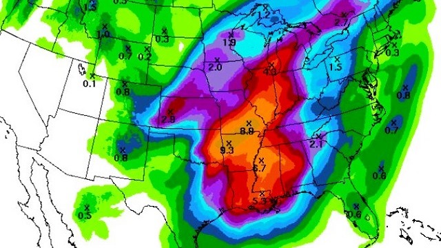
So look for another round of storms mainly on Thursday. Rainfall through these two systems could be substantial. Quantitative Precipitation Forecast charts suggest 2 to 4 inches of rain is possible across the northern half of Alabama through Thursday morning.

The upper closed low is going to take its time as it moves slowly across the Southeast on Friday, keeping the weather unsettled and cool with highs only in the 60s. The low finally reaches northwest Georgia on Saturday, so our weather should be improving and warming up.
AT THE BEACH: Weather at the beach will be fine today, but the strong onshore flow is setting up excellent conditions for rip tides, and the onshore flow will keep rip tides likely through early Monday. Storms are likely Sunday afternoon into Monday morning. Temperatures remain nice, with highs around 80. Click here to see the Beach Forecast Center page.
Be sure to come out to Celebrate Hoover Day at Veterans Park today. I’ll be there at the ABC 33/40 booth, so stop by and say hello. Have a great day, don’t get blown away and Godspeed.
 For more weather news and information from Brian Peters, James Spann and the rest of the James Spann team, visit AlabamaWX.


