James Spann: Cindy to soak Alabama through Friday
James Spann: Get ready for a drenching, Alabama from Alabama NewsCenter on Vimeo.
RADAR CHECK: The leading edge of the large rain mass associated with Tropical Storm Cindy is from Eutaw to Brent to Clanton to Dadeville early this morning and slowly moving northward. South Alabama has been in a soaking rain through the night, and all of Alabama will see excessive rain over the next three days.
CINDY STATS: Tropical Storm Cindy is in the Gulf of Mexico in a highly sheared environment. Sustained winds have increased to 60 mph, but the system is not expected to reach hurricane strength, and landfall should come early tomorrow morning near the Sabine Pass — the Texas/Louisiana border. The track is not that important to us in that the impact will extend 500 to 600 miles to the east, as deep multilayered tropical moisture is pulled up into the Gulf Coast states.
The main issues with Cindy will come from heavy rain, flooding, rough surf and rip currents, and isolated tornadoes east of the circulation center.
Here is a look at the expected impact for our state.
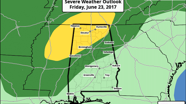
NORTH/CENTRAL ALABAMA: As expected, the flash flood watch has been pulled northward into central Alabama. The flash flood watch includes the Birmingham metro area and points west and south. Expect long periods of soaking tropical rain today, tonight, and tomorrow with 2 to 4 inches likely; isolated amounts to 5 inches are possible. If you live in a flood-prone area, pay attention to flash flood warnings.
Showers and storms are likely at times Friday as well, but it won’t rain all day.
In addition to the flooding threat, as Cindy moves inland shear values will rise significantly, and we will have the risk of a few isolated tornadoes both tomorrow and Friday. Tornadoes associated with a tropical system tend to be short lived, and mostly in the EF-0/EF-1 category. But they are still dangerous.
We need to stress it is very challenging to issue warnings for these tornadoes since many of them last only for a few minutes, and because of the low-topped nature of the convection, they are often “under the radar” and not detectable. Just pay very close attention to the weather and be aware of this possibility.

A few showers and storms are still likely Saturday, but drier air creeps into the state Sunday, with few showers and an increasing amount of sunshine. Highs over the weekend will be in the low to mid 80s.
CENTRAL GULF COAST: We note one report already of more than 6 inches of rain near Pensacola, and additional rain amounts of 8 to 10 inches are likely from Dauphin Island over to Gulf Shores and Pensacola. Additional amounts of 4 to 6 inches are likely for Destin and Panama City Beach through tomorrow.
The National Weather Service in Mobile is calling this an “extreme flooding threat” that is life threatening.

In addition to serious flooding, waterspouts and tornadoes are possible on the Gulf Coast today. A tornado watch is in effect until 10 a.m., and that will most likely be extended through the rest of the day and into tonight.

A tornado warning was issued early this morning for parts of Oklaloosa County, but so far I have heard of no damage from that storm.
Be sure you have a way of hearing tornado warnings, and develop a plan at your hotel or condo. You have to get on the lowest floor and away from windows.
Also, double red flags are flying because of extremely dangerous surf and rip currents. From the City of Gulf Shores:
• All Gulf of Mexico waters within the corporate limits of Gulf Shores are closed to the public until further notice.
• Swimming, wading, floating or any other entry into the Gulf of Mexico waters within the corporate limits of Gulf Shores is prohibited.
• Anyone entering the Gulf of Mexico within the corporate limits of Gulf Shores is subject to imprisonment and/or fines.
Showers and storms will begin to thin out on the Gulf Coast Friday with some sun at times, and by the weekend weather will be back to usual summer conditions, with the usual combination of sun and scattered thunderstorms.
NEXT WEEK: Dry air will cover the northern half of the state, and for now there is a good chance we will be shower-free Monday through Wednesday with lower humidity; highs will be in the 80s and lows in the 60s.
REST OF THE TROPICS: Tropical Storm Bret dissipated yesterday, and the rest of the Atlantic basin is quiet.
WEATHER BRAINS: You can listen to our weekly 90-minute netcast anytime on the web, or on iTunes. This is the show all about weather featuring many familiar voices, including meteorologists at ABC 33/40.
CONNECT: You can find me on all of the major social networks:
Facebook
Twitter
Google Plus
Instagram
Pinterest
Snapchat: spannwx
For more weather news and information, visit AlabamaWx.


