James Spann: Showers, storms return to Alabama
James Spann: Alabama gets wet again for the next two days from Alabama NewsCenter on Vimeo.
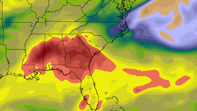
RADAR CHECK: Fairly widespread rain is over the southern half of Alabama early this morning thanks to a disturbance just west of the state, with a few scattered showers over the northern counties. Deep tropical moisture has returned statewide, and that will set the stage for scattered to numerous showers and thunderstorms through tonight. Precipitable water amounts are surging to more than 2 inches, so a few heavy downpours are a good possibility; rain amounts of at least 1 inch are likely over the next 36 hours.
A flash flood watch is in effect for Mobile and Baldwin counties in far southwest Alabama.

With a mostly cloudy sky today, temperatures won’t get past the low 80s. The average high for Birmingham for June 29 is 89.
TOMORROW: Forecasting timing and placement of summer thunderstorms is a great mystery, but we are getting better clarity with short-range mesoscale models. The short wave aloft just west of the state should bring fairly widespread rain to Alabama during the morning, but as the wave moves east of the state, subsidence (downward motion in the atmosphere) should bring a fairly quiet and mostly rain-free afternoon with potential for some sunshine. Tomorrow’s high will be in the low 80s again for most communities.
SATURDAY/SUNDAY: Tropical moisture will remain anchored over Alabama, but with no well-defined triggering mechanism for rain, we will forecast the usual risk of mostly afternoon and evening showers and thunderstorms both days; the chance of any one spot getting wet will be in the 45 to 55 percent category. Most of the showers and storms will come from about 2 until 9 p.m., but we can’t totally rule out a late-night or morning shower. With a mix of sun and clouds, we expect highs in the mid to upper 80s both days.
MONDAY/TUESDAY: The long Fourth of July holiday weekend rolls along, and the weather won’t change much — partly sunny both days with scattered showers and thunderstorms, most likely during the afternoon and evening hours. Highs generally between 87 and 90 degrees.
And not much change for the rest of the week.

TROPICS: Tropical storm formation is not expected across the Atlantic basin through next week.
BEACH FORECAST: Click here to see the AlabamaWx Beach Forecast Center page.
WEATHER BRAINS: You can listen to our weekly 90-minute netcast anytime on the web, or on iTunes. This is the show all about weather featuring many familiar voices, including meteorologists at ABC 33/40.
CONNECT: You can find me on all of the major social networks:
Facebook
Twitter
Google Plus
Instagram
Pinterest
Snapchat: spannwx
For more weather news and information, visit AlabamaWx.


