James Spann: Alabama locked into warm, humid weather pattern for a while
James Spann: Alabama stays very warm through early next week from Alabama NewsCenter on Vimeo.
UPPER RIDGE HOLDS: Looks like we will be locked into a warm, humid weather pattern through early next week, and we are going to roll with a persistence forecast for the next five to seven days. An upper ridge over the eastern half of the nation means summer-like weather hangs on — partly sunny days, fair nights and just a few isolated showers or storms during the afternoon and evening. The chance of any one spot getting wet each afternoon will be in the 1 in 5 category; no widespread rain is expected anytime soon.
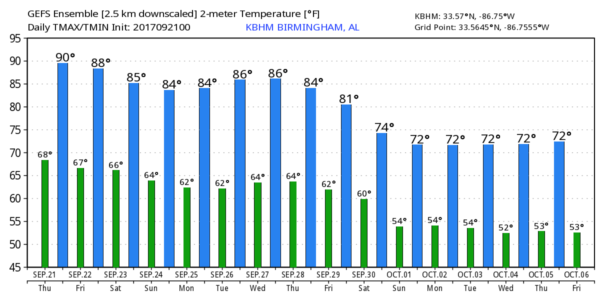
Afternoon highs will remain in the mid to upper 80s, about 5 degrees above average for mid to late September. The average high for Birmingham for Sept. 21 is 84.
FALL ARRIVES TOMORROW: While we have been in meteorological fall since Sept. 1, astronomical fall begins tomorrow at 3:02 p.m., the time of the autumnal equinox. This is when we have approximately 12 hours of daylight and 12 hours of darkness as the sun is directly over the equator. Just understand it doesn’t magically turn cool around here on the day of the equinox.
FOOTBALL WEATHER: For Friday night’s high school games, it will be warm and humid, with temperatures falling from the low 80s at kickoff into the upper 70s by the final whistle. Just a slight risk of a shower during the first quarter.
Alabama will be in Nashville Saturday to take on the Vanderbilt Commodores (2:30 p.m. kickoff). The sky will be mostly sunny with a kickoff temperature near 88 degrees, falling into the mid 80s by the fourth quarter. Just a small risk of a brief shower.
Auburn is also on the road, playing Missouri in Columbia Saturday evening (6:30 p.m. kickoff). We expect a clear sky with temperatures falling from 84 degrees at kickoff into the upper 70s by the final whistle.
And UAB is also traveling this weekend, playing North Texas Saturday evening (5:30 p.m. kickoff) in Denton. The weather will be dry with a fair sky; about 90 degrees at kickoff, falling through the 80s during the game.
PATTERN CHANGE: Global models show a major pattern change in 8-10 days, with a deep upper trough developing over the eastern U.S. This should open the door for much cooler air as October begins. But the pattern looks pretty dry for a while, and don’t forget October is usually our driest month of the year.
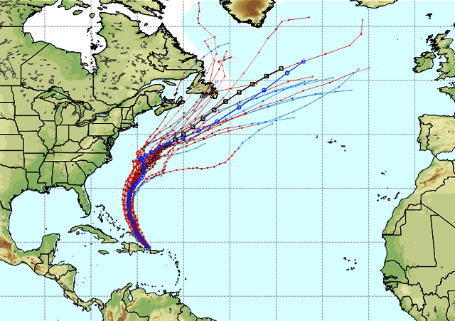
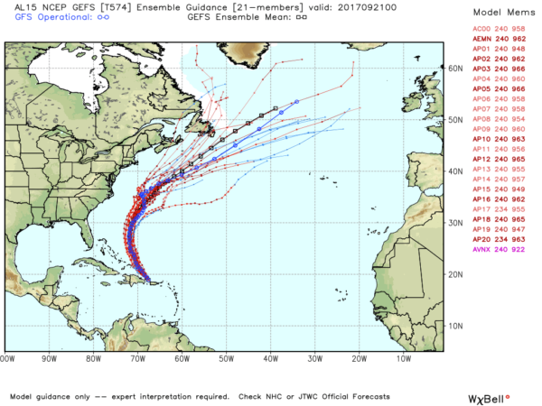
EYES ON MARIA: Now a category 3 hurricane with sustained winds of 115 mph just north of the Dominican Republic, Maria will gain latitude in coming days and will move northward, east of the Bahamas, this weekend.

Confidence is growing that Maria will not directly impact the U.S. East Coast, thanks to a weakness in the subtropical ridge north of the system left by Tropical Storm Jose, which is still spinning away east of New England.
BEACH FORECAST: Click here to see the AlabamaWx Beach Forecast Center page.
WEATHER BRAINS: You can listen to our weekly 90-minute netcast anytime on the web, or on iTunes. This is the show all about weather featuring many familiar voices, including meteorologists at ABC 33/40.
CONNECT: You can find me on all of the major social networks:
Facebook
Twitter
Google Plus
Instagram
Pinterest
Snapchat: spannwx
For more weather news and information from James Spann and his weather team, visit Alabama Wx.


