James Spann: Alabama in a cold pattern; a few snowflakes possible Friday morning
James Spann: Alabama stays cold the rest of this week from Alabama NewsCenter on Vimeo.
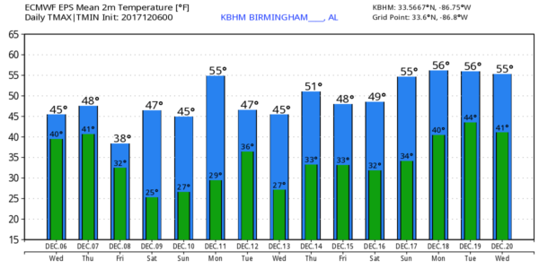
COLD AIR SETTLES INTO ALABAMA: Temperatures are generally between 36 and 42 degrees this morning, and unfortunately they won’t change much through the day as cold air advection continues in the low levels. The day will be cloudy, highs will be in the 40s and we could see some patchy light rain or drizzle. Not exactly a “Chamber of Commerce” kind of day. Most of the measurable rain today should be over the southern half of the state as moist air rides up and over the cold air near the surface.
Not much change tomorrow; a cloudy and cold day with rain at times, especially over central and south Alabama. The high should be in the 45- to 49-degree range.
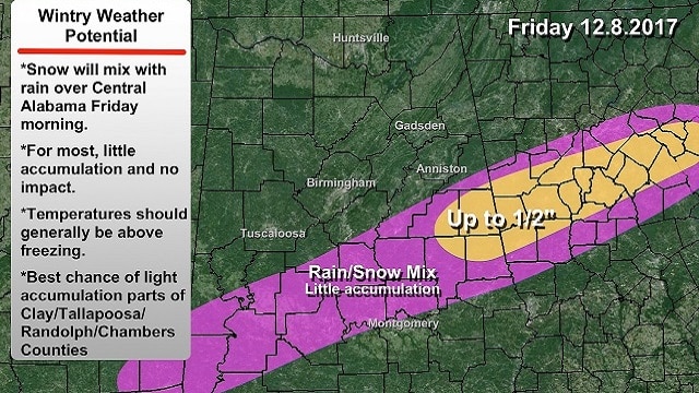
FRIDAY MORNING SNOW FLAKES? There is decent model agreement in the Friday morning situation. The overrunning pattern continues and the precipitation shield will creep up into central Alabama, where thermal profiles suggest snow will mix in with the rain. The best chance of seeing snowflakes will be south of a line from Demopolis to Jemison to Ranburne. For most, there will be no accumulation with a relatively warm ground and surface temperatures above freezing. However, there could be some accumulation on grassy areas, perhaps up to one-half inch, over parts of Clay, Randolph, Chambers and Tallapoosa counties, where the air will be colder.
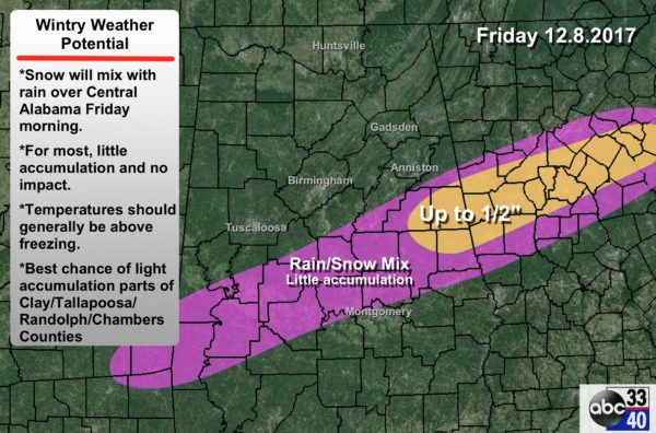
Some important points:
- Any snow Friday morning should be south of Tuscaloosa and Birmingham, and probably south of Anniston.
- Roads should be mostly wet with surface temperatures above freezing, meaning little if any impact.
- If moisture lingers on roads Friday night, there could be a few icy spots over east Alabama as temperatures fall below freezing.
- We will have to watch for any potential evaporative cooling effect Friday morning, which would lower temperatures near the surface to levels before forecast. Not likely, but always something to keep an eye on.
- Be sure and stay up with current updates for possible forecast changes if you are in east-central Alabama.
For the northern half of Alabama, Friday will be mostly cloudy and cold, with a high in the 40s.
THE ALABAMA WEEKEND: For most, it will be cold and dry with mostly sunny days and fair nights; highs will be in the 40s and lows in the 20s. A few snow flurries are possible near the Tennessee border Saturday morning, thanks to a clipper system passing north of the state.
FOOTBALL WEATHER: For the Alabama “Super 7” AHSAA state football championship games in Tuscaloosa today through Friday, the weather will be mostly cloudy and cold. Temperatures will be in the 40s for the day games and in the upper 30s for the night sessions. Maybe a touch of light rain or drizzle at times, but generally it will be dry.
NEXT WEEK AND BEYOND: The upper trough should remain anchored over the eastern third of the nation, and the overall pattern looks dry with below-average temperatures for next week.
BEACH FORECAST: Click here to see the AlabamaWx Beach Forecast Center page.
WEATHER BRAINS: You can listen to our weekly 90-minute netcast anytime on the web, or on iTunes. This is the show all about weather featuring many familiar voices, including meteorologists at ABC 33/40.
CONNECT: You can find me on all of the major social networks:
Facebook
Twitter
Google Plus
Instagram
Pinterest
Snapchat: spannwx
For more weather news and information from James Spann and his team, visit AlabamaWx.


