James Spann: Rain returns to Alabama Saturday; much colder Sunday
RADAR CHECK: After the soaking rain this morning, the sun managed to peek through the clouds across parts of Alabama during the midday, pushing temperatures into the low 70s and making the air rather unstable. A number of scattered showers are on radar at mid-afternoon, moving east. There is little thunder, and no additional risk of severe storms.
Showers will end this evening, and the sky will be mostly cloudy overnight with a low between 48 and 52.
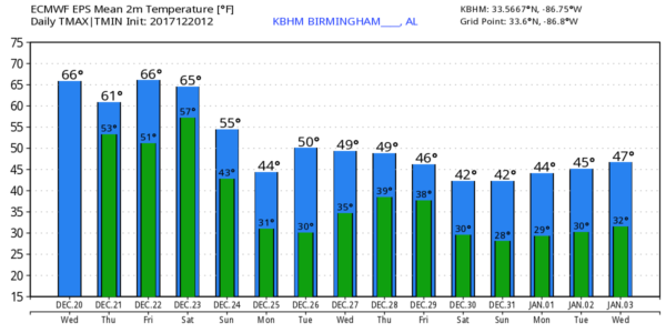
TOMORROW/FRIDAY: Tomorrow will be dry and mild; with a mix of sun and clouds, we expect a high between 66 and 69 degrees. Most of the day Friday will stay dry, although clouds will increase during the day. Friday’s high should be in the upper 60s.
Rain will push back into Alabama at some point Friday night ahead of an Arctic cold front. Some thunder is possible, but severe storms are not expected.
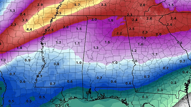
THE ALABAMA WEEKEND: Saturday will be wet as the front slowly approaches. Models are a tad slower, so it looks like temperatures should be in the 60s much of the day, with the cold air holding off until Saturday night. It won’t rain all day Saturday, but a decent part of the day will be wet. Some thunder is possible, but no severe weather is expected. Rain amounts Friday night and Saturday should be in the 1- to 2-inch range.
The sky becomes partly to mostly sunny Sunday, and noticeably colder. The high will be in the upper 40s with a brisk north wind.
FOOTBALL WEATHER: The annual Birmingham Bowl is Saturday, featuring Texas Tech vs. South Florida. The game kicks off at 11 a.m. at Legion Field. The sky will be cloudy, with rain likely during the game; temperatures will be in the 50s. Not exactly “Chamber of Commerce” weather, but on the positive side there is no severe weather risk, and I doubt if any thunderstorms will be involved.
CHRISTMAS DAY: The weather will be sunny and cold; we start the day in the 20s, and the high Monday afternoon will be in the mid 40s.
REST OF NEXT WEEK: Tuesday and Wednesday will be cold and dry; beyond that there are some big timing differences with the next system. The Global Forecast System brings in the rain Thursday, while the Euro holds it off until Friday. Both models suggest there could be a period of wintry precipitation on the back side before it ends, but at this time there is no way to resolve a specific forecast. Much colder air invades the state for the New Year’s Eve weekend.
RANDOLPH COUNTY DAMAGE: A possible small tornado touched down this morning near Roanoke; a barn and other buildings were damaged. National Weather Service meteorologists will survey the damage to determine whether this was from a tornado or straight-line winds.
BEACH FORECAST: Click here to see the AlabamaWx Beach Forecast Center page.
WEATHER BRAINS: You can listen to our weekly 90-minute netcast anytime on the web, or on iTunes. This is the show all about weather featuring many familiar voices, including meteorologists at ABC 33/40.
CONNECT: You can find me on all of the major social networks:
Facebook
Twitter
Google Plus
Instagram
Pinterest
Snapchat: spannwx
For more weather news and information from James Spann and his team, visit AlabamaWx.


