Brian Peters: Rain takes Alabama on a roller coaster ride
Brian Peters: Three rain events for Alabama in the next week, starting late today from Alabama NewsCenter on Vimeo.
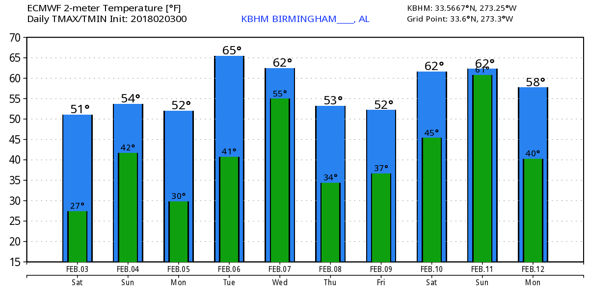
Strap in! It looks like we’re in for a real ride on a roller coaster of rain for the week ahead. The weekend starts out dry for much of the day, but we’ll see a good deal of clouds as the rain gets set to push into Alabama this evening. Looks like we’ll be about 10 degrees warmer today than yesterday as the surface high pushes toward coastal North Carolina, bringing good southerly flow back into the Southeast.
Rain will taper off tomorrow morning with a dry afternoon and evening for Sunday. Temperatures don’t change much, with highs in the middle 50s. There could be some thunder associated with the morning rain on Sunday, but the lapse rates aloft are not especially strong, so there does not appear to be a risk for severe storms.
On Monday we should remain dry as the upper flow goes nearly zonal and a surface high-pressure system migrates across the Ohio River Valley. Temperatures Monday will dip back a little, with highs around the 50-degree mark.
On Tuesday we moisten up once again by afternoon as another trough comes rapidly eastward out of the Four Corners area. Again there is a potential that we’ll hear some thunder, but again the lapse rates aloft do not appear to be enough to forecast severe storms. With a surface low forecast to move across north Alabama Tuesday night into Wednesday morning and CAPE values in the 400 to 500 j/kg range, we’ll need to keep a close eye on the conditions for any change to the severe storm potential. Tuesday will be warm, with a strong southerly flow and highs in the lower 60s.
The rain moves out for the afternoon on Wednesday as we once again dry out and cool down. Wednesday could be another one of those days where the temperature goes the wrong direction as it falls during the day. Fortunately, it is cooler air – not cold air – so temperatures are likely to fall through the 50s.
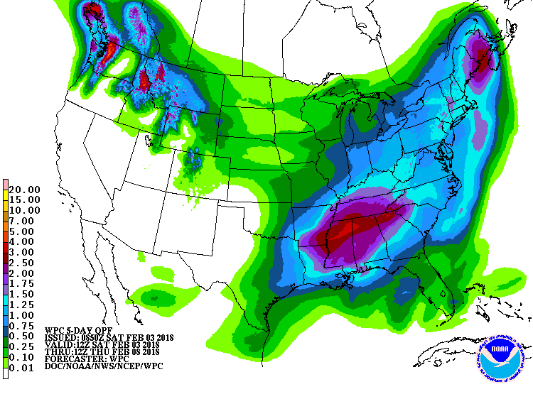
Thursday and Friday look dry for the Southeast with highs in the lower 60s, a bit warmer than our seasonal 30-year averages. A combination of strong southwesterly flow aloft along with several weak disturbances in that flow means we moisten up again, with rain potentially moving into Alabama from the west during Friday afternoon and continuing into much of Saturday. Highs will be in the 60s.
Rainfall amounts through Thursday morning will be in the 1- to 2-inch range with the rainfall events this evening and again Tuesday/Wednesday. The parade of these wet events is a good thing, since we have moved into drought conditions.
Looking into voodoo country, the pattern remains active with another strong-looking trough for Feb. 11. That one moves by on Feb. 12 with a broad ridge setting up by Valentine’s Day. By the 16th we have a series of strong short waves moving across the country, and the second one promises to dig a fairly deep trough into the East Coast, again reminding us that winter is not yet over.
BEACH FORECAST: Click here to see the AlabamaWx Beach Forecast Center page.
WEATHERBRAINS: You can listen to our weekly 90-minute netcast anytime on the web, or on iTunes. This is the show all about weather featuring many familiar voices, including meteorologists at ABC 33/40.
Enjoy your day and Godspeed.
For more weather news and information from James Spann, Brian Peters and other members of the James Spann team, visit AlabamaWx.


