James Spann: Alabama gets a few weekend showers

We have a mix of sun and mid- to high-level clouds over the northern half of Alabama today, with a sunny sky for the southern counties. Temperatures are mostly in the 60s.
Clouds will increase tonight and tomorrow ahead of a compact system that will pass just north of Alabama, and we will have the risk of a few showers over the weekend. A decent part of the day tomorrow will be dry, with just widely scattered showers; rain will be a little more likely tomorrow night and Sunday as a surface front stalls over central Alabama. The weekend will be mild, with highs in the 70s.
NEXT WEEK: A wedge front will creep in from the east; Monday looks very cool and wet, with periods of rain. Temperatures won’t get out of the 50s, and some east Alabama communities could be locked into the upper 40s. On Tuesday, the wedge breaks down and we rise to near 70 with a few scattered showers. Then, showers and storms will increase Wednesday and Thursday. We will monitor that system for severe weather potential; the latest global model runs suggest heavy rain could be the biggest threat.
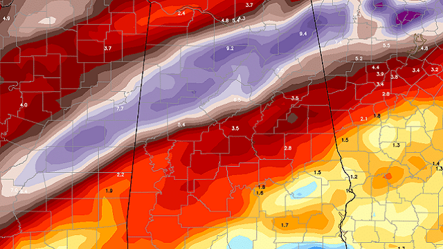
The Global Forecast System paints a strip of very heavy rain (5 to 10 inches) over north Alabama over the next seven days.

For now we see no sign of any freezing temperatures through early April, but I expect one more chance of a freeze/frost.

BEACH FORECAST: Click here to see the AlabamaWx Beach Forecast Center page.
WEATHER BRAINS: You can listen to our weekly 90-minute netcast any time on the web or on iTunes. This is the show all about weather featuring many familiar voices, including meteorologists at ABC 33/40.
CONNECT: You can find me on all of the major social networks:
Facebook
Twitter
Google Plus
Instagram
Pinterest
Snapchat: spannwx
For more weather news and information from James Spann and his team, visit AlabamaWx.


